
MED SEA
General Cargo
Current Trip
| Time Travelled | 4 days |
|---|---|
| Remaining Time | --- |
| Distance Travelled | 155.31 nm |
| Remaining Distance | --- |
| AVG Speed | 9.8 Knop |
| MAX Speed | 11.4 Knop |
| AVG Wind | 18.6 knots |
| MAX Wind | 25 knots |
| MIN Temp | 3.4°C / 38.12°F |
| MAX Temp | 11.7°C / 53.06°F |
| Djupgående | 0 m |
| Position mottagen | 4 d sen |
Current Position
| Longitud | 35.71335° |
|---|---|
| Latitude | 34.50893° |
| Status | Under way using engine |
| Fart | 7.1 Knop |
| Kurs | 89.4° |
| Område | Mediterranean Sea - Eastern Basin |
| Station | T-AIS |
| Position mottagen | 4 d sen |
Info
Information
The current position of MED SEA is in Mediterranean Sea - Eastern Basin with coordinates 34.50893° / 35.71335° as reported on 2025-02-07 10:34 by AIS to our vessel tracker app. The vessel's current speed is 7.1 Knop
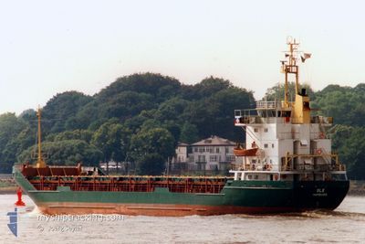
The vessel MED SEA (IMO: 7633387, MMSI: 511100605) is a General Cargo that was built in 1977 ( 48 År gammal ). It's sailing under the flag of [PW] Palau.
In this page you can find informations about the vessels current position, last detected port calls, and current voyage information. If the vessels is not in coverage by AIS you will find the latest position.
The current position of MED SEA is detected by our AIS receivers and we are not responsible for the reliability of the data. The last position was recorded while the vessel was in Coverage by the Ais receivers of our vessel tracking app.
Weather
| Temperature | 11.4°C / 52.52°F |
|---|---|
| Wind Speed | 14 knots |
| Direction | 257° WSW |
| Pressure | 1018.1 hPa |
| Humidity | 58 % |
| Cloud Coverage | 100 % |
Featured Company
Last Port Calls
| Port | Arrival | Departure | Time In Port |
|---|---|---|---|
| 2025-02-03 01:18 | 2025-02-06 18:53 | 3 d | |
| 2025-01-29 07:49 | 2025-02-03 00:33 | 4 d | |
| 2025-01-18 05:51 | 2025-01-24 12:05 | 6 d | |
| 2025-01-02 05:04 | 2025-01-09 16:14 | 7 d | |
| 2024-12-27 08:00 | 2024-12-30 19:33 | 3 d | |
| 2024-12-10 15:20 | 2024-12-14 21:49 | 4 d |
Last Trips
| Origin | Departure | Destination | Arrival | Distance | |
|---|---|---|---|---|---|
| 2025-02-03 03:33 | 2025-02-03 04:18 | 3.63 nm | |||
| 2025-01-24 14:05 | 2025-01-29 10:49 | 251.08 nm | |||
| 2025-01-09 18:14 | 2025-01-18 07:51 | 36.45 nm | |||
| 2024-12-30 22:33 | 2025-01-02 07:04 | 328.40 nm | |||
| 2024-12-14 23:49 | 2024-12-27 11:00 | 713.02 nm | |||
| 2024-11-30 16:24 | 2024-12-10 17:20 | 343.51 nm |
Events
| Tid | Event | Detaljer | Position / Dest | Information |
|---|---|---|---|---|
| 2025-02-07 10:34 | UTANFÖR täckningsområde |
34.50893 / 35.71335
Mediterranean Sea - Eastern Basin
|
Fart: 7.1 kn Kurs: 89.4° |
|
| 2025-02-07 08:58 | Upptäckt i hav | Lebanese part of the Mediterranean Sea - Eastern Basin |
34.58171 / 35.50099
Mediterranean Sea - Eastern Basin
|
Fart: 10 kn Kurs: 178.8° |
| 2025-02-07 08:58 | I täckningsområde |
34.58171 / 35.50099
Mediterranean Sea - Eastern Basin
|
Fart: 10 kn Kurs: 178.8° |
|
| 2025-02-07 02:40 | Status ändrad | Default Under way using engine |
35.69434 / 35.49709
TRIPOLI
|
Fart: 10 kn Kurs: 180.5° |
| 2025-02-07 02:26 | UTANFÖR täckningsområde |
35.73425 / 35.49656
Mediterranean Sea - Eastern Basin
|
Fart: 10 kn Kurs: 180.5° |
|
| 2025-02-07 02:09 | Status ändrad | Under way using engine Default |
35.78254 / 35.49943
TRIPOLI
|
Fart: 9.8 kn Kurs: 187° |
| 2025-02-07 01:34 | Status ändrad | Default Under way using engine |
35.87496 / 35.51026
TRIPOLI
|
Fart: 9.7 kn Kurs: 184.7° |
| 2025-02-07 01:30 | Status ändrad | Under way using engine Default |
35.88620 / 35.51141
TRIPOLI
|
Fart: 9.6 kn Kurs: 185° |
| 2025-02-07 00:55 | Status ändrad | Default Under way using engine |
35.98153 / 35.51956
TRIPOLI
|
Fart: 9.9 kn Kurs: 184.1° |
| 2025-02-07 00:28 | Byter havsområde | Syrian part of the Mediterranean Sea - Eastern Basin Turkish part of the Mediterranean Sea - Eastern Basin |
36.05848 / 35.52604
Mediterranean Sea - Eastern Basin
|
Fart: 10.6 kn Kurs: 183.8° |