
MED SEA
General Cargo
Current Trip
| Trip Time | 45 mins |
|---|---|
| Trip Distance | 3.63 nm |
| AVG Speed | 6.8 Knopen |
| MAX Speed | 9.7 Knopen |
| Diepgang | 0 M |
| AVG Wind | 1.6 knots |
| MAX Wind | 2.2 knots |
| MIN Temp | 7.9°C / 46.22°F |
| MAX Temp | 9.6°C / 49.28°F |
| Positie ontvangen | 11 d geleden |
Current Position
| Lengtegraad | 35.85302° |
|---|---|
| Breedtegraat | 36.49967° |
| Status | Under way using engine |
| Snelheid | 8.2 Knopen |
| Koers | 48.5° |
| Gebied | Mediterranean Sea - Eastern Basin |
| Station | T-AIS |
| Positie ontvangen | 11 d geleden |
Info
Information
The current position of MED SEA is in Mediterranean Sea - Eastern Basin with coordinates 36.49967° / 35.85302° as reported on 2025-01-26 07:59 by AIS to our vessel tracker app. The vessel's current speed is 8.2 Knopen and is currently inside the port of ISKENDERUN.
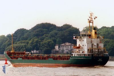
The vessel MED SEA (IMO: 7633387, MMSI: 511100605) is a General Cargo that was built in 1977 ( 48 Jaar oud ). It's sailing under the flag of [PW] Palau.
In this page you can find informations about the vessels current position, last detected port calls, and current voyage information. If the vessels is not in coverage by AIS you will find the latest position.
The current position of MED SEA is detected by our AIS receivers and we are not responsible for the reliability of the data. The last position was recorded while the vessel was in Coverage by the Ais receivers of our vessel tracking app.
Weather
| Temperature | 6.1°C / 42.98°F |
|---|---|
| Wind Speed | 8 knots |
| Direction | 308° NW |
| Pressure | 1007.1 hPa |
| Humidity | 54.4 % |
| Cloud Coverage | 100 % |
Featured Company
Last Port Calls
| Port | Arrival | Departure | Time In Port |
|---|---|---|---|
| 2025-02-03 04:18 | |||
| 2025-01-29 10:49 | 2025-02-03 03:33 | 4 d | |
| 2025-01-18 07:51 | 2025-01-24 14:05 | 6 d | |
| 2025-01-02 07:04 | 2025-01-09 18:14 | 7 d | |
| 2024-12-27 11:00 | 2024-12-30 22:33 | 3 d | |
| 2024-12-10 17:20 | 2024-12-14 23:49 | 4 d |
Last Trips
| Origin | Departure | Destination | Arrival | Distance | |
|---|---|---|---|---|---|
| 2025-02-03 03:33 | 2025-02-03 04:18 | 3.63 nm | |||
| 2025-01-24 14:05 | 2025-01-29 10:49 | 251.08 nm | |||
| 2025-01-09 18:14 | 2025-01-18 07:51 | 36.45 nm | |||
| 2024-12-30 22:33 | 2025-01-02 07:04 | 328.40 nm | |||
| 2024-12-14 23:49 | 2024-12-27 11:00 | 713.02 nm | |||
| 2024-11-30 16:24 | 2024-12-10 17:20 | 343.51 nm |
Events
| Tijd | Evenement | Details | Positie / Bestemming | Info |
|---|---|---|---|---|
| 2025-02-03 01:18 | Stop beweging |
36.60279 / 36.15664
[TR] ISKENDERUN
|
Snelheid: 0.2 kn Koers: 223° |
|
| 2025-02-03 01:18 | Aankomsthaven |
|
36.60279 / 36.15664
[TR] ISKENDERUN
|
Snelheid: 1.5 kn Koers: 207° |
| 2025-02-03 00:33 | Vertrekhaven |
|
36.67272 / 36.17185
ISKENDRUN
|
Snelheid: 5.6 kn Koers: 200° |
| 2025-02-03 00:13 | Start beweging |
36.69698 / 36.18859
[TR] ISKENDERUN
|
Snelheid: 5.3 kn Koers: 253° |
|
| 2025-01-29 08:09 | Stop beweging |
36.69718 / 36.19346
[TR] ISKENDERUN
|
Snelheid: 0.2 kn Koers: 247° |
|
| 2025-01-29 07:49 | Aankomsthaven |
|
36.69500 / 36.18068
[TR] ISKENDERUN
|
Snelheid: 6.6 kn Koers: 33° |
| 2025-01-29 07:05 | Start beweging | 1.89 nm, West of ISKENDERUN |
36.60495 / 36.13678
ISKENDRUN
|
Snelheid: 5.3 kn Koers: 356° |
| 2025-01-28 15:55 | Stop beweging | 1.72 nm, West of ISKENDERUN |
36.60050 / 36.14196
ISKENDRUN
|
Snelheid: Koers: 222° |
| 2025-01-28 15:48 | Start beweging | 1.88 nm, West of ISKENDERUN |
36.60148 / 36.13807
ISKENDRUN
|
Snelheid: 55.7 kn Koers: 295° |