

RIVIERA
Cargo

Current Trip
| Time Travelled | 19 days |
|---|---|
| Remaining Time | --- |
| Distance Travelled | 602.26 nm |
| Remaining Distance | --- |
| AVG Speed | 7.5 Knop |
| MAX Speed | 17.8 Knop |
| AVG Wind | 4.9 knots |
| MAX Wind | 9 knots |
| MIN Temp | 5.3°C / 41.54°F |
| MAX Temp | 24.3°C / 75.74°F |
| Djupgående | 1.8 m |
| Position mottagen | 2 d sen |
Current Position
| Longitud | 11.05296° |
|---|---|
| Latitude | 49.69922° |
| Status | Under way using engine |
| Fart | 6 Knop |
| Kurs | 12.3° |
| Område | North Sea |
| Station | T-AIS |
| Position mottagen | 2 d sen |
Information
The current position of RIVIERA is in North Sea with coordinates 49.69922° / 11.05296° as reported on 2025-05-18 04:12 by AIS to our vessel tracker app. The vessel's current speed is 6 Knop and is heading at the port of KAMPEN.
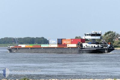
The vessel RIVIERA (MMSI: 244700375) is a Cargo It's sailing under the flag of [NL] Netherlands.
In this page you can find informations about the vessels current position, last detected port calls, and current voyage information. If the vessels is not in coverage by AIS you will find the latest position.
The current position of RIVIERA is detected by our AIS receivers and we are not responsible for the reliability of the data. The last position was recorded while the vessel was in Coverage by the Ais receivers of our vessel tracking app.
The current draught of RIVIERA as reported by AIS is 1.8 meters
Weather
| Temperature | 5.5°C / 41.9°F |
|---|---|
| Wind Speed | 2 knots |
| Direction | 277° W |
| Pressure | 1015.4 hPa |
| Humidity | 94.5 % |
| Cloud Coverage | 69 % |


Featured Company
Last Port Calls
| Port | Arrival | Departure | Time In Port |
|---|---|---|---|
| 2025-05-01 06:26 | |||
| 2025-04-18 19:22 | 2025-04-18 19:45 | 22 m | |
| 2025-04-18 17:30 | 2025-04-18 18:14 | 44 m | |
| 2025-04-18 15:57 | 2025-04-18 16:46 | 49 m | |
| 2025-04-18 12:51 | 2025-04-18 13:26 | 35 m | |
| 2025-04-16 20:54 | 2025-04-17 06:51 | 9 h | |
| 2025-04-15 19:24 | 2025-04-15 20:31 | 1 h | |
| 2025-04-15 13:20 | 2025-04-15 14:06 | 46 m | |
| 2025-04-15 08:16 | 2025-04-15 09:15 | 59 m | |
| 2025-04-14 12:43 | 2025-04-15 07:05 | 18 h |
Last Trips
| Origin | Departure | Destination | Arrival | Distance | |
|---|---|---|---|---|---|
| 2025-04-18 18:14 | 2025-04-18 19:22 | 6.66 nm | |||
| 2025-04-18 16:46 | 2025-04-18 17:30 | 4.22 nm | |||
| 2025-04-18 13:26 | 2025-04-18 15:57 | 11.90 nm | |||
| 2025-04-17 06:51 | 2025-04-18 12:51 | 90.72 nm | |||
| 2025-04-15 20:31 | 2025-04-16 20:54 | 87.89 nm | |||
| 2025-04-15 14:06 | 2025-04-15 19:24 | 33.78 nm | |||
| 2025-04-15 09:15 | 2025-04-15 13:20 | 30.76 nm | |||
| 2025-04-15 07:05 | 2025-04-15 08:16 | 9.49 nm | |||
| 2025-04-14 10:36 | 2025-04-14 12:43 | 11.54 nm | |||
| 2025-04-12 09:45 | 2025-04-13 16:30 | 29.01 nm |
Events
| Tid | Event | Detaljer | Position / Dest | Information |
|---|---|---|---|---|
| 2025-05-18 04:12 | UTANFÖR täckningsområde |
49.69922 / 11.05296
North Sea
|
Fart: 6 kn Kurs: 12.3° |
|
| 2025-05-18 04:04 | I täckningsområde |
49.68814 / 11.04192
North Sea
|
Fart: 3.3 kn Kurs: 38.1° |
|
| 2025-05-18 02:58 | UTANFÖR täckningsområde |
49.68758 / 11.04126
North Sea
|
Fart: Kurs: 49.2° |
|
| 2025-05-18 01:58 | I täckningsområde |
49.68758 / 11.04125
North Sea
|
Fart: Kurs: 49.2° |
|
| 2025-05-17 23:01 | UTANFÖR täckningsområde |
49.68759 / 11.04124
North Sea
|
Fart: Kurs: 49.2° |
|
| 2025-05-17 22:40 | I täckningsområde |
49.68758 / 11.04126
North Sea
|
Fart: Kurs: 49.2° |
|
| 2025-05-17 21:37 | UTANFÖR täckningsområde |
49.68760 / 11.04126
North Sea
|
Fart: 0.1 kn Kurs: 98° |
|
| 2025-05-17 20:58 | Status ändrad | Moored Under way using engine |
49.68760 / 11.04126
KAMPEN
|
Fart: Kurs: 42° |
| 2025-05-17 19:43 | STOPPAR förflyttning | 13.9 nm, South East of BAMBERG |
49.68487 / 11.03722
KAMPEN
|
Fart: 0.2 kn Kurs: 42° |
| 2025-05-17 19:13 | I täckningsområde |
49.64633 / 11.00448
North Sea
|
Fart: 6 kn Kurs: 42.4° |