
ALBLAS
Passenger
Current Trip
| Time Travelled | 3 h, 28 mins |
|---|---|
| Remaining Time | -13 mins |
| Distance Travelled | 49.04 nm |
| Remaining Distance | 0.36 nm |
| AVG Speed | 17.1 Knots |
| MAX Speed | 23.4 Knots |
| AVG Wind | 8.1 knots |
| MAX Wind | 9.7 knots |
| MIN Temp | 3.6°C / 38.48°F |
| MAX Temp | 8.2°C / 46.76°F |
| Draught | 0.2 m |
| Position Received | 2 m ago |
Current Position
| Longitude | 4.61061° |
|---|---|
| Latitude | 51.89133° |
| Status | Under way using engine |
| Speed | 20.7 Knots |
| Course | 286.1° |
| Area | Gulf of Guinea |
| Station | T-AIS |
| Position Received | 2 m ago |
Info
Information
The current position of ALBLAS is in Gulf of Guinea with coordinates 51.89133° / 4.61061° as reported on 2025-12-14 11:50 by AIS to our vessel tracker app. The vessel's current speed is 20.7 Knots and is heading at the port of RIDDERKERK. The estimated time of arrival as calculated by MyShipTracking vessel tracking app is 2025-12-14 11:39 LT
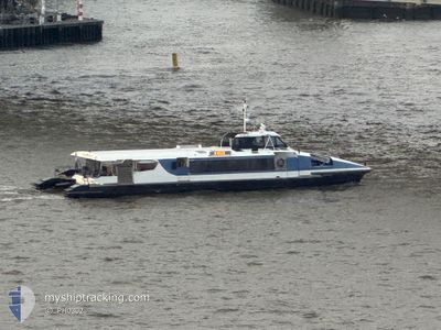
The vessel ALBLAS (MMSI: 244750276) is a Passenger It's sailing under the flag of [NL] Netherlands.
In this page you can find informations about the vessels current position, last detected port calls, and current voyage information. If the vessels is not in coverage by AIS you will find the latest position.
The current position of ALBLAS is detected by our AIS receivers and we are not responsible for the reliability of the data. The last position was recorded while the vessel was in Coverage by the Ais receivers of our vessel tracking app.
The current draught of ALBLAS as reported by AIS is 0.2 meters
Weather
| Temperature | 7.7°C / 45.86°F |
|---|---|
| Wind Speed | 9 knots |
| Direction | 201° SSW |
| Pressure | 1022.9 hPa |
| Humidity | 86.5 % |
| Cloud Coverage | 30 % |
Featured Company
Last Port Calls
| Port | Arrival | Departure | Time In Port |
|---|---|---|---|
| 2025-12-12 17:22 | 2025-12-14 08:24 | 1 d | |
| 2025-12-11 19:06 | 2025-12-12 06:52 | 11 h | |
| 2025-12-11 18:25 | 2025-12-11 18:38 | 12 m | |
| 2025-12-11 18:18 | 2025-12-11 18:23 | 5 m | |
| 2025-12-11 17:33 | 2025-12-11 17:36 | 2 m | |
| 2025-12-11 17:25 | 2025-12-11 17:29 | 3 m | |
| 2025-12-11 17:18 | 2025-12-11 17:20 | 2 m | |
| 2025-12-11 17:12 | 2025-12-11 17:14 | 2 m | |
| 2025-12-11 17:05 | 2025-12-11 17:07 | 2 m | |
| 2025-12-11 16:51 | 2025-12-11 16:55 | 4 m |
Most Visited Ports (Last year)
| Port | Arrivals | |
|---|---|---|
| 2201 | ||
| 1874 | ||
| 793 | ||
| 745 | ||
| 741 | ||
| 721 |
Last Trips
| Origin | Departure | Destination | Arrival | Distance | |
|---|---|---|---|---|---|
| 2025-12-12 07:52 | 2025-12-12 18:22 | 136.44 nm | |||
| 2025-12-11 19:38 | 2025-12-11 20:06 | 4.72 nm | |||
| 2025-12-11 19:23 | 2025-12-11 19:25 | 1.73 nm | |||
| 2025-12-11 18:36 | 2025-12-11 19:18 | 8.13 nm | |||
| 2025-12-11 18:29 | 2025-12-11 18:33 | 1.16 nm | |||
| 2025-12-11 18:20 | 2025-12-11 18:25 | 1.36 nm | |||
| 2025-12-11 18:14 | 2025-12-11 18:18 | 0.30 nm | |||
| 2025-12-11 18:07 | 2025-12-11 18:12 | 0.64 nm | |||
| 2025-12-11 17:55 | 2025-12-11 18:05 | 1.26 nm | |||
| 2025-12-11 17:46 | 2025-12-11 17:51 | 1.67 nm |
Events
| Time | Event | Details | Position / Dest | Info |
|---|---|---|---|---|
| 2025-12-14 11:47 | START Moving | 0.53 nm, North East of RIDDERKERK |
51.88978 / 4.62920
ROTTERDAM:ST. JOBSHA
|
Speed: 10 kn Course: 272.2° |
| 2025-12-14 11:41 | STOP Moving | 0.72 nm, North East of RIDDERKERK |
51.88979 / 4.63542
ROTTERDAM:ST. JOBSHA
|
Speed: 0.2 kn Course: 511° |
| 2025-12-14 11:16 | START Moving | 0.62 nm, North West of ROTTERDAM CENTRUM |
51.90957 / 4.48485
ROTTERDAM:ST. JOBSHA
|
Speed: 10.9 kn Course: 54.1° |
| 2025-12-14 11:13 | STOP Moving | 0.66 nm, North West of ROTTERDAM CENTRUM |
51.90865 / 4.48235
ROTTERDAM:ST. JOBSHA
|
Speed: 0.3 kn Course: 511° |
| 2025-12-14 10:47 | START Moving | 0.54 nm, North East of RIDDERKERK |
51.89001 / 4.62946
ROTTERDAM:ST. JOBSHA
|
Speed: 9.7 kn Course: 267.4° |
| 2025-12-14 10:42 | STOP Moving | 0.72 nm, North East of RIDDERKERK |
51.88978 / 4.63543
ROTTERDAM:ST. JOBSHA
|
Speed: 0.3 kn Course: 511° |
| 2025-12-14 10:18 | START Moving | 0.58 nm, North West of ROTTERDAM CENTRUM |
51.90920 / 4.48555
ROTTERDAM:ST. JOBSHA
|
Speed: 18.9 kn Course: 36.9° |
| 2025-12-14 10:15 | STOP Moving | 0.66 nm, North West of ROTTERDAM CENTRUM |
51.90857 / 4.48223
ROTTERDAM:ST. JOBSHA
|
Speed: 0.1 kn Course: 511° |
| 2025-12-14 09:48 | START Moving | 0.61 nm, North East of RIDDERKERK |
51.89040 / 4.63127
ROTTERDAM:ST. JOBSHA
|
Speed: 9 kn Course: 248.9° |
| 2025-12-14 09:42 | STOP Moving | 0.73 nm, North East of RIDDERKERK |
51.88979 / 4.63563
ROTTERDAM:ST. JOBSHA
|
Speed: Course: 511° |