
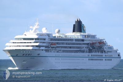
AMADEA
Passengers Ship
Current Trip
| Time Travelled | 5 days |
|---|---|
| Remaining Time | --- |
| Distance Travelled | 1879.03 nm |
| Remaining Distance | --- |
| AVG Speed | 15.1 Knots |
| MAX Speed | 17.2 Knots |
| AVG Wind | 8 knots |
| MAX Wind | 17 knots |
| MIN Temp | 17.2°C / 62.96°F |
| MAX Temp | 24.8°C / 76.64°F |
| Draught | 7.1 m |
| Position Received | 4 d ago |
Current Position
| Longitude | -16.83971° |
|---|---|
| Latitude | 27.48295° |
| Status | Under way using engine |
| Speed | 17.1 Knots |
| Course | 221.7° |
| Area | North Atlantic Ocean |
| Station | T-AIS |
| Position Received | 4 d ago |
Info
Information
The current position of AMADEA is in North Atlantic Ocean with coordinates 27.48295° / -16.83971° as reported on 2025-12-30 23:09 by AIS to our vessel tracker app. The vessel's current speed is 17.1 Knots and is heading at the port of ROSEAU. The estimated time of arrival as calculated by MyShipTracking vessel tracking app is 2026-01-07 08:00 LT
The vessel AMADEA (IMO: 8913162, MMSI: 308445000) is a Passengers Ship that was built in 1991 ( 35 years old ). It's sailing under the flag of [BS] Bahamas.
In this page you can find informations about the vessels current position, last detected port calls, and current voyage information. If the vessels is not in coverage by AIS you will find the latest position.
The current position of AMADEA is detected by our AIS receivers and we are not responsible for the reliability of the data. The last position was recorded while the vessel was in Coverage by the Ais receivers of our vessel tracking app.
The current draught of AMADEA as reported by AIS is 7.1 meters
Weather
| Temperature | 24.8°C / 76.64°F |
|---|---|
| Wind Speed | 8 knots |
| Direction | 117° ESE |
| Pressure | 1016.2 hPa |
| Humidity | 65.8 % |
| Cloud Coverage | 1 % |
Featured Company
Last Port Calls
| Port | Arrival | Departure | Time In Port |
|---|---|---|---|
| 2025-12-30 07:18 | 2025-12-30 18:09 | 10 h | |
| 2025-12-29 12:18 | 2025-12-29 19:01 | 6 h | |
| 2025-12-27 08:08 | 2025-12-27 20:51 | 12 h | |
| 2025-12-23 06:59 | 2025-12-23 20:26 | 13 h | |
| 2025-12-21 07:23 | 2025-12-21 19:36 | 12 h | |
| 2025-12-19 14:44 | 2025-12-20 18:38 | 1 d | |
| 2025-12-18 11:29 | 2025-12-18 19:11 | 7 h | |
| 2025-12-17 08:34 | 2025-12-18 07:11 | 22 h | |
| 2025-12-16 08:11 | 2025-12-16 22:55 | 14 h | |
| 2025-12-15 08:14 | 2025-12-15 20:19 | 12 h |
Most Visited Ports (Last year)
| Port | Arrivals | |
|---|---|---|
| 13 | ||
| 4 | ||
| 4 | ||
| 3 | ||
| 3 | ||
| 3 |
Last Trips
| Origin | Departure | Destination | Arrival | Distance | |
|---|---|---|---|---|---|
| 2025-12-29 19:01 | 2025-12-30 07:18 | 153.13 nm | |||
| 2025-12-27 20:51 | 2025-12-29 12:18 | 589.29 nm | |||
| 2025-12-23 20:26 | 2025-12-27 08:08 | 1234.70 nm | |||
| 2025-12-21 19:36 | 2025-12-23 06:59 | 461.50 nm | |||
| 2025-12-20 18:38 | 2025-12-21 07:23 | 157.94 nm | |||
| 2025-12-18 19:11 | 2025-12-19 14:44 | 182.12 nm | |||
| 2025-12-18 07:11 | 2025-12-18 11:29 | 53.38 nm | |||
| 2025-12-16 22:55 | 2025-12-17 08:34 | 107.09 nm | |||
| 2025-12-15 20:19 | 2025-12-16 08:11 | 128.84 nm | |||
| 2025-12-14 19:27 | 2025-12-15 08:14 | 148.92 nm |
Events
| Time | Event | Details | Position / Dest | Info |
|---|---|---|---|---|
| 2025-12-30 23:13 | Status Changed | Default Under way using engine |
27.46800 / -16.85465
DM RSU
|
Speed: 17.1 kn Course: 221.7° |
| 2025-12-30 23:09 | Status Changed | Under way using engine Default |
27.48295 / -16.83971
DM RSU
|
Speed: 17.1 kn Course: 222° |
| 2025-12-30 23:09 | OUT of Coverage |
27.48295 / -16.83971
North Atlantic Ocean
DM RSU
|
Speed: 17.1 kn Course: 221.7° |
|
| 2025-12-30 22:54 | Status Changed | Default Under way using engine |
27.53884 / -16.78613
DM RSU
|
Speed: 16.7 kn Course: 219.6° |
| 2025-12-30 22:46 | Status Changed | Under way using engine Default |
27.56566 / -16.76118
DM RSU
|
Speed: 16.8 kn Course: 219° |
| 2025-12-30 22:43 | Status Changed | Default Under way using engine |
27.57893 / -16.74892
DM RSU
|
Speed: 16.6 kn Course: 220.2° |
| 2025-12-30 22:31 | Status Changed | Under way using engine Default |
27.61994 / -16.71108
DM RSU
|
Speed: 16.5 kn Course: 220° |
| 2025-12-30 22:30 | Status Changed | Default Under way using engine |
27.62240 / -16.70874
DM RSU
|
Speed: 16.5 kn Course: 221.8° |
| 2025-12-30 22:15 | Status Changed | Under way using engine Default |
27.67673 / -16.65515
DM RSU
|
Speed: 16.1 kn Course: 223° |
| 2025-12-30 21:51 | Status Changed | Default Under way using engine |
27.75822 / -16.57564
DM RSU
|
Speed: 16 kn Course: 221.5° |