
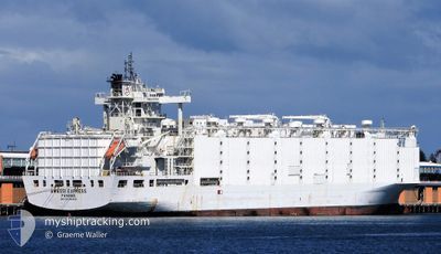
ANNA MARRA
Livestock Carrier
Current Trip
| Time Travelled | 7 days |
|---|---|
| Remaining Time | --- |
| Distance Travelled | 1387.27 nm |
| Remaining Distance | 11.81 nm |
| AVG Speed | 8.7 Knots |
| MAX Speed | 16.8 Knots |
| AVG Wind | 14.1 knots |
| MAX Wind | 28.5 knots |
| MIN Temp | 7.7°C / 45.86°F |
| MAX Temp | 16.2°C / 61.16°F |
| Draught | 9.1 m |
| Position Received | 17 m ago |
Current Position
| Longitude | 14.76503° |
|---|---|
| Latitude | 35.86913° |
| Status | At anchor |
| Speed | 0.1 Knots |
| Course | 76° |
| Area | Mediterranean Sea - Eastern Basin |
| Station | T-AIS |
| Position Received | 17 m ago |
Info
Information
The current position of ANNA MARRA is in Mediterranean Sea - Eastern Basin with coordinates 35.86913° / 14.76503° as reported on 2025-03-08 23:44 by AIS to our vessel tracker app. The vessel's current speed is 0.1 Knots and is heading at the port of VALLETTA. The estimated time of arrival as calculated by MyShipTracking vessel tracking app is 2025-03-04 21:00 LT
The vessel ANNA MARRA (IMO: 8901860, MMSI: 353816000) is a Livestock Carrier that was built in 1990 ( 35 years old ). It's sailing under the flag of [PA] Panama.
In this page you can find informations about the vessels current position, last detected port calls, and current voyage information. If the vessels is not in coverage by AIS you will find the latest position.
The current position of ANNA MARRA is detected by our AIS receivers and we are not responsible for the reliability of the data. The last position was recorded while the vessel was in Coverage by the Ais receivers of our vessel tracking app.
The current draught of ANNA MARRA as reported by AIS is 9.1 meters
Weather
| Temperature | 15.5°C / 59.9°F |
|---|---|
| Wind Speed | 11 knots |
| Direction | 4° N |
| Pressure | 1013.3 hPa |
| Humidity | 87.8 % |
| Cloud Coverage | 23 % |
Featured Company
Last Port Calls
| Port | Arrival | Departure | Time In Port |
|---|---|---|---|
| 2025-02-18 05:05 | 2025-03-01 19:45 | 11 d | |
| 2025-01-27 10:05 | 2025-02-01 13:12 | 5 d |
Most Visited Ports (Last year)
| Port | Arrivals | |
|---|---|---|
| 4 | ||
| 2 | ||
| 2 | ||
| 2 | ||
| 1 | ||
| 1 |
Last Trips
| Origin | Departure | Destination | Arrival | Distance | |
|---|---|---|---|---|---|
| 2025-02-01 10:12 | 2025-02-18 08:05 | 5409.72 nm | |||
| 2024-12-28 15:08 | 2025-01-27 07:05 | 5501.36 nm |
Events
| Time | Event | Details | Position / Dest | Info |
|---|---|---|---|---|
| 2025-03-08 23:47 | Status Changed | Default At anchor |
35.86927 / 14.76503
MT MLA
|
Speed: 0.1 kn Course: 76° |
| 2025-03-08 23:35 | Status Changed | At anchor Default |
35.86927 / 14.76512
MT MLA
|
Speed: Course: 90° |
| 2025-03-08 23:32 | Status Changed | Default At anchor |
35.86935 / 14.76508
MT MLA
|
Speed: 0.2 kn Course: 80° |
| 2025-03-08 23:08 | Status Changed | At anchor Default |
35.86908 / 14.76515
MT MLA
|
Speed: 0.1 kn Course: 89° |
| 2025-03-08 22:56 | Status Changed | Default At anchor |
35.86920 / 14.76508
MT MLA
|
Speed: 0.1 kn Course: 82° |
| 2025-03-08 22:41 | Status Changed | At anchor Default |
35.86897 / 14.76515
MT MLA
|
Speed: 0.1 kn Course: 91° |
| 2025-03-08 22:35 | Status Changed | Default At anchor |
35.86911 / 14.76508
MT MLA
|
Speed: 0.3 kn Course: 73° |
| 2025-03-08 22:26 | Status Changed | At anchor Default |
35.86902 / 14.76502
MT MLA
|
Speed: 0.2 kn Course: 73° |
| 2025-03-08 22:20 | Status Changed | Default At anchor |
35.86880 / 14.76513
MT MLA
|
Speed: 0.1 kn Course: 75° |
| 2025-03-08 22:14 | Status Changed | At anchor Default |
35.86882 / 14.76527
MT MLA
|
Speed: 0.2 kn Course: 80° |