
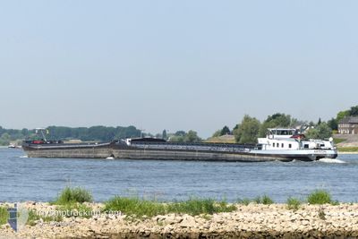
ARTEON
Cargo
Current Trip
BUNDESBAHNBRUCKE DAT
| Time Travelled | 34 mins |
|---|---|
| Remaining Time | --- |
| Distance Travelled | --- |
| Remaining Distance | --- |
| AVG Speed | --- |
| MAX Speed | --- |
| AVG Wind | --- |
| MAX Wind | --- |
| MIN Temp | --- |
| MAX Temp | --- |
| Draught | 2.7 m |
| Position Received | 1 d ago |
Current Position
| Longitude | 7.33479° |
|---|---|
| Latitude | 51.63070° |
| Status | Moored |
| Speed | |
| Course | --- |
| Area | North Sea |
| Station | T-AIS |
| Position Received | 1 d ago |
Info
Information
The current position of ARTEON is in North Sea with coordinates 51.63070° / 7.33479° as reported on 2026-01-09 06:32 by AIS to our vessel tracker app. The vessel's current speed is 0 Knots
The vessel ARTEON (MMSI: 244780902) is a Cargo It's sailing under the flag of [NL] Netherlands.
In this page you can find informations about the vessels current position, last detected port calls, and current voyage information. If the vessels is not in coverage by AIS you will find the latest position.
The current position of ARTEON is detected by our AIS receivers and we are not responsible for the reliability of the data. The last position was recorded while the vessel was in Coverage by the Ais receivers of our vessel tracking app.
The current draught of ARTEON as reported by AIS is 2.7 meters
Weather
| Temperature | -4°C / 24.8°F |
|---|---|
| Wind Speed | 14 knots |
| Direction | 51° NE |
| Pressure | 1005 hPa |
| Humidity | 90 % |
| Cloud Coverage | 100 % |
Featured Company
Last Port Calls
| Port | Arrival | Departure | Time In Port |
|---|---|---|---|
| 2026-01-10 00:59 | 2026-01-10 08:59 | 8 h | |
| 2026-01-07 07:44 | 2026-01-08 13:14 | 1 d | |
| 2026-01-05 12:12 | 2026-01-06 01:56 | 13 h | |
| 2026-01-04 21:38 | 2026-01-05 06:00 | 8 h | |
| 2025-12-27 13:44 | 2025-12-27 14:41 | 56 m | |
| 2025-12-22 21:50 | 2025-12-23 07:58 | 10 h | |
| 2025-12-22 12:27 | 2025-12-22 13:54 | 1 h | |
| 2025-12-10 20:49 | 2025-12-22 10:06 | 11 d | |
| 2025-12-10 18:23 | 2025-12-10 18:37 | 14 m | |
| 2025-12-09 19:24 | 2025-12-10 07:48 | 12 h |
Last Trips
| Origin | Departure | Destination | Arrival | Distance | |
|---|---|---|---|---|---|
| 2026-01-08 13:14 | 2026-01-10 00:59 | 30.85 nm | |||
| 2026-01-06 01:56 | 2026-01-07 07:44 | 125.97 nm | |||
| 2026-01-05 06:00 | 2026-01-05 12:12 | 62.59 nm | |||
| 2025-12-27 14:41 | 2026-01-04 21:38 | 92.52 nm | |||
| 2025-12-23 07:58 | 2025-12-27 13:44 | 125.27 nm | |||
| 2025-12-22 13:54 | 2025-12-22 21:50 | 64.22 nm | |||
| 2025-12-22 10:06 | 2025-12-22 12:27 | 14.65 nm | |||
| 2025-12-10 18:37 | 2025-12-10 20:49 | 13.66 nm | |||
| 2025-12-10 07:48 | 2025-12-10 18:23 | 73.87 nm | |||
| 2025-12-09 07:17 | 2025-12-09 19:24 | 58.31 nm |
Events
| Time | Event | Details | Position / Dest | Info |
|---|---|---|---|---|
| 2026-01-10 07:59 | PORT DEPARTURE |
|
51.64834 / 6.78667
BUNDESBAHNBRUCKE DAT
|
Speed: 1 kn Course: -1° |
| 2026-01-09 23:59 | PORT ARRIVAL |
|
51.66167 / 6.99833
[DE] DORSTEN
|
Speed: Course: -1° |
| 2026-01-09 06:32 | OUT of Coverage |
51.63070 / 7.33479
North Sea
|
Speed: Course: 511° |
|
| 2026-01-09 06:32 | IN Coverage |
51.63070 / 7.33479
North Sea
|
Speed: Course: 511° |
|
| 2026-01-08 12:14 | START Moving | 1.38 nm, East of DORSTEN |
51.66333 / 7.02167
BUNDESBAHNBRUCKE DAT
|
Speed: 5 kn Course: -1° |
| 2026-01-08 12:14 | PORT DEPARTURE |
|
51.66333 / 7.02167
BUNDESBAHNBRUCKE DAT
|
Speed: 2 kn Course: -1° |
| 2026-01-07 06:44 | PORT ARRIVAL |
|
51.66167 / 6.99333
[DE] DORSTEN
|
Speed: 4 kn Course: -1° |
| 2026-01-06 19:56 | START Moving | 1.94 nm, South East of WESEL |
51.62833 / 6.63667
BUNDESBAHNBRUCKE DAT
|
Speed: 4 kn Course: -1° |
| 2026-01-06 13:38 | STOP Moving | 0.1 nm, South West of EMMERICH |
51.82834 / 6.23833
BUNDESBAHNBRUCKE DAT
|
Speed: Course: -1° |
| 2026-01-06 13:02 | OUT of Coverage |
51.83810 / 6.17255
North Sea
BUNDESBAHNBRUCKE DAT
|
Speed: 5.9 kn Course: 124.7° |