

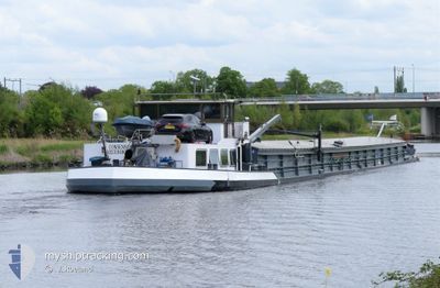
CONSENSUS
Cargo

Current Trip
HAFEN RUDOWOST TELTO
| Time Travelled | 8 days |
|---|---|
| Remaining Time | --- |
| Distance Travelled | 197.12 nm |
| Remaining Distance | --- |
| AVG Speed | 6.2 Knots |
| MAX Speed | 7.4 Knots |
| AVG Wind | 5 knots |
| MAX Wind | 12.7 knots |
| MIN Temp | 7.4°C / 45.32°F |
| MAX Temp | 18.7°C / 65.66°F |
| Draught | 1.4 m |
| Position Received | 2 h, 29 m ago |
Current Position
| Longitude | 13.08700° |
|---|---|
| Latitude | 52.41728° |
| Status | Under way using engine |
| Speed | 5.5 Knots |
| Course | 137.3° |
| Area | North Sea |
| Station | T-AIS |
| Position Received | 2 h, 29 m ago |
Information
The current position of CONSENSUS is in North Sea with coordinates 52.41728° / 13.08700° as reported on 2025-05-17 15:03 by AIS to our vessel tracker app. The vessel's current speed is 5.5 Knots
The vessel CONSENSUS (MMSI: 244660691) is a Cargo It's sailing under the flag of [NL] Netherlands.
In this page you can find informations about the vessels current position, last detected port calls, and current voyage information. If the vessels is not in coverage by AIS you will find the latest position.
The current position of CONSENSUS is detected by our AIS receivers and we are not responsible for the reliability of the data. The last position was recorded while the vessel was in Coverage by the Ais receivers of our vessel tracking app.
The current draught of CONSENSUS as reported by AIS is 1.4 meters
Weather
| Temperature | 14.1°C / 57.38°F |
|---|---|
| Wind Speed | 13 knots |
| Direction | 16° NNE |
| Pressure | 1010.8 hPa |
| Humidity | 54.2 % |
| Cloud Coverage | 100 % |


Featured Company
Last Port Calls
| Port | Arrival | Departure | Time In Port |
|---|---|---|---|
| 2025-05-09 06:42 | 2025-05-09 06:46 | 3 m | |
| 2025-05-08 16:43 | 2025-05-08 17:17 | 33 m | |
| 2025-05-07 12:41 | 2025-05-07 13:31 | 50 m | |
| 2025-05-06 17:56 | 2025-05-07 11:35 | 17 h | |
| 2025-05-05 18:01 | 2025-05-06 13:26 | 19 h | |
| 2025-05-05 13:45 | 2025-05-05 14:21 | 36 m | |
| 2025-04-30 07:49 | 2025-04-30 08:21 | 31 m | |
| 2025-04-29 11:15 | 2025-04-29 12:42 | 1 h | |
| 2025-04-29 05:30 | 2025-04-29 05:45 | 14 m | |
| 2025-04-28 13:01 | 2025-04-28 13:56 | 54 m |
Most Visited Ports (Last year)
| Port | Arrivals | |
|---|---|---|
| 16 | ||
| 11 | ||
| 9 | ||
| 8 | ||
| 7 | ||
| 6 |
Last Trips
| Origin | Departure | Destination | Arrival | Distance | |
|---|---|---|---|---|---|
| 2025-05-08 17:17 | 2025-05-09 06:42 | 30.32 nm | |||
| 2025-05-07 13:31 | 2025-05-08 16:43 | 93.84 nm | |||
| 2025-05-07 11:35 | 2025-05-07 12:41 | 8.48 nm | |||
| 2025-05-06 13:26 | 2025-05-06 17:56 | 32.99 nm | |||
| 2025-05-05 14:21 | 2025-05-05 18:01 | 30.56 nm | |||
| 2025-04-30 08:21 | 2025-05-05 13:45 | 10.86 nm | |||
| 2025-04-29 12:42 | 2025-04-30 07:49 | 75.05 nm | |||
| 2025-04-29 05:45 | 2025-04-29 11:15 | 15.18 nm | |||
| 2025-04-28 13:56 | 2025-04-29 05:30 | 0.57 nm | |||
| 2025-04-17 11:02 | 2025-04-28 13:01 | 245.18 nm |
Events
| Time | Event | Details | Position / Dest | Info |
|---|---|---|---|---|
| 2025-05-17 15:03 | OUT of Coverage |
52.41728 / 13.08700
North Sea
|
Speed: 5.5 kn Course: 137.3° |
|
| 2025-05-17 15:03 | IN Coverage |
52.41728 / 13.08700
North Sea
|
Speed: 5.5 kn Course: 137.3° |
|
| 2025-05-10 15:43 | OUT of Coverage |
52.25402 / 11.73081
North Sea
HAFEN RUDOWOST TELTO
|
Speed: 3.7 kn Course: 37.2° |
|
| 2025-05-10 14:48 | START Moving | 4.18 nm, North East of MAGDEBURG |
52.18789 / 11.68492
HAFEN RUDOWOST TELTO
|
Speed: 4.8 kn Course: 190.7° |
| 2025-05-10 14:28 | STOP Moving | 4.42 nm, North East of MAGDEBURG |
52.19190 / 11.68607
HAFEN RUDOWOST TELTO
|
Speed: Course: 511° |
| 2025-05-10 14:15 | START Moving | 5.29 nm, North of MAGDEBURG |
52.20726 / 11.68660
HAFEN RUDOWOST TELTO
|
Speed: 6.6 kn Course: 155° |
| 2025-05-10 13:40 | STOP Moving | 6.12 nm, North of MAGDEBURG |
52.22457 / 11.66848
HAFEN RUDOWOST TELTO
|
Speed: Course: 511° |
| 2025-05-10 12:53 | Status Changed | Under way using engine Default |
52.23620 / 11.54999
HAFEN RUDOWOST TELTO
|
Speed: 6.7 kn Course: 112° |
| 2025-05-10 12:48 | IN Coverage |
52.23542 / 11.55318
North Sea
HAFEN RUDOWOST TELTO
|
Speed: 6.7 kn Course: 111.9° |
|
| 2025-05-09 15:42 | OUT of Coverage |
52.40787 / 9.73899
North Sea
HAFEN RUDOWOST TELTO
|
Speed: 6.9 kn Course: 117.7° |