
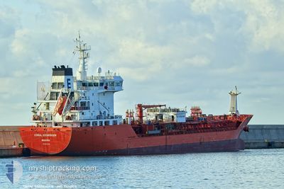
CORAL ESSBERGER
Oil/Chemical Tanker
Current Trip
| Time Travelled | 2 days |
|---|---|
| Remaining Time | --- |
| Distance Travelled | 226.47 nm |
| Remaining Distance | --- |
| AVG Speed | 10.1 Knots |
| MAX Speed | 14.3 Knots |
| AVG Wind | 15.8 knots |
| MAX Wind | 27 knots |
| MIN Temp | 1.2°C / 34.16°F |
| MAX Temp | 5.2°C / 41.36°F |
| Draught | 7.1 m |
| Position Received | 1 d ago |
Current Position
| Longitude | 1.33717° |
|---|---|
| Latitude | 53.20133° |
| Status | Under way using engine |
| Speed | 10 Knots |
| Course | 306.7° |
| Area | North Sea |
| Station | T-AIS |
| Position Received | 1 d ago |
Info
Information
The current position of CORAL ESSBERGER is in North Sea with coordinates 53.20133° / 1.33717° as reported on 2026-01-05 04:39 by AIS to our vessel tracker app. The vessel's current speed is 10 Knots
The vessel CORAL ESSBERGER (IMO: 9504205, MMSI: 255801270) is a Oil/Chemical Tanker that was built in 2012 ( 14 years old ). It's sailing under the flag of [PT] Portugal.
In this page you can find informations about the vessels current position, last detected port calls, and current voyage information. If the vessels is not in coverage by AIS you will find the latest position.
The current position of CORAL ESSBERGER is detected by our AIS receivers and we are not responsible for the reliability of the data. The last position was recorded while the vessel was in Coverage by the Ais receivers of our vessel tracking app.
The current draught of CORAL ESSBERGER as reported by AIS is 7.1 meters
Weather
| Temperature | 3.2°C / 37.76°F |
|---|---|
| Wind Speed | 19 knots |
| Direction | 210° SSW |
| Pressure | 1009 hPa |
| Humidity | 91.7 % |
| Cloud Coverage | 100 % |
Featured Company
Last Port Calls
| Port | Arrival | Departure | Time In Port |
|---|---|---|---|
| 2026-01-02 03:23 | 2026-01-04 12:43 | 2 d | |
| 2025-12-27 02:52 | 2025-12-28 16:59 | 1 d | |
| 2025-12-24 11:46 | 2025-12-24 12:59 | 1 h | |
| 2025-12-22 07:34 | 2025-12-23 00:50 | 17 h | |
| 2025-12-18 05:31 | 2025-12-19 11:37 | 1 d | |
| 2025-12-14 16:07 | 2025-12-16 17:52 | 2 d | |
| 2025-12-02 23:06 | 2025-12-12 22:46 | 9 d | |
| 2025-11-29 00:34 | 2025-11-29 01:40 | 1 h | |
| 2025-11-26 12:14 | 2025-11-28 23:13 | 2 d | |
| 2025-11-16 21:26 | 2025-11-18 16:49 | 1 d |
Last Trips
| Origin | Departure | Destination | Arrival | Distance | |
|---|---|---|---|---|---|
| 2025-12-28 16:59 | 2026-01-02 03:23 | 347.04 nm | |||
| 2025-12-24 12:59 | 2025-12-27 02:52 | 399.80 nm | |||
| 2025-12-23 00:50 | 2025-12-24 11:46 | 452.85 nm | |||
| 2025-12-19 11:37 | 2025-12-22 07:34 | 407.63 nm | |||
| 2025-12-16 17:52 | 2025-12-18 05:31 | 351.09 nm | |||
| 2025-12-12 22:46 | 2025-12-14 16:07 | 322.81 nm | |||
| 2025-11-29 01:40 | 2025-12-02 23:06 | 827.26 nm | |||
| 2025-11-28 23:13 | 2025-11-29 00:34 | 9.31 nm | |||
| 2025-11-18 16:49 | 2025-11-26 12:14 | 1633.83 nm | |||
| 2025-11-14 08:06 | 2025-11-16 21:26 | 482.75 nm |
Events
| Time | Event | Details | Position / Dest | Info |
|---|---|---|---|---|
| 2026-01-05 09:29 | STOP Moving | 18.08 nm, East of GRIMSBY |
53.58884 / .43702
GBIMM
|
Speed: 0.3 kn Course: 283° |
| 2026-01-05 04:44 | Status Changed | Default Under way using engine |
53.21177 / 1.31572
GBIMM
|
Speed: 10 kn Course: 306.7° |
| 2026-01-05 04:39 | OUT of Coverage |
53.20133 / 1.33717
North Sea
GBIMM
|
Speed: 10 kn Course: 306.7° |
|
| 2026-01-05 01:26 | Change Sea Area | United Kingdom part of the North Sea Dutch part of the North Sea |
52.85789 / 2.11855
North Sea
GBIMM
|
Speed: 11 kn Course: 317.3° |
| 2026-01-05 01:26 | Status Changed | Under way using engine Default |
52.85789 / 2.11855
GBIMM
|
Speed: 10.9 kn Course: 318° |
| 2026-01-05 01:13 | IN Coverage |
52.85789 / 2.11855
North Sea
GBIMM
|
Speed: 11 kn Course: 317.3° |
|
| 2026-01-04 20:00 | Status Changed | Default Under way using engine |
51.99737 / 2.64857
GBIMM
|
Speed: 11.1 kn Course: 302.7° |
| 2026-01-04 19:55 | OUT of Coverage |
51.98781 / 2.67199
North Sea
GBIMM
|
Speed: 11.1 kn Course: 302.7° |
|
| 2026-01-04 19:52 | Status Changed | Under way using engine Default |
51.98373 / 2.68177
GBIMM
|
Speed: 11.2 kn Course: 302° |
| 2026-01-04 19:49 | Status Changed | Default Under way using engine |
51.97740 / 2.69738
GBIMM
|
Speed: 10.7 kn Course: 312.7° |