
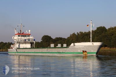
DROGDENBANK
General Cargo
Current Trip
| Time Travelled | 11 days |
|---|---|
| Remaining Time | 23 h, 31 mins |
| Distance Travelled | 1811.66 nm |
| Remaining Distance | 240.73 nm |
| AVG Speed | 9.6 Knots |
| MAX Speed | 12.6 Knots |
| AVG Wind | 19.5 knots |
| MAX Wind | 39.8 knots |
| MIN Temp | 5.2°C / 41.36°F |
| MAX Temp | 14.7°C / 58.46°F |
| Draught | 6.4 m |
| Position Received | 2 m ago |
Current Position
| Longitude | -0.66839° |
|---|---|
| Latitude | 37.44242° |
| Status | Under way using engine |
| Speed | 10.9 Knots |
| Course | 49.9° |
| Area | Mediterranean Sea - Western Basin |
| Station | T-AIS |
| Position Received | 2 m ago |
Info
Information
The current position of DROGDENBANK is in Mediterranean Sea - Western Basin with coordinates 37.44242° / -0.66839° as reported on 2025-02-04 18:37 by AIS to our vessel tracker app. The vessel's current speed is 10.9 Knots and is heading at the port of TARRAGONA. The estimated time of arrival as calculated by MyShipTracking vessel tracking app is 2025-02-05 18:11 LT
The vessel DROGDENBANK (IMO: 9474163, MMSI: 244689000) is a General Cargo that was built in 2009 ( 16 years old ). It's sailing under the flag of [NL] Netherlands.
In this page you can find informations about the vessels current position, last detected port calls, and current voyage information. If the vessels is not in coverage by AIS you will find the latest position.
The current position of DROGDENBANK is detected by our AIS receivers and we are not responsible for the reliability of the data. The last position was recorded while the vessel was in Coverage by the Ais receivers of our vessel tracking app.
The current draught of DROGDENBANK as reported by AIS is 6.4 meters
Weather
| Temperature | 13.8°C / 56.84°F |
|---|---|
| Wind Speed | 7 knots |
| Direction | 51° NE |
| Pressure | 1028.6 hPa |
| Humidity | 66.7 % |
| Cloud Coverage | 1 % |
Featured Company
Last Port Calls
| Port | Arrival | Departure | Time In Port |
|---|---|---|---|
| 2025-01-21 11:52 | 2025-01-24 02:43 | 2 d | |
| 2025-01-19 06:34 | 2025-01-20 15:04 | 1 d | |
| 2025-01-09 01:59 | 2025-01-13 18:52 | 4 d | |
| 2025-01-06 09:31 | 2025-01-08 18:38 | 2 d | |
| 2024-12-25 14:06 | 2024-12-27 01:13 | 1 d | |
| 2024-12-21 15:17 | 2024-12-23 21:12 | 2 d | |
| 2024-12-16 15:01 | 2024-12-21 09:13 | 4 d | |
| 2024-12-02 13:41 | 2024-12-11 10:44 | 8 d |
Last Trips
| Origin | Departure | Destination | Arrival | Distance | |
|---|---|---|---|---|---|
| 2025-01-20 15:04 | 2025-01-21 12:52 | 250.56 nm | |||
| 2025-01-13 19:52 | 2025-01-19 06:34 | 779.50 nm | |||
| 2025-01-08 19:38 | 2025-01-09 02:59 | 86.31 nm | |||
| 2024-12-27 02:13 | 2025-01-06 10:31 | 1761.03 nm | |||
| 2024-12-23 23:12 | 2024-12-25 15:06 | 482.83 nm | |||
| 2024-12-21 11:13 | 2024-12-21 17:17 | 70.05 nm | |||
| 2024-12-11 11:44 | 2024-12-16 17:01 | 1227.36 nm | |||
| 2024-11-27 14:36 | 2024-12-02 14:41 | 1273.51 nm |
Events
| Time | Event | Details | Position / Dest | Info |
|---|---|---|---|---|
| 2025-02-04 18:27 | Status Changed | Under way using engine Default |
37.42180 / -.69882
ESTAR
|
Speed: 10.9 kn Course: 48° |
| 2025-02-04 18:23 | Status Changed | Default Under way using engine |
37.41479 / -.70881
ESTAR
|
Speed: 10.8 kn Course: 49.1° |
| 2025-02-04 17:43 | Status Changed | Under way using engine Default |
37.33448 / -.82044
ESTAR
|
Speed: 10.8 kn Course: 48° |
| 2025-02-04 17:39 | Status Changed | Default Under way using engine |
37.32647 / -.83170
ESTAR
|
Speed: 10.8 kn Course: 48.6° |
| 2025-02-04 17:27 | Status Changed | Under way using engine Default |
37.30304 / -.86512
ESTAR
|
Speed: 10.7 kn Course: 49° |
| 2025-02-04 17:20 | Status Changed | Default Under way using engine |
37.28783 / -.88685
ESTAR
|
Speed: 10.7 kn Course: 48.6° |
| 2025-02-04 17:17 | Status Changed | Under way using engine Default |
37.28296 / -.89389
ESTAR
|
Speed: 10.9 kn Course: 49° |
| 2025-02-04 16:33 | Status Changed | Default Under way using engine |
37.19696 / -1.01764
ESTAR
|
Speed: 10.5 kn Course: 48.2° |
| 2025-02-04 16:27 | Change Sea Area | Spanish part of the Mediterranean Sea - Western Basin Spanish part of the Alboran Sea |
37.18518 / -1.03457
Mediterranean Sea - Western Basin
ESTAR
|
Speed: 10.5 kn Course: 48.2° |
| 2025-02-04 16:27 | Status Changed | Under way using engine Default |
37.18518 / -1.03457
ESTAR
|
Speed: 10.1 kn Course: 50° |