

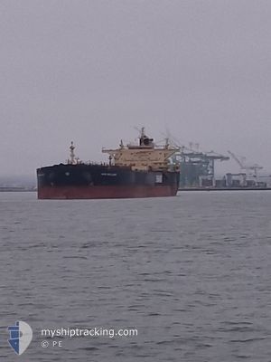
DUBAI BRILLIANCE
Crude Oil Tanker

Current Trip
| Time Travelled | 21 h, 3 mins |
|---|---|
| Remaining Time | --- |
| Distance Travelled | 31.78 nm |
| Remaining Distance | --- |
| AVG Speed | 8.8 Knots |
| MAX Speed | 10.8 Knots |
| AVG Wind | 9.2 knots |
| MAX Wind | 13.8 knots |
| MIN Temp | 12.9°C / 55.22°F |
| MAX Temp | 18.8°C / 65.84°F |
| Draught | 9.5 m |
| Position Received | 4 m ago |
Current Position
| Longitude | -122.35767° |
|---|---|
| Latitude | 37.79157° |
| Status | At anchor |
| Speed | |
| Course | 318° |
| Area | North Pacific Ocean |
| Station | T-AIS |
| Position Received | 4 m ago |
Information
The current position of DUBAI BRILLIANCE is in North Pacific Ocean with coordinates 37.79157° / -122.35767° as reported on 2025-06-09 15:01 by AIS to our vessel tracker app. The vessel's current speed is 0 Knots
The vessel DUBAI BRILLIANCE (IMO: 9422550, MMSI: 538004174) is a Crude Oil Tanker that was built in 2011 ( 14 years old ). It's sailing under the flag of [MH] Marshall Is.
In this page you can find informations about the vessels current position, last detected port calls, and current voyage information. If the vessels is not in coverage by AIS you will find the latest position.
The current position of DUBAI BRILLIANCE is detected by our AIS receivers and we are not responsible for the reliability of the data. The last position was recorded while the vessel was in Coverage by the Ais receivers of our vessel tracking app.
The current draught of DUBAI BRILLIANCE as reported by AIS is 9.5 meters
Weather
| Temperature | 13.9°C / 57.02°F |
|---|---|
| Wind Speed | 3 knots |
| Direction | 241° WSW |
| Pressure | 1014.9 hPa |
| Humidity | 83.7 % |
| Cloud Coverage | 100 % |


Featured Company
Last Port Calls
| Port | Arrival | Departure | Time In Port |
|---|---|---|---|
| 2025-06-07 10:52 | 2025-06-08 11:03 | 1 d | |
| 2025-06-05 06:07 | 2025-06-06 18:42 | 1 d | |
| 2025-05-28 20:38 | 2025-05-30 00:26 | 1 d |
Most Visited Ports (Last year)
| Port | Arrivals | |
|---|---|---|
| 3 | ||
| 2 | ||
| 2 | ||
| 2 | ||
| 1 | ||
| 1 |
Last Trips
| Origin | Departure | Destination | Arrival | Distance | |
|---|---|---|---|---|---|
| 2025-06-06 18:42 | 2025-06-07 10:52 | 50.17 nm | |||
| 2025-05-30 00:26 | 2025-06-05 06:07 | 38.53 nm | |||
| 2025-03-13 11:49 | 2025-05-28 20:38 | 9504.87 nm |
Events
| Time | Event | Details | Position / Dest | Info |
|---|---|---|---|---|
| 2025-06-09 12:49 | Status Changed | At anchor Default |
37.79536 / -122.35972
USSFO
|
Speed: 0.1 kn Course: 175° |
| 2025-06-09 12:46 | Status Changed | Default At anchor |
37.79535 / -122.35976
USSFO
|
Speed: 0.1 kn Course: 174° |
| 2025-06-09 08:13 | Status Changed | At anchor Default |
37.79550 / -122.36039
USSFO
|
Speed: 0.5 kn Course: 128° |
| 2025-06-09 08:10 | Status Changed | Default At anchor |
37.79506 / -122.36086
USSFO
|
Speed: 0.2 kn Course: 136° |
| 2025-06-08 21:34 | STOP Moving | 1.27 nm, South of TREASURE ISLAND |
37.79616 / -122.35895
USSFO
|
Speed: 0.2 kn Course: 168° |
| 2025-06-08 21:28 | Status Changed | At anchor Under way using engine |
37.79548 / -122.35908
USSFO
|
Speed: 1.3 kn Course: 156° |
| 2025-06-08 18:44 | Draught Changed | 9.5 9.1 |
38.06288 / -122.22400
USSFO
|
Speed: 8.6 kn Course: 276.6° |
| 2025-06-08 18:43 | Status Changed | Under way using engine Default |
38.06288 / -122.22400
USSFO
|
Speed: 8.5 kn Course: 282° |
| 2025-06-08 18:37 | Status Changed | Default Under way using engine |
38.05988 / -122.20589
USSFO
|
Speed: 8.5 kn Course: 290.7° |
| 2025-06-08 18:31 | Status Changed | Under way using engine Default |
38.05557 / -122.19003
USSFO
|
Speed: 9 kn Course: 313° |