
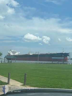
FRONT COSMOS
Tanker
Current Trip
| Time Travelled | 4 days |
|---|---|
| Remaining Time | 3 days |
| Distance Travelled | 1367.95 nm |
| Remaining Distance | 1340.05 nm |
| AVG Speed | 11.9 Knots |
| MAX Speed | 15.1 Knots |
| AVG Wind | 20 knots |
| MAX Wind | 30 knots |
| MIN Temp | 3.1°C / 37.58°F |
| MAX Temp | 12.8°C / 55.04°F |
| Draught | 9.5 m |
| Position Received | 1 d ago |
Current Position
| Longitude | -5.48095° |
|---|---|
| Latitude | 49.03258° |
| Status | Under way using engine |
| Speed | 12.4 Knots |
| Course | 240.7° |
| Area | Celtic Sea |
| Station | T-AIS |
| Position Received | 1 d ago |
Info
Information
The current position of FRONT COSMOS is in Celtic Sea with coordinates 49.03258° / -5.48095° as reported on 2025-02-08 11:59 by AIS to our vessel tracker app. The vessel's current speed is 12.4 Knots and is heading at the port of LAS PALMAS. The estimated time of arrival as calculated by MyShipTracking vessel tracking app is 2025-02-12 21:28 LT
The vessel FRONT COSMOS (IMO: 9769817, MMSI: 538007397) is a Tanker It's sailing under the flag of [MH] Marshall Is.
In this page you can find informations about the vessels current position, last detected port calls, and current voyage information. If the vessels is not in coverage by AIS you will find the latest position.
The current position of FRONT COSMOS is detected by our AIS receivers and we are not responsible for the reliability of the data. The last position was recorded while the vessel was in Coverage by the Ais receivers of our vessel tracking app.
The current draught of FRONT COSMOS as reported by AIS is 9.5 meters
Weather
| Temperature | 12.8°C / 55.04°F |
|---|---|
| Wind Speed | 5 knots |
| Direction | 304° NW |
| Pressure | 1021.1 hPa |
| Humidity | 82.9 % |
| Cloud Coverage | 100 % |
Featured Company
Last Port Calls
| Port | Arrival | Departure | Time In Port |
|---|---|---|---|
| 2025-02-03 16:05 | 2025-02-04 17:08 | 1 d | |
| 2025-01-31 18:58 | 2025-02-01 17:13 | 22 h | |
| 2025-01-06 16:35 | 2025-01-08 13:25 | 1 d | |
| 2024-12-29 20:16 | 2025-01-01 14:49 | 2 d |
Most Visited Ports (Last year)
| Port | Arrivals | |
|---|---|---|
| 2 | ||
| 2 | ||
| 2 | ||
| 2 | ||
| 1 | ||
| 1 |
Last Trips
| Origin | Departure | Destination | Arrival | Distance | |
|---|---|---|---|---|---|
| 2025-02-01 18:13 | 2025-02-03 17:05 | 12.90 nm | |||
| 2025-01-08 07:25 | 2025-01-31 19:58 | 5988.19 nm | |||
| 2025-01-01 08:49 | 2025-01-06 10:35 | 130.51 nm | |||
| 2024-11-07 07:36 | 2024-12-29 14:16 | 6988.72 nm |
Events
| Time | Event | Details | Position / Dest | Info |
|---|---|---|---|---|
| 2025-02-08 12:00 | Status Changed | Default Under way using engine |
49.03002 / -5.48768
ESLPA
|
Speed: 12.4 kn Course: 240.7° |
| 2025-02-08 11:59 | OUT of Coverage |
49.03258 / -5.48095
Celtic Sea
ESLPA
|
Speed: 12.4 kn Course: 240.7° |
|
| 2025-02-08 10:04 | Status Changed | Under way using engine Default |
49.20979 / -5.05901
ESLPA
|
Speed: 9.4 kn Course: 234° |
| 2025-02-08 09:59 | Status Changed | Default Under way using engine |
49.21783 / -5.04197
ESLPA
|
Speed: 9.3 kn Course: 234.1° |
| 2025-02-08 09:58 | Status Changed | Under way using engine Default |
49.21884 / -5.03973
ESLPA
|
Speed: 10.2 kn Course: 234° |
| 2025-02-08 09:58 | Change Sea Area | French part of the Celtic Sea French part of the English Channel |
49.21884 / -5.03973
Celtic Sea
ESLPA
|
Speed: 9.3 kn Course: 234.1° |
| 2025-02-08 09:48 | Status Changed | Default Under way using engine |
49.23535 / -5.00461
ESLPA
|
Speed: 11 kn Course: 234.6° |
| 2025-02-08 09:19 | Detected in Sea | French part of the English Channel |
49.29025 / -4.88641
English Channel
ESLPA
|
Speed: 13.1 kn Course: 234.8° |
| 2025-02-08 09:19 | Status Changed | Under way using engine Default |
49.29025 / -4.88641
ESLPA
|
Speed: 13 kn Course: 235° |
| 2025-02-08 09:03 | IN Coverage |
49.29025 / -4.88641
English Channel
ESLPA
|
Speed: 13.1 kn Course: 234.8° |