
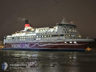
GABRIELLA
Ro-Ro/Passenger Ship
Current Trip
| Time Travelled | 10 h, 9 mins |
|---|---|
| Remaining Time | 12 mins |
| Distance Travelled | 175.91 nm |
| Remaining Distance | 9.29 nm |
| AVG Speed | 17.7 Knots |
| MAX Speed | 18.2 Knots |
| AVG Wind | 18.5 knots |
| MAX Wind | 20.7 knots |
| MIN Temp | 5.5°C / 41.9°F |
| MAX Temp | 6.2°C / 43.16°F |
| Draught | 6.4 m |
| Position Received | 5 m ago |
Current Position
| Longitude | 24.97062° |
|---|---|
| Latitude | 60.08170° |
| Status | Under way using engine |
| Speed | 15 Knots |
| Course | 12.5° |
| Area | Gulf of Finland |
| Station | T-AIS |
| Position Received | 5 m ago |
Info
Information
The current position of GABRIELLA is in Gulf of Finland with coordinates 60.08170° / 24.97062° as reported on 2025-12-16 07:33 by AIS to our vessel tracker app. The vessel's current speed is 15 Knots and is heading at the port of HELSINKI. The estimated time of arrival as calculated by MyShipTracking vessel tracking app is 2025-12-16 09:51 LT
The vessel GABRIELLA (IMO: 8917601, MMSI: 230361000) is a Ro-Ro/Passenger Ship that was built in 1992 ( 33 years old ). It's sailing under the flag of [FI] Finland.
In this page you can find informations about the vessels current position, last detected port calls, and current voyage information. If the vessels is not in coverage by AIS you will find the latest position.
The current position of GABRIELLA is detected by our AIS receivers and we are not responsible for the reliability of the data. The last position was recorded while the vessel was in Coverage by the Ais receivers of our vessel tracking app.
The current draught of GABRIELLA as reported by AIS is 6.4 meters
Weather
| Temperature | 5.5°C / 41.9°F |
|---|---|
| Wind Speed | 18 knots |
| Direction | 245° WSW |
| Pressure | 1010.8 hPa |
| Humidity | 96 % |
| Cloud Coverage | 100 % |
Featured Company
Last Port Calls
| Port | Arrival | Departure | Time In Port |
|---|---|---|---|
| 2025-12-15 23:10 | 2025-12-15 23:30 | 19 m | |
| 2025-12-15 09:34 | 2025-12-15 16:36 | 7 h | |
| 2025-12-15 04:14 | 2025-12-15 04:34 | 19 m | |
| 2025-12-14 09:53 | 2025-12-14 17:17 | 7 h | |
| 2025-12-13 23:13 | 2025-12-13 23:33 | 20 m | |
| 2025-12-13 09:33 | 2025-12-13 16:39 | 7 h | |
| 2025-12-13 04:13 | 2025-12-13 04:33 | 19 m | |
| 2025-12-12 09:54 | 2025-12-12 17:18 | 7 h | |
| 2025-12-11 23:09 | 2025-12-11 23:29 | 20 m | |
| 2025-12-11 09:37 | 2025-12-11 16:35 | 6 h |
Most Visited Ports (Last year)
| Port | Arrivals | |
|---|---|---|
| 344 | ||
| 210 | ||
| 172 | ||
| 36 | ||
| 3 |
Last Trips
| Origin | Departure | Destination | Arrival | Distance | |
|---|---|---|---|---|---|
| 2025-12-15 16:36 | 2025-12-15 23:10 | 79.83 nm | |||
| 2025-12-15 04:34 | 2025-12-15 09:34 | 78.03 nm | |||
| 2025-12-14 17:17 | 2025-12-15 04:14 | 183.68 nm | |||
| 2025-12-13 23:33 | 2025-12-14 09:53 | 183.14 nm | |||
| 2025-12-13 16:39 | 2025-12-13 23:13 | 77.10 nm | |||
| 2025-12-13 04:33 | 2025-12-13 09:33 | 78.15 nm | |||
| 2025-12-12 17:18 | 2025-12-13 04:13 | 183.85 nm | |||
| 2025-12-11 23:29 | 2025-12-12 09:54 | 183.27 nm | |||
| 2025-12-11 16:35 | 2025-12-11 23:09 | 78.63 nm | |||
| 2025-12-11 04:33 | 2025-12-11 09:37 | 78.18 nm |
Events
| Time | Event | Details | Position / Dest | Info |
|---|---|---|---|---|
| 2025-12-16 03:45 | Change Sea Area | Finnish part of the Gulf of Finland Finnish part of the Baltic Sea |
59.66799 / 23.03316
Gulf of Finland
SESTO-FIMHQ-FIHEL
|
Speed: 17.8 kn Course: 79.5° |
| 2025-12-16 00:02 | Status Changed | Under way using engine Default |
59.62016 / 20.90186
SESTO-FIMHQ-FIHEL
|
Speed: 17.9 kn Course: 104° |
| 2025-12-15 23:54 | Status Changed | Default Under way using engine |
59.62933 / 20.82108
SESTO-FIMHQ-FIHEL
|
Speed: 17.8 kn Course: 102.7° |
| 2025-12-15 23:34 | Change Sea Area | Finnish part of the Baltic Sea Finnish part of the Gulf of Bothnia |
59.65143 / 20.62934
Baltic Sea
SESTO-FIMHQ-FIHEL
|
Speed: 18.1 kn Course: 107.8° |
| 2025-12-15 23:34 | IN Coverage |
59.65143 / 20.62934
Baltic Sea
SESTO-FIMHQ-FIHEL
|
Speed: 18.1 kn Course: 107.8° |
|
| 2025-12-15 23:34 | Status Changed | Under way using engine Default |
59.65174 / 20.62747
SESTO-FIMHQ-FIHEL
|
Speed: 18 kn Course: 122° |
| 2025-12-15 21:42 | Status Changed | Default Under way using engine |
60.02599 / 19.89355
SESTO-FIMHQ-FIHEL
|
Speed: 16 kn Course: 209.2° |
| 2025-12-15 21:37 | OUT of Coverage |
60.04887 / 19.89663
Gulf of Bothnia
SESTO-FIMHQ-FIHEL
|
Speed: 16 kn Course: 209.2° |
|
| 2025-12-15 21:35 | Status Changed | Under way using engine Default |
60.05475 / 19.90295
SESTO-FIMHQ-FIHEL
|
Speed: 14.7 kn Course: 210° |
| 2025-12-15 21:30 | PORT DEPARTURE |
|
60.07496 / 19.92388
SESTO-FIMHQ-FIHEL
|
Speed: 9.8 kn Course: 182° |