
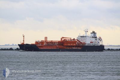
GAZ EXPLORER
Lpg Tanker
Current Trip
| Trip Time | --- |
|---|---|
| Trip Distance | --- |
| AVG Speed | --- |
| MAX Speed | --- |
| Draught | --- |
| AVG Wind | --- |
| MAX Wind | --- |
| MIN Temp | --- |
| MAX Temp | --- |
| Position Received | 7 d ago |
Current Position
| Longitude | 29.26187° |
|---|---|
| Latitude | 41.49962° |
| Status | Under way using engine |
| Speed | 14.1 Knots |
| Course | 11.4° |
| Area | Black Sea |
| Station | T-AIS |
| Position Received | 7 d ago |
Info
Information
The current position of GAZ EXPLORER is in Black Sea with coordinates 41.49962° / 29.26187° as reported on 2026-01-02 17:03 by AIS to our vessel tracker app. The vessel's current speed is 14.1 Knots and is currently inside the port of GALATI.
The vessel GAZ EXPLORER (IMO: 9506150, MMSI: 354588000) is a Lpg Tanker that was built in 2010 ( 16 years old ). It's sailing under the flag of [PA] Panama.
In this page you can find informations about the vessels current position, last detected port calls, and current voyage information. If the vessels is not in coverage by AIS you will find the latest position.
The current position of GAZ EXPLORER is detected by our AIS receivers and we are not responsible for the reliability of the data. The last position was recorded while the vessel was in Coverage by the Ais receivers of our vessel tracking app.
The current draught of GAZ EXPLORER as reported by AIS is 7 meters
Weather
| Temperature | -0.5°C / 31.1°F |
|---|---|
| Wind Speed | 13 knots |
| Direction | 212° SSW |
| Pressure | 1005.3 hPa |
| Humidity | 62.3 % |
| Cloud Coverage | --- |
Featured Company
Last Port Calls
| Port | Arrival | Departure | Time In Port |
|---|---|---|---|
| 2026-01-04 11:04 | 2026-01-04 11:35 | 30 m | |
| 2026-01-02 17:30 | 2026-01-02 18:40 | 1 h | |
| 2025-12-27 16:36 | 2025-12-30 13:04 | 2 d | |
| 2025-12-17 20:38 | |||
| 2025-12-10 17:25 | 2025-12-11 17:33 | 1 d | |
| 2025-12-05 08:37 | 2025-12-06 13:45 | 1 d | |
| 2025-11-23 14:49 | 2025-11-23 14:56 | 7 m | |
| 2025-11-17 11:36 |
Last Trips
| Origin | Departure | Destination | Arrival | Distance | |
|---|---|---|---|---|---|
| 2026-01-02 18:40 | 2026-01-04 11:04 | 258.26 nm | |||
| 2025-12-30 13:04 | 2026-01-02 17:30 | 781.44 nm | |||
| 2025-12-17 20:38 | 2025-12-27 16:36 | 442.19 nm | |||
| 2025-12-06 13:45 | 2025-12-10 17:25 | 6.37 nm | |||
| 2025-11-23 14:56 | 2025-12-05 08:37 | 1209.99 nm | |||
| 2025-11-17 11:36 | 2025-11-23 14:49 | 918.84 nm |
Events
| Time | Event | Details | Position / Dest | Info |
|---|---|---|---|---|
| 2026-01-04 09:35 | PORT DEPARTURE |
|
45.16658 / 29.58558
SULINA
|
Speed: 6 kn Course: 293° |
| 2026-01-04 09:04 | PORT ARRIVAL |
|
45.15733 / 29.66011
[RO] SULINA
|
Speed: 8 kn Course: 252° |
| 2026-01-04 08:47 | START Moving | 2.5 nm, East of SULINA |
45.16557 / 29.70567
SULINA
|
Speed: 6.6 kn Course: 263° |
| 2026-01-04 05:56 | STOP Moving | 2.85 nm, East of SULINA |
45.16559 / 29.71386
SULINA
|
Speed: 0.3 kn Course: 268° |
| 2026-01-04 04:27 | START Moving | 8.66 nm, South East of SULINA |
45.04821 / 29.78136
SULINA
|
Speed: 4 kn Course: 6° |
| 2026-01-03 09:45 | STOP Moving | 8.82 nm, South East of SULINA |
45.04870 / 29.78753
SULINA
|
Speed: Course: 218° |
| 2026-01-02 17:08 | Status Changed | Default Under way using engine |
41.51433 / 29.26567
SULINA
|
Speed: 14.1 kn Course: 11.4° |
| 2026-01-02 17:03 | OUT of Coverage |
41.49962 / 29.26187
Black Sea
SULINA
|
Speed: 14.1 kn Course: 11.4° |
|
| 2026-01-02 16:59 | Status Changed | Under way using engine Default |
41.48609 / 29.25848
SULINA
|
Speed: 14.3 kn Course: 10° |
| 2026-01-02 16:56 | Status Changed | Default Under way using engine |
41.47512 / 29.25592
SULINA
|
Speed: 14.3 kn Course: 10° |