

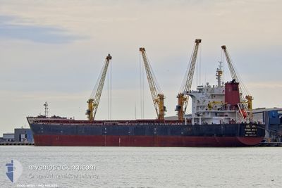
GOOD WISH
Bulk Carrier

Current Trip
| Time Travelled | 20 days |
|---|---|
| Remaining Time | --- |
| Distance Travelled | 5129.66 nm |
| Remaining Distance | --- |
| AVG Speed | 10.5 Knots |
| MAX Speed | 12.7 Knots |
| AVG Wind | 12 knots |
| MAX Wind | 36.8 knots |
| MIN Temp | 14.3°C / 57.74°F |
| MAX Temp | 28.6°C / 83.48°F |
| Draught | 12.8 m |
| Position Received | 4 d ago |
Current Position
| Longitude | 31.09786° |
|---|---|
| Latitude | -31.25061° |
| Status | Under way using engine |
| Speed | 10 Knots |
| Course | 53.2° |
| Area | Indian Ocean |
| Station | T-AIS |
| Position Received | 4 d ago |
Information
The current position of GOOD WISH is in Indian Ocean with coordinates -31.25061° / 31.09786° as reported on 2025-05-23 14:32 by AIS to our vessel tracker app. The vessel's current speed is 10 Knots and is heading at the port of JAIGAD. The estimated time of arrival as calculated by MyShipTracking vessel tracking app is 2025-06-07 11:00 LT
The vessel GOOD WISH (IMO: 9502623, MMSI: 636015288) is a Bulk Carrier that was built in 2011 ( 14 years old ). It's sailing under the flag of [LR] Liberia.
In this page you can find informations about the vessels current position, last detected port calls, and current voyage information. If the vessels is not in coverage by AIS you will find the latest position.
The current position of GOOD WISH is detected by our AIS receivers and we are not responsible for the reliability of the data. The last position was recorded while the vessel was in Coverage by the Ais receivers of our vessel tracking app.
The current draught of GOOD WISH as reported by AIS is 12.8 meters
Weather
| Temperature | 26.7°C / 80.06°F |
|---|---|
| Wind Speed | 17 knots |
| Direction | 206° SSW |
| Pressure | 1019.4 hPa |
| Humidity | 69.1 % |
| Cloud Coverage | --- |


Featured Company
Last Port Calls
| Port | Arrival | Departure | Time In Port |
|---|---|---|---|
| 2025-05-05 14:48 | 2025-05-07 16:27 | 2 d | |
| 2025-04-25 11:59 | 2025-04-28 12:57 | 3 d | |
| 2025-04-22 20:49 | 2025-04-23 07:00 | 10 h | |
| 2025-04-08 18:43 | 2025-04-10 07:14 | 1 d | |
| 2025-03-21 06:48 | 2025-03-25 14:39 | 4 d | |
| 2025-03-06 12:56 | 2025-03-08 03:57 | 1 d | |
| 2025-03-03 21:09 | 2025-03-04 07:24 | 10 h |
Most Visited Ports (Last year)
| Port | Arrivals | |
|---|---|---|
| 4 | ||
| 1 | ||
| 1 | ||
| 1 | ||
| 1 | ||
| 1 |
Last Trips
| Origin | Departure | Destination | Arrival | Distance | |
|---|---|---|---|---|---|
| 2025-04-28 13:57 | 2025-05-05 14:48 | 1709.77 nm | |||
| 2025-04-23 08:00 | 2025-04-25 12:59 | 468.97 nm | |||
| 2025-04-10 03:14 | 2025-04-22 21:49 | 3125.76 nm | |||
| 2025-03-25 15:39 | 2025-04-08 14:43 | 3479.74 nm | |||
| 2025-03-07 22:57 | 2025-03-21 07:48 | 3260.53 nm | |||
| 2025-03-04 02:24 | 2025-03-06 07:56 | 54.95 nm | |||
| 2025-02-07 12:38 | 2025-03-03 16:09 | 92.34 nm |
Events
| Time | Event | Details | Position / Dest | Info |
|---|---|---|---|---|
| 2025-05-23 14:36 | Status Changed | Default Under way using engine |
-31.24304 / 31.10955
JAIGARH
|
Speed: 10 kn Course: 53.2° |
| 2025-05-23 14:32 | OUT of Coverage |
-31.25061 / 31.09786
Indian Ocean
JAIGARH
|
Speed: 10 kn Course: 53.2° |
|
| 2025-05-23 14:31 | Detected in Sea | South African part of the Indian Ocean |
-31.25202 / 31.09564
Indian Ocean
JAIGARH
|
Speed: 9.8 kn Course: 52.2° |
| 2025-05-23 14:31 | Status Changed | Under way using engine Default |
-31.25202 / 31.09564
JAIGARH
|
Speed: 10.1 kn Course: 51° |
| 2025-05-23 14:22 | IN Coverage |
-31.25202 / 31.09564
Indian Ocean
JAIGARH
|
Speed: 9.8 kn Course: 52.2° |
|
| 2025-05-20 18:17 | Status Changed | Default Under way using engine |
-34.32392 / 18.06619
JAIGARH
|
Speed: 9.4 kn Course: 119.6° |
| 2025-05-20 18:12 | OUT of Coverage |
-34.31766 / 18.05278
South Atlantic Ocean
JAIGARH
|
Speed: 9.4 kn Course: 119.6° |
|
| 2025-05-20 18:07 | Draught Changed | 12.8 6.8 |
-34.30862 / 18.03349
JAIGARH
|
Speed: 9.2 kn Course: 119.4° |
| 2025-05-20 18:07 | Destination Changed | JAIGARH KAMSAR |
-34.30862 / 18.03349
JAIGARH
|
Speed: 9.2 kn Course: 119.4° |
| 2025-05-20 18:07 | ETA Changed | 2025/06/07 11:00 2025/05/05 16:00 |
-34.30862 / 18.03349
JAIGARH
|
Speed: 9.2 kn Course: 119.4° |