
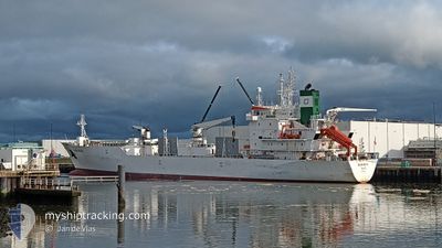
GREEN BRAZIL
Cargo
Current Trip
US DUT
| Time Travelled | 4 days |
|---|---|
| Remaining Time | --- |
| Distance Travelled | 1119.28 nm |
| Remaining Distance | --- |
| AVG Speed | 10.1 Knots |
| MAX Speed | 15.8 Knots |
| AVG Wind | 19.4 knots |
| MAX Wind | 30.9 knots |
| MIN Temp | 4.6°C / 40.28°F |
| MAX Temp | 7.8°C / 46.04°F |
| Draught | 7 m |
| Position Received | 19 d ago |
Current Position
| Longitude | 141.12550° |
|---|---|
| Latitude | 34.61033° |
| Status | Under way using engine |
| Speed | 16.1 Knots |
| Course | 94° |
| Area | North Pacific Ocean |
| Station | T-AIS |
| Position Received | 19 d ago |
Info
Information
The current position of GREEN BRAZIL is in North Pacific Ocean with coordinates 34.61033° / 141.12550° as reported on 2025-01-24 02:00 by AIS to our vessel tracker app. The vessel's current speed is 16.1 Knots
The vessel GREEN BRAZIL (IMO: 904579200, MMSI: 309681000) is a Cargo It's sailing under the flag of [BS] Bahamas.
In this page you can find informations about the vessels current position, last detected port calls, and current voyage information. If the vessels is not in coverage by AIS you will find the latest position.
The current position of GREEN BRAZIL is detected by our AIS receivers and we are not responsible for the reliability of the data. The last position was recorded while the vessel was in Coverage by the Ais receivers of our vessel tracking app.
The current draught of GREEN BRAZIL as reported by AIS is 7 meters
Weather
| Temperature | 7.1°C / 44.78°F |
|---|---|
| Wind Speed | 17 knots |
| Direction | 88° E |
| Pressure | 1000.5 hPa |
| Humidity | 94.7 % |
| Cloud Coverage | 100 % |
Featured Company
Last Port Calls
| Port | Arrival | Departure | Time In Port |
|---|---|---|---|
| 2025-02-06 05:07 | 2025-02-08 09:43 | 2 d | |
| 2025-02-04 10:47 | 2025-02-06 01:27 | 1 d | |
| 2025-02-04 05:43 | 2025-02-04 07:19 | 1 h | |
| 2025-01-22 00:17 | 2025-01-23 07:35 | 1 d | |
| 2025-01-19 01:11 | 2025-01-20 22:14 | 1 d | |
| 2024-12-26 03:05 | 2024-12-26 18:31 | 15 h | |
| 2024-12-18 07:55 | 2024-12-23 18:27 | 5 d | |
| 2024-12-04 13:38 | 2024-12-08 08:46 | 3 d |
Most Visited Ports (Last year)
| Port | Arrivals | |
|---|---|---|
| 4 | ||
| 2 | ||
| 2 | ||
| 2 | ||
| 1 | ||
| 1 |
Last Trips
| Origin | Departure | Destination | Arrival | Distance | |
|---|---|---|---|---|---|
| 2025-02-05 16:27 | 2025-02-05 20:07 | 50.74 nm | |||
| 2025-02-03 22:19 | 2025-02-04 01:47 | 49.66 nm | |||
| 2025-01-23 16:35 | 2025-02-03 20:43 | 3608.89 nm | |||
| 2025-01-21 07:14 | 2025-01-22 09:17 | 351.85 nm | |||
| 2024-12-23 21:27 | 2025-01-19 10:11 | 8443.39 nm | |||
| 2024-12-23 21:27 | 2024-12-26 05:05 | 424.23 nm | |||
| 2024-12-08 08:46 | 2024-12-18 10:55 | 3598.70 nm | |||
| 2024-11-27 03:12 | 2024-12-04 13:38 | 2589.84 nm |
Events
| Time | Event | Details | Position / Dest | Info |
|---|---|---|---|---|
| 2025-02-08 09:43 | PORT DEPARTURE |
|
53.91410 / -166.48451
US DUT
|
Speed: 10 kn Course: 42° |
| 2025-02-08 09:23 | START Moving |
53.90765 / -166.51321
[US] DUTCH HARBOR
|
Speed: 5.1 kn Course: 206° |
|
| 2025-02-06 05:43 | STOP Moving |
53.91064 / -166.51144
[US] DUTCH HARBOR
|
Speed: Course: 216° |
|
| 2025-02-06 05:07 | PORT ARRIVAL |
|
53.90606 / -166.49014
[US] DUTCH HARBOR
|
Speed: 12.5 kn Course: 187° |
| 2025-02-06 01:43 | START Moving | 0.17 nm, South of AKUTAN |
54.12922 / -165.78003
US DUT
|
Speed: 5.9 kn Course: 86° |
| 2025-02-06 01:27 | PORT DEPARTURE |
|
54.12926 / -165.78067
US DUT
|
Speed: Course: 260° |
| 2025-02-04 10:50 | STOP Moving |
54.13193 / -165.78218
[US] AKUTAN
|
Speed: 0.2 kn Course: 260° |
|
| 2025-02-04 10:47 | PORT ARRIVAL |
|
54.13191 / -165.78212
[US] AKUTAN
|
Speed: 0.9 kn Course: 265° |
| 2025-02-04 07:19 | PORT DEPARTURE |
|
53.91285 / -166.48497
US DUT
|
Speed: 9.7 kn Course: 40° |
| 2025-02-04 07:07 | START Moving |
53.89301 / -166.51987
[US] DUTCH HARBOR
|
Speed: 6.4 kn Course: 106° |