

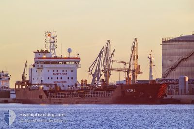
HITRA
Oil/Chemical Tanker

Current Trip
| Time Travelled | 3 days |
|---|---|
| Remaining Time | --- |
| Distance Travelled | 973.30 nm |
| Remaining Distance | --- |
| AVG Speed | 10.7 Knots |
| MAX Speed | 12.4 Knots |
| AVG Wind | 10.3 knots |
| MAX Wind | 21.2 knots |
| MIN Temp | 16.2°C / 61.16°F |
| MAX Temp | 20.4°C / 68.72°F |
| Draught | 6.6 m |
| Position Received | 20 m ago |
Current Position
| Longitude | 12.20762° |
|---|---|
| Latitude | 37.53444° |
| Status | Under way using engine |
| Speed | 10.1 Knots |
| Course | 125.4° |
| Area | Mediterranean Sea - Eastern Basin |
| Station | T-AIS |
| Position Received | 20 m ago |
Information
The current position of HITRA is in Mediterranean Sea - Eastern Basin with coordinates 37.53444° / 12.20762° as reported on 2025-05-21 10:46 by AIS to our vessel tracker app. The vessel's current speed is 10.1 Knots
The vessel HITRA (IMO: 9413652, MMSI: 249421000) is a Oil/Chemical Tanker that was built in 2009 ( 16 years old ). It's sailing under the flag of [MT] Malta.
In this page you can find informations about the vessels current position, last detected port calls, and current voyage information. If the vessels is not in coverage by AIS you will find the latest position.
The current position of HITRA is detected by our AIS receivers and we are not responsible for the reliability of the data. The last position was recorded while the vessel was in Coverage by the Ais receivers of our vessel tracking app.
The current draught of HITRA as reported by AIS is 6.6 meters
Weather
| Temperature | 18.6°C / 65.48°F |
|---|---|
| Wind Speed | 11 knots |
| Direction | 288° WNW |
| Pressure | 1017.3 hPa |
| Humidity | 84.4 % |
| Cloud Coverage | 37 % |


Featured Company
Last Port Calls
| Port | Arrival | Departure | Time In Port |
|---|---|---|---|
| 2025-05-16 20:10 | 2025-05-17 18:39 | 22 h | |
| 2025-05-14 18:28 | 2025-05-14 22:35 | 4 h | |
| 2025-05-10 20:56 | 2025-05-11 23:33 | 1 d | |
| 2025-05-04 08:22 | 2025-05-05 22:10 | 1 d | |
| 2025-04-28 11:51 | 2025-04-30 03:43 | 1 d | |
| 2025-04-25 23:15 | 2025-04-27 14:42 | 1 d | |
| 2025-04-18 13:08 | 2025-04-19 14:00 | 1 d | |
| 2025-04-14 02:06 | 2025-04-14 07:50 | 5 h | |
| 2025-04-11 07:28 | 2025-04-12 04:17 | 20 h | |
| 2025-04-03 14:14 | 2025-04-08 10:18 | 4 d |
Most Visited Ports (Last year)
| Port | Arrivals | |
|---|---|---|
| 9 | ||
| 6 | ||
| 4 | ||
| 3 | ||
| 3 | ||
| 3 |
Last Trips
| Origin | Departure | Destination | Arrival | Distance | |
|---|---|---|---|---|---|
| 2025-05-14 22:35 | 2025-05-16 20:10 | 128.98 nm | |||
| 2025-05-11 23:33 | 2025-05-14 18:28 | 556.93 nm | |||
| 2025-05-05 22:10 | 2025-05-10 20:56 | 390.31 nm | |||
| 2025-04-30 03:43 | 2025-05-04 08:22 | 955.11 nm | |||
| 2025-04-27 14:42 | 2025-04-28 11:51 | 131.53 nm | |||
| 2025-04-19 14:00 | 2025-04-25 23:15 | 1631.04 nm | |||
| 2025-04-14 07:50 | 2025-04-18 13:08 | 129.46 nm | |||
| 2025-04-12 04:17 | 2025-04-14 02:06 | 503.48 nm | |||
| 2025-04-08 10:18 | 2025-04-11 07:28 | 758.23 nm | |||
| 2025-04-01 02:52 | 2025-04-03 14:14 | 632.77 nm |
Events
| Time | Event | Details | Position / Dest | Info |
|---|---|---|---|---|
| 2025-05-21 10:46 | Status Changed | Default Under way using engine |
37.53331 / 12.20965
GRASS
|
Speed: 10.1 kn Course: 125.4° |
| 2025-05-21 10:46 | Status Changed | Under way using engine Default |
37.53444 / 12.20762
GRASS
|
Speed: 10.1 kn Course: 124° |
| 2025-05-21 10:42 | Status Changed | Default Under way using engine |
37.54027 / 12.19699
GRASS
|
Speed: 10 kn Course: 120.5° |
| 2025-05-21 10:39 | Status Changed | Under way using engine Default |
37.54476 / 12.18881
GRASS
|
Speed: 10.1 kn Course: 127° |
| 2025-05-21 10:38 | Status Changed | Default Under way using engine |
37.54609 / 12.18640
GRASS
|
Speed: 10.1 kn Course: 122.8° |
| 2025-05-21 10:13 | Detected in Sea | Italian part of the Mediterranean Sea - Eastern Basin |
37.58618 / 12.11105
Mediterranean Sea - Eastern Basin
GRASS
|
Speed: 10.3 kn Course: 121.8° |
| 2025-05-21 08:56 | Status Changed | Under way using engine Default |
37.71211 / 11.87597
GRASS
|
Speed: 10.5 kn Course: 121° |
| 2025-05-21 08:18 | Status Changed | Default Under way using engine |
37.77050 / 11.74933
GRASS
|
Speed: 11 kn Course: 121.6° |
| 2025-05-21 08:05 | Change Sea Area | Italian part of the Mediterranean Sea - Western Basin Algerian part of the Mediterranean Sea - Western Basin |
37.78875 / 11.70862
Mediterranean Sea - Western Basin
GRASS
|
Speed: 10.8 kn Course: 118.4° |
| 2025-05-21 08:05 | Status Changed | Under way using engine Default |
37.78875 / 11.70862
GRASS
|
Speed: 10.8 kn Course: 113° |