

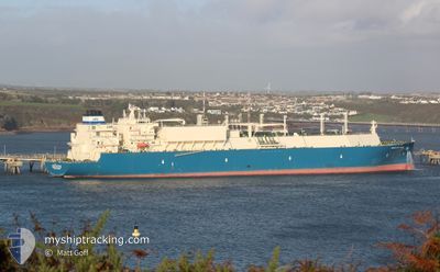
MARAN GAS ITHACA
Tanker
Current Trip
| Time Travelled | 13 days |
|---|---|
| Remaining Time | 16 h, 22 mins |
| Distance Travelled | 4894.77 nm |
| Remaining Distance | 231.36 nm |
| AVG Speed | 15.2 Knots |
| MAX Speed | 20.3 Knots |
| AVG Wind | 12.2 knots |
| MAX Wind | 34 knots |
| MIN Temp | 13.6°C / 56.48°F |
| MAX Temp | 28.7°C / 83.66°F |
| Draught | 11.3 m |
| Position Received | 2 m ago |
Current Position
| Longitude | -0.70938° |
|---|---|
| Latitude | 50.16387° |
| Status | Under way using engine |
| Speed | 14.2 Knots |
| Course | 90.6° |
| Area | English Channel |
| Station | T-AIS |
| Position Received | 2 m ago |
Information
The current position of MARAN GAS ITHACA is in English Channel with coordinates 50.16387° / -0.70938° as reported on 2025-06-10 02:31 by AIS to our vessel tracker app. The vessel's current speed is 14.2 Knots and is heading at the port of ROTTERDAM. The estimated time of arrival as calculated by MyShipTracking vessel tracking app is 2025-06-10 20:55 LT
The vessel MARAN GAS ITHACA (IMO: 9892717, MMSI: 241745000) is a Tanker It's sailing under the flag of [GR] Greece.
In this page you can find informations about the vessels current position, last detected port calls, and current voyage information. If the vessels is not in coverage by AIS you will find the latest position.
The current position of MARAN GAS ITHACA is detected by our AIS receivers and we are not responsible for the reliability of the data. The last position was recorded while the vessel was in Coverage by the Ais receivers of our vessel tracking app.
The current draught of MARAN GAS ITHACA as reported by AIS is 11.3 meters
Weather
| Temperature | 13.7°C / 56.66°F |
|---|---|
| Wind Speed | 16 knots |
| Direction | 251° WSW |
| Pressure | 1019.2 hPa |
| Humidity | 89.5 % |
| Cloud Coverage | 95 % |
Featured Company
Last Port Calls
| Port | Arrival | Departure | Time In Port |
|---|---|---|---|
| 2025-05-26 06:56 | 2025-05-27 15:28 | 1 d | |
| 2025-05-09 06:28 | 2025-05-10 05:52 | 23 h |
Most Visited Ports (Last year)
| Port | Arrivals | |
|---|---|---|
| 5 | ||
| 3 | ||
| 1 | ||
| 1 |
Last Trips
| Origin | Departure | Destination | Arrival | Distance | |
|---|---|---|---|---|---|
| 2025-05-10 05:52 | 2025-05-26 06:56 | 4950.02 nm | |||
| 2025-03-26 13:25 | 2025-05-09 06:28 | 12983.06 nm |
Events
| Time | Event | Details | Position / Dest | Info |
|---|---|---|---|---|
| 2025-06-10 01:46 | Status Changed | Under way using engine Default |
50.15042 / -.97703
NL RTM
|
Speed: 13.7 kn Course: 80° |
| 2025-06-10 01:41 | Status Changed | Default Under way using engine |
50.14674 / -1.01118
NL RTM
|
Speed: 13.8 kn Course: 80.2° |
| 2025-06-10 01:34 | Change Sea Area | United Kingdom part of the English Channel French part of the English Channel |
50.14202 / -1.05321
English Channel
NL RTM
|
Speed: 13.7 kn Course: 79.7° |
| 2025-06-10 01:34 | Status Changed | Under way using engine Default |
50.14202 / -1.05321
NL RTM
|
Speed: 13.6 kn Course: 80° |
| 2025-06-10 01:21 | Status Changed | Default Under way using engine |
50.13221 / -1.12718
NL RTM
|
Speed: 13.8 kn Course: 77.9° |
| 2025-06-10 01:10 | Status Changed | Under way using engine Default |
50.12359 / -1.19222
NL RTM
|
Speed: 13.7 kn Course: 78° |
| 2025-06-10 01:09 | Status Changed | Default Under way using engine |
50.12293 / -1.19706
NL RTM
|
Speed: 13.7 kn Course: 77.6° |
| 2025-06-10 01:01 | Status Changed | Under way using engine Default |
50.11698 / -1.24003
NL RTM
|
Speed: 13.8 kn Course: 76° |
| 2025-06-10 00:57 | Status Changed | Default Under way using engine |
50.11290 / -1.26778
NL RTM
|
Speed: 13.6 kn Course: 73.2° |
| 2025-06-10 00:50 | Status Changed | Under way using engine Default |
50.10563 / -1.30667
NL RTM
|
Speed: 13.6 kn Course: 73° |