

MILA
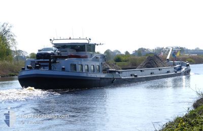
Cargo

Current Trip
| Time Travelled | 1 day |
|---|---|
| Remaining Time | 2 h, 9 mins |
| Distance Travelled | 117.35 nm |
| Remaining Distance | 18.96 nm |
| AVG Speed | 7.4 Knots |
| MAX Speed | 10 Knots |
| AVG Wind | 10.2 knots |
| MAX Wind | 17.4 knots |
| MIN Temp | 4.4°C / 39.92°F |
| MAX Temp | 13.9°C / 57.02°F |
| Draught | 3.2 m |
| Position Received | 1 m ago |
Current Position
| Longitude | 4.96484° |
|---|---|
| Latitude | 52.37863° |
| Status | Under way using engine |
| Speed | 2.2 Knots |
| Course | --- |
| Area | North Sea |
| Station | T-AIS |
| Position Received | 1 m ago |
Information
The current position of MILA is in North Sea with coordinates 52.37863° / 4.96484° as reported on 2025-05-06 17:39 by AIS to our vessel tracker app. The vessel's current speed is 2.2 Knots and is heading at the port of UTRECHT. The estimated time of arrival as calculated by MyShipTracking vessel tracking app is 2025-05-06 21:49 LT
The vessel MILA (MMSI: 244660557) is a Cargo It's sailing under the flag of [NL] Netherlands.
In this page you can find informations about the vessels current position, last detected port calls, and current voyage information. If the vessels is not in coverage by AIS you will find the latest position.
The current position of MILA is detected by our AIS receivers and we are not responsible for the reliability of the data. The last position was recorded while the vessel was in Coverage by the Ais receivers of our vessel tracking app.
The current draught of MILA as reported by AIS is 3.2 meters
Weather
| Temperature | 10.6°C / 51.08°F |
|---|---|
| Wind Speed | 11 knots |
| Direction | 360° N |
| Pressure | 1022.1 hPa |
| Humidity | 73.1 % |
| Cloud Coverage | 100 % |


Featured Company
Last Port Calls
| Port | Arrival | Departure | Time In Port |
|---|---|---|---|
| 2025-05-02 15:07 | 2025-05-05 07:14 | 2 d | |
| 2025-05-01 17:56 | 2025-05-01 21:20 | 3 h | |
| 2025-04-25 19:31 | 2025-04-25 20:12 | 41 m | |
| 2025-04-25 15:45 | 2025-04-25 16:44 | 58 m | |
| 2025-04-25 10:39 | 2025-04-25 14:42 | 4 h | |
| 2025-04-24 13:20 | 2025-04-24 18:02 | 4 h | |
| 2025-04-23 19:32 | 2025-04-23 19:55 | 22 m | |
| 2025-04-22 14:47 | 2025-04-22 17:30 | 2 h | |
| 2025-04-22 09:57 | 2025-04-22 12:06 | 2 h | |
| 2025-04-16 23:24 | 2025-04-17 08:58 | 9 h |
Most Visited Ports (Last year)
| Port | Arrivals | |
|---|---|---|
| 37 | ||
| 23 | ||
| 18 | ||
| 14 | ||
| 12 | ||
| 12 |
Last Trips
| Origin | Departure | Destination | Arrival | Distance | |
|---|---|---|---|---|---|
| 2025-05-01 21:20 | 2025-05-02 15:07 | 62.37 nm | |||
| 2025-04-25 20:12 | 2025-05-01 17:56 | 165.77 nm | |||
| 2025-04-25 16:44 | 2025-04-25 19:31 | 20.57 nm | |||
| 2025-04-25 14:42 | 2025-04-25 15:45 | 9.96 nm | |||
| 2025-04-24 18:02 | 2025-04-25 10:39 | 66.05 nm | |||
| 2025-04-23 19:55 | 2025-04-24 13:20 | 72.28 nm | |||
| 2025-04-22 17:30 | 2025-04-23 19:32 | 33.81 nm | |||
| 2025-04-22 12:06 | 2025-04-22 14:47 | 15.08 nm | |||
| 2025-04-17 08:58 | 2025-04-22 09:57 | 83.36 nm | |||
| 2025-04-16 13:50 | 2025-04-16 23:24 | 72.43 nm |
Events
| Time | Event | Details | Position / Dest | Info |
|---|---|---|---|---|
| 2025-05-06 14:59 | START Moving | 0.16 nm, West of LELYSTAD |
52.52591 / 5.43452
NIEUWEGEIN
|
Speed: 3.7 kn Course: 184.4° |
| 2025-05-06 14:53 | STOP Moving | 0.18 nm, North West of LELYSTAD |
52.52773 / 5.43466
NIEUWEGEIN
|
Speed: 0.3 kn Course: 511° |
| 2025-05-06 13:45 | START Moving | 3.22 nm, South of URK |
52.60648 / 5.57887
NIEUWEGEIN
|
Speed: 4.8 kn Course: 253.2° |
| 2025-05-06 13:42 | Status Changed | Under way using engine Moored |
52.60563 / 5.58165
NIEUWEGEIN
|
Speed: Course: 511° |
| 2025-05-06 13:08 | Status Changed | Moored Under way using engine |
52.60552 / 5.58149
NIEUWEGEIN
|
Speed: Course: 511° |
| 2025-05-06 12:48 | STOP Moving | 3.25 nm, South of URK |
52.60551 / 5.58151
NIEUWEGEIN
|
Speed: Course: 511° |
| 2025-05-06 12:21 | Destination Changed | NIEUWEGEIN HARDERWIJK |
52.59981 / 5.68040
NIEUWEGEIN
|
Speed: 9.9 kn Course: 285.5° |
| 2025-05-06 11:20 | START Moving | 1.35 nm, South of ROGGEBOTSLUIS |
52.52054 / 5.85759
HARDERWIJK
|
Speed: 6.7 kn Course: 2° |
| 2025-05-06 11:12 | STOP Moving | 1.46 nm, South of ROGGEBOTSLUIS |
52.51870 / 5.85754
HARDERWIJK
|
Speed: 0.3 kn Course: 511° |
| 2025-05-06 09:31 | START Moving | 0.3 nm, West of WATERSPORT CENTRUM |
52.36511 / 5.63002
HARDERWIJK
|
Speed: 3.2 kn Course: 317.7° |