
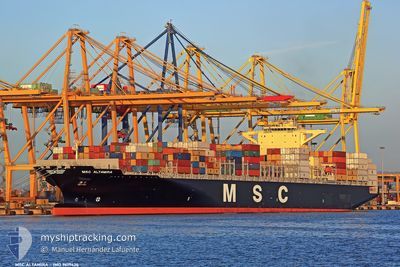
MSC ALTAMIRA
Container Ship
Current Trip
| Time Travelled | 3 days |
|---|---|
| Remaining Time | 53 mins |
| Distance Travelled | 968.12 nm |
| Remaining Distance | 13.02 nm |
| AVG Speed | 11.7 Knots |
| MAX Speed | 14.9 Knots |
| AVG Wind | 14 knots |
| MAX Wind | 27 knots |
| MIN Temp | 23.1°C / 73.58°F |
| MAX Temp | 27.2°C / 80.96°F |
| Draught | 8.8 m |
| Position Received | 1 m ago |
Current Position
| Longitude | -69.66671° |
|---|---|
| Latitude | 18.32354° |
| Status | Under way using engine |
| Speed | 8.2 Knots |
| Course | 58.3° |
| Area | Caribbean Sea |
| Station | T-AIS |
| Position Received | 1 m ago |
Info
Information
The current position of MSC ALTAMIRA is in Caribbean Sea with coordinates 18.32354° / -69.66671° as reported on 2025-02-07 12:02 by AIS to our vessel tracker app. The vessel's current speed is 8.2 Knots and is heading at the port of BOCA CHIKA. The estimated time of arrival as calculated by MyShipTracking vessel tracking app is 2025-02-07 08:57 LT
The vessel MSC ALTAMIRA (IMO: 9619426, MMSI: 636015664) is a Container Ship that was built in 2012 ( 13 years old ). It's sailing under the flag of [LR] Liberia.
In this page you can find informations about the vessels current position, last detected port calls, and current voyage information. If the vessels is not in coverage by AIS you will find the latest position.
The current position of MSC ALTAMIRA is detected by our AIS receivers and we are not responsible for the reliability of the data. The last position was recorded while the vessel was in Coverage by the Ais receivers of our vessel tracking app.
The current draught of MSC ALTAMIRA as reported by AIS is 8.8 meters
Weather
| Temperature | 23.5°C / 74.3°F |
|---|---|
| Wind Speed | 15 knots |
| Direction | 31° NNE |
| Pressure | 1016.9 hPa |
| Humidity | 83 % |
| Cloud Coverage | --- |
Featured Company
Last Port Calls
| Port | Arrival | Departure | Time In Port |
|---|---|---|---|
| 2025-02-03 20:29 | 2025-02-03 20:34 | 5 m | |
| 2025-02-02 18:37 | 2025-02-03 20:14 | 1 d | |
| 2025-02-02 18:12 | 2025-02-02 18:24 | 12 m | |
| 2025-01-31 05:07 | 2025-02-01 01:40 | 20 h | |
| 2025-01-26 16:43 | 2025-01-27 05:14 | 12 h | |
| 2025-01-18 19:48 | 2025-01-19 16:00 | 20 h | |
| 2025-01-16 16:45 | 2025-01-17 09:42 | 16 h | |
| 2025-01-12 15:35 | 2025-01-14 04:59 | 1 d | |
| 2025-01-08 10:19 | 2025-01-09 09:23 | 23 h | |
| 2025-01-03 19:23 | 2025-01-05 12:02 | 1 d |
Most Visited Ports (Last year)
| Port | Arrivals | |
|---|---|---|
| 7 | ||
| 5 | ||
| 4 | ||
| 3 | ||
| 3 | ||
| 3 |
Last Trips
| Origin | Departure | Destination | Arrival | Distance | |
|---|---|---|---|---|---|
| 2025-02-03 20:14 | 2025-02-03 20:29 | 0.47 nm | |||
| 2025-02-02 18:24 | 2025-02-02 18:37 | 0.47 nm | |||
| 2025-02-01 01:40 | 2025-02-02 18:12 | 415.62 nm | |||
| 2025-01-27 05:14 | 2025-01-31 05:07 | 145.10 nm | |||
| 2025-01-19 16:00 | 2025-01-26 16:43 | 781.11 nm | |||
| 2025-01-17 09:42 | 2025-01-18 19:48 | 197.24 nm | |||
| 2025-01-14 04:59 | 2025-01-16 16:45 | 426.38 nm | |||
| 2025-01-09 09:23 | 2025-01-12 15:35 | 950.17 nm | |||
| 2025-01-05 12:02 | 2025-01-08 10:19 | 1245.88 nm | |||
| 2024-12-26 01:42 | 2025-01-03 19:23 | 3619.46 nm |
Events
| Time | Event | Details | Position / Dest | Info |
|---|---|---|---|---|
| 2025-02-07 10:29 | Status Changed | Under way using engine Default |
18.17143 / -69.93586
DOCAU
|
Speed: 11.4 kn Course: 61° |
| 2025-02-07 10:23 | Status Changed | Default Under way using engine |
18.16207 / -69.95332
DOCAU
|
Speed: 11.4 kn Course: 61.5° |
| 2025-02-07 10:17 | Status Changed | Under way using engine Default |
18.15280 / -69.97073
DOCAU
|
Speed: 11.3 kn Course: 60° |
| 2025-02-07 10:14 | Status Changed | Default Under way using engine |
18.14756 / -69.98040
DOCAU
|
Speed: 11.2 kn Course: 60.2° |
| 2025-02-07 10:05 | Status Changed | Under way using engine Default |
18.13413 / -70.00496
DOCAU
|
Speed: 11.1 kn Course: 62° |
| 2025-02-07 10:02 | Status Changed | Default Under way using engine |
18.12857 / -70.01547
DOCAU
|
Speed: 11.1 kn Course: 61.8° |
| 2025-02-07 09:58 | Status Changed | Under way using engine Default |
18.12265 / -70.02680
DOCAU
|
Speed: 11 kn Course: 60° |
| 2025-02-07 09:42 | Status Changed | Default Under way using engine |
18.09896 / -70.07212
DOCAU
|
Speed: 11 kn Course: 61.2° |
| 2025-02-07 09:30 | Change Sea Area | Domican Republic part of the Caribbean Sea United States part of the North Atlantic Ocean |
18.08154 / -70.10476
Caribbean Sea
DOCAU
|
Speed: 11 kn Course: 61.2° |
| 2025-02-07 09:30 | Status Changed | Under way using engine Default |
18.08154 / -70.10476
DOCAU
|
Speed: 11 kn Course: 61° |