
NEW LEGACY
Cargo
Current Trip
| Time Travelled | 20 days |
|---|---|
| Remaining Time | --- |
| Distance Travelled | 4576.81 nm |
| Remaining Distance | 129.69 nm |
| AVG Speed | 9.1 Knots |
| MAX Speed | 13.6 Knots |
| AVG Wind | 20.9 knots |
| MAX Wind | 45 knots |
| MIN Temp | -2.5°C / 27.5°F |
| MAX Temp | 18.5°C / 65.3°F |
| Draught | 9.5 m |
| Position Received | 2 d ago |
Current Position
| Longitude | 140.23095° |
|---|---|
| Latitude | 34.88443° |
| Status | Under way using engine |
| Speed | 9 Knots |
| Course | 242.7° |
| Area | North Pacific Ocean |
| Station | T-AIS |
| Position Received | 2 d ago |
Info
Information
The current position of NEW LEGACY is in North Pacific Ocean with coordinates 34.88443° / 140.23095° as reported on 2025-12-15 20:06 by AIS to our vessel tracker app. The vessel's current speed is 9 Knots and is heading at the port of TOKUYAMA. The estimated time of arrival as calculated by MyShipTracking vessel tracking app is 2025-12-14 12:00 LT
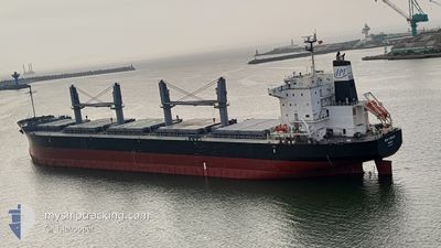
The vessel NEW LEGACY (IMO: 9804942, MMSI: 636018067) is a Cargo It's sailing under the flag of [LR] Liberia.
In this page you can find informations about the vessels current position, last detected port calls, and current voyage information. If the vessels is not in coverage by AIS you will find the latest position.
The current position of NEW LEGACY is detected by our AIS receivers and we are not responsible for the reliability of the data. The last position was recorded while the vessel was in Coverage by the Ais receivers of our vessel tracking app.
The current draught of NEW LEGACY as reported by AIS is 9.5 meters
Weather
| Temperature | 14.3°C / 57.74°F |
|---|---|
| Wind Speed | 11 knots |
| Direction | 353° N |
| Pressure | 1023.7 hPa |
| Humidity | 59.3 % |
| Cloud Coverage | --- |
Featured Company
Last Port Calls
| Port | Arrival | Departure | Time In Port |
|---|---|---|---|
| 2025-11-23 01:33 | 2025-11-26 23:22 | 3 d | |
| 2025-11-23 00:50 | 2025-11-23 01:11 | 21 m | |
| 2025-10-31 07:30 | 2025-11-07 09:59 | 7 d | |
| 2025-10-24 07:56 | 2025-10-29 15:20 | 5 d | |
| 2025-10-18 07:32 | 2025-10-23 16:16 | 5 d | |
| 2025-10-15 06:44 | 2025-10-16 14:12 | 1 d |
Most Visited Ports (Last year)
| Port | Arrivals | |
|---|---|---|
| 12 | ||
| 4 | ||
| 4 | ||
| 3 | ||
| 2 | ||
| 2 |
Last Trips
| Origin | Departure | Destination | Arrival | Distance | |
|---|---|---|---|---|---|
| 2025-11-23 01:11 | 2025-11-23 01:33 | 0.73 nm | |||
| 2025-11-07 09:59 | 2025-11-23 00:50 | 4340.98 nm | |||
| 2025-10-29 15:20 | 2025-10-31 07:30 | 259.78 nm | |||
| 2025-10-23 16:16 | 2025-10-24 07:56 | 17.64 nm | |||
| 2025-10-16 14:12 | 2025-10-18 07:32 | 436.86 nm | |||
| 2025-09-24 20:36 | 2025-10-15 06:44 | 4452.02 nm |
Events
| Time | Event | Details | Position / Dest | Info |
|---|---|---|---|---|
| 2025-12-15 20:14 | Status Changed | Default Under way using engine |
34.87496 / 140.20827
JP TKY
|
Speed: 9 kn Course: 242.7° |
| 2025-12-15 20:06 | OUT of Coverage |
34.88443 / 140.23095
North Pacific Ocean
|
Speed: 9 kn Course: 242.7° |
|
| 2025-12-15 20:05 | Status Changed | Under way using engine Default |
34.88540 / 140.23324
JP TKY
|
Speed: 8.9 kn Course: 244° |
| 2025-12-15 19:46 | Status Changed | Default Under way using engine |
34.90772 / 140.28264
JP TKY
|
Speed: 8.9 kn Course: 234.3° |
| 2025-12-15 19:36 | Status Changed | Under way using engine Default |
34.92182 / 140.30608
JP TKY
|
Speed: 9 kn Course: 230° |
| 2025-12-15 19:26 | Status Changed | Default Under way using engine |
34.93990 / 140.32944
JP TKY
|
Speed: 9.7 kn Course: 230.2° |
| 2025-12-15 19:13 | Change Sea Area | Japanese part of the North Pacific Ocean United States (Alaska) part of the North Pacific Ocean |
34.96294 / 140.36183
North Pacific Ocean
|
Speed: 9.8 kn Course: 229.2° |
| 2025-12-15 19:13 | Status Changed | Under way using engine Default |
34.96294 / 140.36183
JP TKY
|
Speed: 9.8 kn Course: 229° |
| 2025-12-15 18:57 | IN Coverage |
34.96294 / 140.36183
North Pacific Ocean
|
Speed: 9.8 kn Course: 229.2° |