
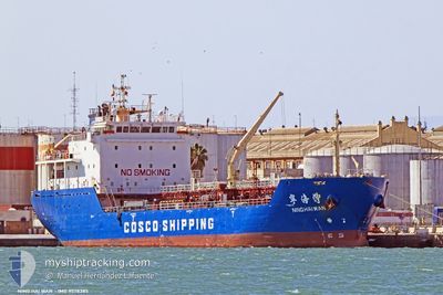
NING HAI WAN
Asphalt/Bitumen Tanker
Current Trip
| Time Travelled | 8 days |
|---|---|
| Remaining Time | --- |
| Distance Travelled | 2254.13 nm |
| Remaining Distance | --- |
| AVG Speed | 11 Knots |
| MAX Speed | 13.2 Knots |
| AVG Wind | 19.6 knots |
| MAX Wind | 33.8 knots |
| MIN Temp | -2.3°C / 27.86°F |
| MAX Temp | 29.9°C / 85.82°F |
| Draught | 6.6 m |
| Position Received | 23 d ago |
Current Position
| Longitude | 103.99517° |
|---|---|
| Latitude | 1.23725° |
| Status | Under way using engine |
| Speed | 10.5 Knots |
| Course | 80.2° |
| Area | Singapore Strait |
| Station | T-AIS |
| Position Received | 23 d ago |
Info
Information
The current position of NING HAI WAN is in Singapore Strait with coordinates 1.23725° / 103.99517° as reported on 2025-01-19 23:34 by AIS to our vessel tracker app. The vessel's current speed is 10.5 Knots and is heading at the port of TERNEUZEN.
The vessel NING HAI WAN (IMO: 9578385, MMSI: 371078000) is a Asphalt/Bitumen Tanker that was built in 2010 ( 15 years old ). It's sailing under the flag of [PA] Panama.
In this page you can find informations about the vessels current position, last detected port calls, and current voyage information. If the vessels is not in coverage by AIS you will find the latest position.
The current position of NING HAI WAN is detected by our AIS receivers and we are not responsible for the reliability of the data. The last position was recorded while the vessel was in Coverage by the Ais receivers of our vessel tracking app.
The current draught of NING HAI WAN as reported by AIS is 6.6 meters
Weather
| Temperature | 30°C / 86°F |
|---|---|
| Wind Speed | 12 knots |
| Direction | 58° ENE |
| Pressure | 1009.1 hPa |
| Humidity | 68 % |
| Cloud Coverage | 6 % |
Featured Company
Last Port Calls
| Port | Arrival | Departure | Time In Port |
|---|---|---|---|
| 2025-02-02 23:42 | 2025-02-03 14:45 | 15 h | |
| 2025-01-30 08:01 | 2025-01-31 23:21 | 1 d | |
| 2025-01-18 06:43 | 2025-01-19 10:29 | 1 d | |
| 2025-01-13 20:08 | 2025-01-15 01:36 | 1 d | |
| 2024-12-10 07:19 | 2024-12-11 13:48 | 1 d | |
| 2024-12-02 03:43 | 2024-12-03 03:57 | 1 d |
Most Visited Ports (Last year)
| Port | Arrivals | |
|---|---|---|
| 17 | ||
| 8 | ||
| 6 | ||
| 5 | ||
| 5 | ||
| 4 |
Last Trips
| Origin | Departure | Destination | Arrival | Distance | |
|---|---|---|---|---|---|
| 2025-02-01 07:21 | 2025-02-03 08:42 | 479.49 nm | |||
| 2025-01-19 18:29 | 2025-01-30 16:01 | 2516.53 nm | |||
| 2025-01-15 08:36 | 2025-01-18 14:43 | 838.48 nm | |||
| 2024-12-11 21:48 | 2025-01-14 03:08 | 1925.70 nm | |||
| 2024-12-03 10:57 | 2024-12-10 15:19 | 1378.13 nm | |||
| 2024-11-29 07:08 | 2024-12-02 10:43 | 137.28 nm |
Events
| Time | Event | Details | Position / Dest | Info |
|---|---|---|---|---|
| 2025-02-03 18:49 | START Moving | 6.1 nm, East of YEOSU |
34.77089 / 127.77982
FOR ORDER
|
Speed: 5.8 kn Course: 142° |
| 2025-02-03 15:24 | STOP Moving | 6.22 nm, North East of YEOSU |
34.77610 / 127.77982
FOR ORDER
|
Speed: Course: 201° |
| 2025-02-03 14:45 | PORT DEPARTURE |
|
34.85427 / 127.78511
FOR ORDER
|
Speed: 10.6 kn Course: 100° |
| 2025-02-03 14:15 | START Moving |
34.86639 / 127.69441
[KR] GWANGYANG
|
Speed: 6.5 kn Course: 77° |
|
| 2025-02-02 23:42 | STOP Moving |
34.86131 / 127.69152
[KR] GWANGYANG
|
Speed: Course: 212° |
|
| 2025-02-02 23:42 | PORT ARRIVAL |
|
34.86131 / 127.69152
[KR] GWANGYANG
|
Speed: 0.6 kn Course: 203° |
| 2025-02-02 22:13 | START Moving | 7.4 nm, East of YEOSU |
34.73066 / 127.81401
FOR ORDER
|
Speed: 7.1 kn Course: 46° |
| 2025-02-02 15:47 | STOP Moving | 7.24 nm, East of YEOSU |
34.73081 / 127.81078
FOR ORDER
|
Speed: 0.3 kn Course: 322° |