
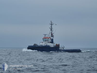
OCEAN CHALLENGER
Tug
Current Trip
BTY SPM
| Time Travelled | 8 h, 32 mins |
|---|---|
| Remaining Time | --- |
| Distance Travelled | 25.97 nm |
| Remaining Distance | --- |
| AVG Speed | 6.5 Knots |
| MAX Speed | 10.6 Knots |
| AVG Wind | 2.6 knots |
| MAX Wind | 5 knots |
| MIN Temp | 3.7°C / 38.66°F |
| MAX Temp | 8.5°C / 47.3°F |
| Draught | 4.8 m |
| Position Received | 1 m ago |
Current Position
| Longitude | -9.52876° |
|---|---|
| Latitude | 51.70074° |
| Status | Restricted manoeuverability |
| Speed | |
| Course | 231° |
| Area | North Atlantic Ocean |
| Station | T-AIS |
| Position Received | 1 m ago |
Info
Information
The current position of OCEAN CHALLENGER is in North Atlantic Ocean with coordinates 51.70074° / -9.52876° as reported on 2025-02-05 16:03 by AIS to our vessel tracker app. The vessel's current speed is 0 Knots
The vessel OCEAN CHALLENGER (IMO: 9085209, MMSI: 250004312) is a Tug that was built in 1994 ( 31 years old ). It's sailing under the flag of [IE] Ireland.
In this page you can find informations about the vessels current position, last detected port calls, and current voyage information. If the vessels is not in coverage by AIS you will find the latest position.
The current position of OCEAN CHALLENGER is detected by our AIS receivers and we are not responsible for the reliability of the data. The last position was recorded while the vessel was in Coverage by the Ais receivers of our vessel tracking app.
The current draught of OCEAN CHALLENGER as reported by AIS is 4.8 meters
Weather
| Temperature | 8.4°C / 47.12°F |
|---|---|
| Wind Speed | 4 knots |
| Direction | 228° SW |
| Pressure | 1039.1 hPa |
| Humidity | 61 % |
| Cloud Coverage | 8 % |
Featured Company
Last Port Calls
| Port | Arrival | Departure | Time In Port |
|---|---|---|---|
| 2025-02-05 07:32 | |||
| 2025-01-20 04:42 | 2025-01-31 08:12 | 11 d | |
| 2025-01-15 14:58 | 2025-01-18 10:49 | 2 d | |
| 2024-12-28 07:31 | 2025-01-15 08:41 | 18 d | |
| 2024-12-27 08:23 | |||
| 2024-12-10 13:45 | 2024-12-10 14:36 | 50 m | |
| 2024-12-09 18:11 |
Most Visited Ports (Last year)
| Port | Arrivals | |
|---|---|---|
| 26 | ||
| 16 | ||
| 7 | ||
| 1 |
Last Trips
| Origin | Departure | Destination | Arrival | Distance | |
|---|---|---|---|---|---|
| 2025-01-18 10:49 | 2025-01-20 04:42 | 35.03 nm | |||
| 2025-01-15 08:41 | 2025-01-15 14:58 | 32.67 nm | |||
| 2024-12-27 08:23 | 2024-12-28 07:31 | 32.42 nm | |||
| 2024-12-09 18:11 | 2024-12-10 13:45 | 140.89 nm |
Events
| Time | Event | Details | Position / Dest | Info |
|---|---|---|---|---|
| 2025-02-05 13:02 | Status Changed | Restricted manoeuverability Under way using engine |
51.69340 / -9.53022
BTY SPM
|
Speed: 0.9 kn Course: 317° |
| 2025-02-05 12:53 | Status Changed | Under way using engine Default |
51.69460 / -9.52959
BTY SPM
|
Speed: 1.5 kn Course: 305° |
| 2025-02-05 12:51 | Status Changed | Default Under way using engine |
51.69546 / -9.52964
BTY SPM
|
Speed: 1.1 kn Course: 284° |
| 2025-02-05 12:10 | STOP Moving | 2.78 nm, North West of BANTRY |
51.70552 / -9.52345
BTY SPM
|
Speed: 0.3 kn Course: 206° |
| 2025-02-05 11:00 | START Moving | 6.19 nm, East of BERE ISLAND |
51.65747 / -9.66013
BTY SPM
|
Speed: 3.4 kn Course: 93° |
| 2025-02-05 10:53 | STOP Moving | 5.93 nm, East of BERE ISLAND |
51.65505 / -9.66661
BTY SPM
|
Speed: 0.2 kn Course: 57° |
| 2025-02-05 10:18 | START Moving | 3.32 nm, West of BANTRY |
51.69434 / -9.54656
BTY SPM
|
Speed: 10.5 kn Course: 241.6° |
| 2025-02-05 09:13 | STOP Moving | 2.97 nm, West of BANTRY |
51.69694 / -9.53577
BTY SPM
|
Speed: 0.3 kn Course: 215° |
| 2025-02-05 08:01 | ETA Changed | 2025/02/05 09:00 2025/01/31 10:00 |
51.65064 / -9.78742
BTY SPM
|
Speed: 9.9 kn Course: 91° |
| 2025-02-05 07:45 | IN Coverage |
51.64882 / -9.85029
North Atlantic Ocean
|
Speed: 9.9 kn Course: 81.1° |