
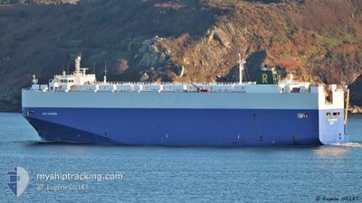
RCC PASSION
Vehicles Carrier
Current Trip
| Trip Time | 9 h, 14 mins |
|---|---|
| Trip Distance | 85.38 nm |
| AVG Speed | 7.4 Knots |
| MAX Speed | 7.4 Knots |
| Draught | 7.8 m |
| AVG Wind | 2.7 knots |
| MAX Wind | 5 knots |
| MIN Temp | 10.2°C / 50.36°F |
| MAX Temp | 14.6°C / 58.28°F |
| Position Received | 1 m ago |
Current Position
| Longitude | -5.50201° |
|---|---|
| Latitude | 35.89102° |
| Status | Moored |
| Speed | |
| Course | 40° |
| Area | Strait of Gibraltar |
| Station | T-AIS |
| Position Received | 1 m ago |
Info
Information
The current position of RCC PASSION is in Strait of Gibraltar with coordinates 35.89102° / -5.50201° as reported on 2025-02-01 06:51 by AIS to our vessel tracker app. The vessel's current speed is 0 Knots and is currently inside the port of TANGER MED.
The vessel RCC PASSION (IMO: 9453107, MMSI: 311048200) is a Vehicles Carrier that was built in 2011 ( 14 years old ). It's sailing under the flag of [BS] Bahamas.
In this page you can find informations about the vessels current position, last detected port calls, and current voyage information. If the vessels is not in coverage by AIS you will find the latest position.
The current position of RCC PASSION is detected by our AIS receivers and we are not responsible for the reliability of the data. The last position was recorded while the vessel was in Coverage by the Ais receivers of our vessel tracking app.
The current draught of RCC PASSION as reported by AIS is 7.8 meters
Weather
| Temperature | 9.4°C / 48.92°F |
|---|---|
| Wind Speed | 7 knots |
| Direction | 261° W |
| Pressure | 1026.6 hPa |
| Humidity | 75.2 % |
| Cloud Coverage | 10 % |
Featured Company
Last Port Calls
| Port | Arrival | Departure | Time In Port |
|---|---|---|---|
| 2025-01-31 22:42 | |||
| 2025-01-31 05:22 | 2025-01-31 13:28 | 8 h | |
| 2025-01-29 11:40 | 2025-01-29 19:36 | 7 h | |
| 2025-01-28 08:29 | 2025-01-29 07:08 | 22 h | |
| 2025-01-26 21:10 | 2025-01-27 12:10 | 14 h | |
| 2025-01-26 13:19 | 2025-01-26 18:52 | 5 h | |
| 2025-01-23 18:31 | 2025-01-23 22:16 | 3 h | |
| 2025-01-19 22:17 | 2025-01-20 23:23 | 1 d | |
| 2025-01-18 18:05 | 2025-01-19 15:00 | 20 h | |
| 2025-01-18 01:50 | 2025-01-18 17:54 | 16 h |
Last Trips
| Origin | Departure | Destination | Arrival | Distance | |
|---|---|---|---|---|---|
| 2025-01-31 14:28 | 2025-01-31 23:42 | 85.38 nm | |||
| 2025-01-29 20:36 | 2025-01-31 06:22 | 443.09 nm | |||
| 2025-01-29 08:08 | 2025-01-29 12:40 | 52.78 nm | |||
| 2025-01-27 13:10 | 2025-01-28 09:29 | 213.36 nm | |||
| 2025-01-26 19:52 | 2025-01-26 22:10 | 30.60 nm | |||
| 2025-01-23 23:16 | 2025-01-26 14:19 | 777.68 nm | |||
| 2025-01-21 02:23 | 2025-01-23 19:31 | 853.94 nm | |||
| 2025-01-19 18:00 | 2025-01-20 01:17 | 75.73 nm | |||
| 2025-01-18 20:54 | 2025-01-18 21:05 | 0.82 nm | |||
| 2025-01-13 15:00 | 2025-01-18 04:50 | 914.81 nm |
Events
| Time | Event | Details | Position / Dest | Info |
|---|---|---|---|---|
| 2025-02-01 02:57 | Status Changed | Moored Default |
35.89104 / -5.50197
[MA] TANGER MED
|
Speed: Course: 40° |
| 2025-02-01 02:51 | Status Changed | Default Moored |
35.89104 / -5.50200
[MA] TANGER MED
|
Speed: Course: 40° |
| 2025-02-01 00:05 | ETA Changed | 2026/01/31 19:40 2025/01/31 19:40 |
35.89104 / -5.50202
[MA] TANGER MED
|
Speed: 0.1 kn Course: 40° |
| 2025-01-31 23:06 | Status Changed | Moored Under way using engine |
35.89117 / -5.50192
[MA] TANGER MED
|
Speed: Course: 39° |
| 2025-01-31 22:48 | STOP Moving |
35.89527 / -5.49702
[MA] TANGER MED
|
Speed: 0.3 kn Course: 313° |
|
| 2025-01-31 22:42 | PORT ARRIVAL |
|
35.90004 / -5.49261
[MA] TANGER MED
|
Speed: 6.3 kn Course: 184.4° |
| 2025-01-31 22:14 | START Moving | 2.12 nm, North West of TANGER MED |
35.91310 / -5.53731
MAPTM
|
Speed: 4.2 kn Course: 70° |
| 2025-01-31 22:08 | STOP Moving | 2.07 nm, North West of TANGER MED |
35.91162 / -5.53885
MAPTM
|
Speed: 0.3 kn Course: 72° |
| 2025-01-31 21:40 | START Moving | 2.65 nm, West of TANGER MED |
35.89539 / -5.57072
MAPTM
|
Speed: 3.1 kn Course: 103° |
| 2025-01-31 20:46 | STOP Moving | 2.86 nm, North of KSAR SEGHIR |
35.89053 / -5.58046
MAPTM
|
Speed: 0.2 kn Course: 237° |