
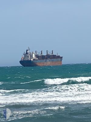
ROMY
Cargo
Current Trip
BRFOR
| Time Travelled | 2 days |
|---|---|
| Remaining Time | --- |
| Distance Travelled | 593.60 nm |
| Remaining Distance | --- |
| AVG Speed | 12 Knots |
| MAX Speed | 15.1 Knots |
| AVG Wind | 12.4 knots |
| MAX Wind | 16 knots |
| MIN Temp | 24.5°C / 76.1°F |
| MAX Temp | 27.6°C / 81.68°F |
| Draught | 9.7 m |
| Position Received | 2 d ago |
Current Position
| Longitude | -38.60988° |
|---|---|
| Latitude | -3.34110° |
| Status | Under way using engine |
| Speed | 13.3 Knots |
| Course | 339.7° |
| Area | South Atlantic Ocean |
| Station | T-AIS |
| Position Received | 2 d ago |
Info
Information
The current position of ROMY is in South Atlantic Ocean with coordinates -3.34110° / -38.60988° as reported on 2025-02-13 12:57 by AIS to our vessel tracker app. The vessel's current speed is 13.3 Knots
The vessel ROMY (IMO: 9890862, MMSI: 538009071) is a Cargo It's sailing under the flag of [MH] Marshall Is.
In this page you can find informations about the vessels current position, last detected port calls, and current voyage information. If the vessels is not in coverage by AIS you will find the latest position.
The current position of ROMY is detected by our AIS receivers and we are not responsible for the reliability of the data. The last position was recorded while the vessel was in Coverage by the Ais receivers of our vessel tracking app.
The current draught of ROMY as reported by AIS is 9.7 meters
Weather
| Temperature | 26.7°C / 80.06°F |
|---|---|
| Wind Speed | 12 knots |
| Direction | 64° ENE |
| Pressure | 1010.8 hPa |
| Humidity | 80.1 % |
| Cloud Coverage | 100 % |
Featured Company
Last Port Calls
| Port | Arrival | Departure | Time In Port |
|---|---|---|---|
| 2025-02-10 08:29 | 2025-02-13 11:11 | 3 d | |
| 2025-01-29 17:28 | 2025-01-31 20:07 | 2 d | |
| 2025-01-16 20:40 | 2025-01-16 21:35 | 54 m | |
| 2024-12-19 04:18 | 2024-12-29 17:50 | 10 d | |
| 2024-12-13 16:14 | 2024-12-14 12:48 | 20 h | |
| 2024-12-11 06:38 | 2024-12-13 14:56 | 2 d |
Most Visited Ports (Last year)
| Port | Arrivals | |
|---|---|---|
| 3 | ||
| 2 | ||
| 2 | ||
| 2 | ||
| 2 | ||
| 1 |
Last Trips
| Origin | Departure | Destination | Arrival | Distance | |
|---|---|---|---|---|---|
| 2025-01-31 17:07 | 2025-02-10 05:29 | 2641.88 nm | |||
| 2025-01-16 18:35 | 2025-01-29 14:28 | 1110.48 nm | |||
| 2024-12-29 18:50 | 2025-01-16 17:40 | 5016.23 nm | |||
| 2024-12-14 13:48 | 2024-12-19 05:18 | 874.43 nm | |||
| 2024-12-13 15:56 | 2024-12-13 17:14 | 5.70 nm | |||
| 2024-11-25 15:52 | 2024-12-11 07:38 | 4137.28 nm |
Events
| Time | Event | Details | Position / Dest | Info |
|---|---|---|---|---|
| 2025-02-13 13:06 | Status Changed | Default Under way using engine |
-3.31044 / -38.62156
BRFOR
|
Speed: 13.3 kn Course: 339.7° |
| 2025-02-13 12:57 | OUT of Coverage |
-3.34110 / -38.60988
South Atlantic Ocean
|
Speed: 13.3 kn Course: 339.7° |
|
| 2025-02-13 11:11 | PORT DEPARTURE |
|
-3.69738 / -38.48838
BRFOR
|
Speed: 6.8 kn Course: 346° |
| 2025-02-13 11:01 | START Moving |
-3.71005 / -38.47746
[BR] FORTALEZA
|
Speed: 3.1 kn Course: 298° |
|
| 2025-02-13 10:35 | Status Changed | Under way using engine Default |
-3.71078 / -38.47481
[BR] FORTALEZA
|
Speed: Course: 201° |
| 2025-02-13 10:29 | Status Changed | Default Moored |
-3.71078 / -38.47480
[BR] FORTALEZA
|
Speed: 0.1 kn Course: 201° |
| 2025-02-13 10:23 | Status Changed | Moored Default |
-3.71078 / -38.47480
[BR] FORTALEZA
|
Speed: Course: 201° |
| 2025-02-13 10:17 | Status Changed | Default Moored |
-3.71078 / -38.47480
[BR] FORTALEZA
|
Speed: Course: 201° |
| 2025-02-13 09:41 | Status Changed | Moored Default |
-3.71077 / -38.47480
[BR] FORTALEZA
|
Speed: Course: 201° |
| 2025-02-13 09:29 | Status Changed | Default Moored |
-3.71079 / -38.47481
[BR] FORTALEZA
|
Speed: Course: 201° |