
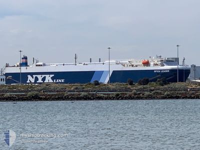
SPICA LEADER
Vehicles Carrier
Current Trip
| Time Travelled | 7 days |
|---|---|
| Remaining Time | --- |
| Distance Travelled | 2539.39 nm |
| Remaining Distance | --- |
| AVG Speed | 15.2 Knots |
| MAX Speed | 18 Knots |
| AVG Wind | 7.5 knots |
| MAX Wind | 20 knots |
| MIN Temp | 17.8°C / 64.04°F |
| MAX Temp | 28.2°C / 82.76°F |
| Draught | 7.7 m |
| Position Received | 21 h, 51 m ago |
Current Position
| Longitude | 80.22863° |
|---|---|
| Latitude | 5.61097° |
| Status | Under way using engine |
| Speed | 14.6 Knots |
| Course | 95.4° |
| Area | Laccadive Sea |
| Station | T-AIS |
| Position Received | 21 h, 51 m ago |
Info
Information
The current position of SPICA LEADER is in Laccadive Sea with coordinates 5.61097° / 80.22863° as reported on 2025-02-23 07:21 by AIS to our vessel tracker app. The vessel's current speed is 14.6 Knots and is heading at the port of NANSHA. The estimated time of arrival as calculated by MyShipTracking vessel tracking app is 2025-03-03 19:00 LT
The vessel SPICA LEADER (IMO: 9536909, MMSI: 636020245) is a Vehicles Carrier that was built in 2012 ( 13 years old ). It's sailing under the flag of [LR] Liberia.
In this page you can find informations about the vessels current position, last detected port calls, and current voyage information. If the vessels is not in coverage by AIS you will find the latest position.
The current position of SPICA LEADER is detected by our AIS receivers and we are not responsible for the reliability of the data. The last position was recorded while the vessel was in Coverage by the Ais receivers of our vessel tracking app.
The current draught of SPICA LEADER as reported by AIS is 7.7 meters
Weather
| Temperature | 27.9°C / 82.22°F |
|---|---|
| Wind Speed | 15 knots |
| Direction | 40° NE |
| Pressure | 1013.5 hPa |
| Humidity | 75.5 % |
| Cloud Coverage | 16 % |
Featured Company
Last Port Calls
| Port | Arrival | Departure | Time In Port |
|---|---|---|---|
| 2025-02-13 21:22 | 2025-02-17 05:02 | 3 d | |
| 2025-02-03 22:36 | 2025-02-04 10:56 | 12 h | |
| 2025-02-02 06:42 | 2025-02-03 09:32 | 1 d | |
| 2025-01-30 06:33 | 2025-01-31 06:24 | 23 h | |
| 2025-01-24 22:05 | 2025-01-25 10:29 | 12 h | |
| 2025-01-02 03:12 | 2025-01-02 17:09 | 13 h | |
| 2024-12-30 23:14 | 2024-12-31 08:01 | 8 h | |
| 2024-12-27 12:47 | 2024-12-27 20:06 | 7 h | |
| 2024-12-15 12:22 | 2024-12-15 19:19 | 6 h | |
| 2024-12-13 02:33 | 2024-12-13 08:56 | 6 h |
Most Visited Ports (Last year)
| Port | Arrivals | |
|---|---|---|
| 9 | ||
| 4 | ||
| 4 | ||
| 3 | ||
| 2 | ||
| 2 |
Last Trips
| Origin | Departure | Destination | Arrival | Distance | |
|---|---|---|---|---|---|
| 2025-02-04 18:56 | 2025-02-14 00:22 | 3769.61 nm | |||
| 2025-02-03 17:32 | 2025-02-04 06:36 | 13.75 nm | |||
| 2025-01-31 13:24 | 2025-02-02 14:42 | 823.68 nm | |||
| 2025-01-25 18:29 | 2025-01-30 13:33 | 1876.53 nm | |||
| 2025-01-02 12:09 | 2025-01-25 06:05 | 9360.81 nm | |||
| 2024-12-31 03:01 | 2025-01-01 22:12 | 602.08 nm | |||
| 2024-12-27 15:06 | 2024-12-30 18:14 | 445.58 nm | |||
| 2024-12-15 13:19 | 2024-12-27 07:47 | 926.35 nm | |||
| 2024-12-13 02:56 | 2024-12-15 06:22 | 229.96 nm | |||
| 2024-12-09 10:10 | 2024-12-12 20:33 | 62.29 nm |
Events
| Time | Event | Details | Position / Dest | Info |
|---|---|---|---|---|
| 2025-02-23 07:23 | Status Changed | Default Under way using engine |
5.61001 / 80.24004
SADMM>CNNSA
|
Speed: 14.6 kn Course: 95.4° |
| 2025-02-23 07:21 | OUT of Coverage |
5.61097 / 80.22863
Laccadive Sea
SADMM>CNNSA
|
Speed: 14.6 kn Course: 95.4° |
|
| 2025-02-23 05:09 | Change Sea Area | Sri Lankan part of the Laccadive Sea Indian part of the Laccadive Sea |
5.76769 / 79.69896
Laccadive Sea
SADMM>CNNSA
|
Speed: 15.2 kn Course: 108.7° |
| 2025-02-23 05:09 | Status Changed | Under way using engine Default |
5.76769 / 79.69896
SADMM>CNNSA
|
Speed: 15.1 kn Course: 109° |
| 2025-02-23 05:09 | IN Coverage |
5.76769 / 79.69896
Laccadive Sea
SADMM>CNNSA
|
Speed: 15.2 kn Course: 108.7° |
|
| 2025-02-22 20:33 | Status Changed | Default Under way using engine |
6.91351 / 77.82153
SADMM>CNNSA
|
Speed: 15.9 kn Course: 116° |
| 2025-02-22 20:31 | OUT of Coverage |
6.91672 / 77.81505
Laccadive Sea
SADMM>CNNSA
|
Speed: 15.9 kn Course: 116° |
|
| 2025-02-22 20:30 | Status Changed | Under way using engine Default |
6.92007 / 77.80830
SADMM>CNNSA
|
Speed: 15.7 kn Course: 116° |
| 2025-02-22 19:45 | Status Changed | Default Under way using engine |
7.00917 / 77.63487
SADMM>CNNSA
|
Speed: 16 kn Course: 117.2° |
| 2025-02-22 19:19 | Status Changed | Under way using engine Default |
7.06368 / 77.52646
SADMM>CNNSA
|
Speed: 15.8 kn Course: 117° |