
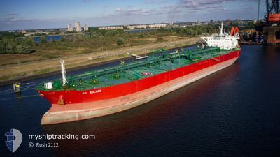
STI SOLACE
Tanker
Current Trip
| Time Travelled | 6 days |
|---|---|
| Remaining Time | 8 days |
| Distance Travelled | 1724.79 nm |
| Remaining Distance | 2307.27 nm |
| AVG Speed | 11.5 Knots |
| MAX Speed | 14.6 Knots |
| AVG Wind | 10.9 knots |
| MAX Wind | 22 knots |
| MIN Temp | 23.2°C / 73.76°F |
| MAX Temp | 28.7°C / 83.66°F |
| Draught | 13.7 m |
| Position Received | 3 d ago |
Current Position
| Longitude | 105.27605° |
|---|---|
| Latitude | -6.33351° |
| Status | Under way using engine |
| Speed | 10.6 Knots |
| Course | 244.4° |
| Area | Java Sea |
| Station | T-AIS |
| Position Received | 3 d ago |
Info
Information
The current position of STI SOLACE is in Java Sea with coordinates -6.33351° / 105.27605° as reported on 2025-12-14 13:39 by AIS to our vessel tracker app. The vessel's current speed is 10.6 Knots and is heading at the port of MELBOURNE. The estimated time of arrival as calculated by MyShipTracking vessel tracking app is 2025-12-27 12:34 LT
The vessel STI SOLACE (IMO: 9708588, MMSI: 538006077) is a Tanker It's sailing under the flag of [MH] Marshall Is.
In this page you can find informations about the vessels current position, last detected port calls, and current voyage information. If the vessels is not in coverage by AIS you will find the latest position.
The current position of STI SOLACE is detected by our AIS receivers and we are not responsible for the reliability of the data. The last position was recorded while the vessel was in Coverage by the Ais receivers of our vessel tracking app.
The current draught of STI SOLACE as reported by AIS is 13.7 meters
Weather
| Temperature | 23.3°C / 73.94°F |
|---|---|
| Wind Speed | 21 knots |
| Direction | 155° SSE |
| Pressure | 1011.7 hPa |
| Humidity | 80.7 % |
| Cloud Coverage | 21 % |
Featured Company
Last Port Calls
| Port | Arrival | Departure | Time In Port |
|---|---|---|---|
| 2025-12-10 18:22 | 2025-12-12 09:29 | 1 d | |
| 2025-12-08 20:59 | 2025-12-10 17:20 | 1 d | |
| 2025-10-31 11:20 | 2025-11-01 11:20 | 23 h |
Most Visited Ports (Last year)
| Port | Arrivals | |
|---|---|---|
| 2 | ||
| 2 | ||
| 1 | ||
| 1 | ||
| 1 | ||
| 1 |
Last Trips
| Origin | Departure | Destination | Arrival | Distance | |
|---|---|---|---|---|---|
| 2025-12-10 17:20 | 2025-12-10 18:22 | 4.31 nm | |||
| 2025-11-01 11:20 | 2025-12-08 20:59 | 3154.78 nm | |||
| 2025-09-09 19:48 | 2025-10-31 11:20 | 13862.90 nm |
Events
| Time | Event | Details | Position / Dest | Info |
|---|---|---|---|---|
| 2025-12-14 13:40 | Status Changed | Default Under way using engine |
-6.33496 / 105.27299
AUMEL
|
Speed: 10.6 kn Course: 244.4° |
| 2025-12-14 13:39 | Status Changed | Under way using engine Default |
-6.33351 / 105.27605
AUMEL
|
Speed: 10.4 kn Course: 244° |
| 2025-12-14 13:39 | OUT of Coverage |
-6.33351 / 105.27605
Java Sea
AUMEL
|
Speed: 10.6 kn Course: 244.4° |
|
| 2025-12-14 13:31 | Status Changed | Default Under way using engine |
-6.32296 / 105.29720
AUMEL
|
Speed: 10.5 kn Course: 243° |
| 2025-12-14 12:17 | Status Changed | Under way using engine Default |
-6.21782 / 105.49359
AUMEL
|
Speed: 11.2 kn Course: 240° |
| 2025-12-14 11:59 | Status Changed | Default Under way using engine |
-6.19174 / 105.53925
AUMEL
|
Speed: 11.4 kn Course: 219.7° |
| 2025-12-14 11:52 | Status Changed | Under way using engine Default |
-6.17744 / 105.55448
AUMEL
|
Speed: 11.2 kn Course: 220° |
| 2025-12-14 11:40 | Status Changed | Default Under way using engine |
-6.14795 / 105.57938
AUMEL
|
Speed: 11.4 kn Course: 220.5° |
| 2025-12-14 11:39 | Status Changed | Under way using engine Default |
-6.14676 / 105.58034
AUMEL
|
Speed: 11.4 kn Course: 221° |
| 2025-12-14 11:32 | Status Changed | Default Under way using engine |
-6.12929 / 105.59531
AUMEL
|
Speed: 11.2 kn Course: 220.9° |