
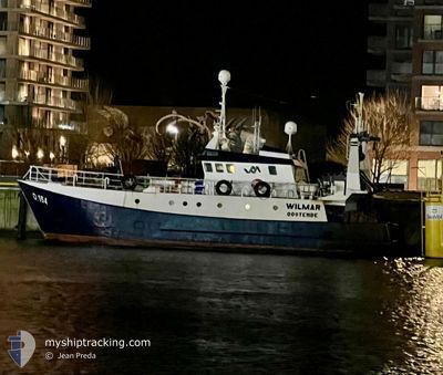
WILMAR
Other Type
Current Trip
| Trip Time | 19 h, 47 mins |
|---|---|
| Trip Distance | 123.61 nm |
| AVG Speed | 6 Knots |
| MAX Speed | 10.6 Knots |
| Draught | 3.6 m |
| AVG Wind | 14.7 knots |
| MAX Wind | 22 knots |
| MIN Temp | 7.2°C / 44.96°F |
| MAX Temp | 10.5°C / 50.9°F |
| Position Received | 18 h, 37 m ago |
Current Position
| Longitude | 2.93566° |
|---|---|
| Latitude | 51.23206° |
| Status | Engaged in Fishing |
| Speed | |
| Course | 318° |
| Area | North Sea |
| Station | T-AIS |
| Position Received | 18 h, 37 m ago |
Info
Information
The current position of WILMAR is in North Sea with coordinates 51.23206° / 2.93566° as reported on 2025-12-18 03:26 by AIS to our vessel tracker app. The vessel's current speed is 0 Knots and is currently inside the port of OOSTENDE.
The vessel WILMAR (MMSI: 205165000) is a Other Type It's sailing under the flag of [BE] Belgium.
In this page you can find informations about the vessels current position, last detected port calls, and current voyage information. If the vessels is not in coverage by AIS you will find the latest position.
The current position of WILMAR is detected by our AIS receivers and we are not responsible for the reliability of the data. The last position was recorded while the vessel was in Coverage by the Ais receivers of our vessel tracking app.
The current draught of WILMAR as reported by AIS is 3.6 meters
Weather
| Temperature | 8.5°C / 47.3°F |
|---|---|
| Wind Speed | 21 knots |
| Direction | 190° S |
| Pressure | 1012.9 hPa |
| Humidity | 69.4 % |
| Cloud Coverage | 100 % |
Featured Company
Last Port Calls
| Port | Arrival | Departure | Time In Port |
|---|---|---|---|
| 2025-12-17 22:04 | |||
| 2025-12-14 22:27 | 2025-12-17 02:17 | 2 d | |
| 2025-12-09 21:51 | 2025-12-10 02:30 | 4 h | |
| 2025-12-05 00:42 | 2025-12-07 02:14 | 2 d | |
| 2025-11-30 23:14 | 2025-12-02 04:43 | 1 d | |
| 2025-11-22 22:50 | 2025-11-29 01:24 | 6 d | |
| 2025-11-16 14:20 | 2025-11-20 10:31 | 3 d | |
| 2025-10-31 08:47 | 2025-11-14 22:29 | 14 d | |
| 2025-10-30 16:13 | 2025-10-31 07:38 | 15 h | |
| 2025-10-22 06:23 | 2025-10-22 17:22 | 10 h |
Most Visited Ports (Last year)
| Port | Arrivals | |
|---|---|---|
| 13 | ||
| 13 | ||
| 5 | ||
| 2 |
Last Trips
| Origin | Departure | Destination | Arrival | Distance | |
|---|---|---|---|---|---|
| 2025-12-17 02:17 | 2025-12-17 22:04 | 123.61 nm | |||
| 2025-12-10 02:30 | 2025-12-14 22:27 | 473.30 nm | |||
| 2025-12-07 02:14 | 2025-12-09 21:51 | 259.65 nm | |||
| 2025-12-02 04:43 | 2025-12-05 00:42 | 267.53 nm | |||
| 2025-11-29 01:24 | 2025-11-30 23:14 | 188.06 nm | |||
| 2025-11-20 10:31 | 2025-11-22 22:50 | 245.46 nm | |||
| 2025-11-14 22:29 | 2025-11-16 14:20 | 175.00 nm | |||
| 2025-10-31 07:38 | 2025-10-31 08:47 | 10.10 nm | |||
| 2025-10-22 17:22 | 2025-10-30 16:13 | 457.58 nm | |||
| 2025-10-14 06:55 | 2025-10-22 06:23 | 223.57 nm |
Events
| Time | Event | Details | Position / Dest | Info |
|---|---|---|---|---|
| 2025-12-18 03:26 | OUT of Coverage |
51.23206 / 2.93566
North Sea
[BE] OOSTENDE
|
Speed: Course: 318° |
|
| 2025-12-17 21:39 | STOP Moving |
51.23208 / 2.93561
[BE] OOSTENDE
|
Speed: 0.3 kn Course: 186° |
|
| 2025-12-17 21:33 | START Moving |
51.23482 / 2.93112
[BE] OOSTENDE
|
Speed: 3.2 kn Course: 143° |
|
| 2025-12-17 21:13 | STOP Moving |
51.23481 / 2.92774
[BE] OOSTENDE
|
Speed: 0.1 kn Course: 78° |
|
| 2025-12-17 21:04 | PORT ARRIVAL |
|
51.24100 / 2.91781
[BE] OOSTENDE
|
Speed: 8.5 kn Course: 148.8° |
| 2025-12-17 19:08 | Change Sea Area | Belgian part of the North Sea French part of the North Sea |
51.18788 / 2.46263
North Sea
FISHING_GROUND _,: .
|
Speed: 8.4 kn Course: 69.8° |
| 2025-12-17 15:56 | START Moving | 14.5 nm, North of CALAIS |
51.20359 / 1.94000
FISHING_GROUND _,: .
|
Speed: 4.2 kn Course: 325° |
| 2025-12-17 15:53 | STOP Moving | 14.46 nm, North of CALAIS |
51.20250 / 1.94235
FISHING_GROUND _,: .
|
Speed: 0.3 kn Course: 275° |
| 2025-12-17 11:34 | Change Sea Area | French part of the North Sea United Kingdom part of the North Sea |
51.14920 / 1.80969
North Sea
FISHING_GROUND _,: .
|
Speed: 4.4 kn Course: 80.5° |
| 2025-12-17 10:18 | Change Sea Area | United Kingdom part of the North Sea French part of the North Sea |
51.08800 / 1.68492
North Sea
FISHING_GROUND _,: .
|
Speed: 5.8 kn Course: 18.7° |