
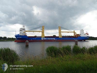
BBC RUBY
Cargo
Current Trip
| Trip Time | 19 h, 43 mins |
|---|---|
| Trip Distance | 171.11 nm |
| AVG Speed | 12.8 Knots |
| MAX Speed | 16.8 Knots |
| Dybgang | 6.9 m |
| AVG Wind | 6.2 knots |
| MAX Wind | 8.5 knots |
| MIN Temp | 20.6°C / 69.08°F |
| MAX Temp | 22.1°C / 71.78°F |
| Position Modtaget | 1 d siden |
Current Position
| Longitude | 54.55136° |
|---|---|
| Latitude | 25.01386° |
| Status | Under way using engine |
| Fart | 16.2 Knots |
| Kurs | 330.8° |
| Område | Persian Gulf |
| Station | T-AIS |
| Position Modtaget | 1 d siden |
Info
Information
The current position of BBC RUBY is in Persian Gulf with coordinates 25.01386° / 54.55136° as reported on 2025-12-24 13:37 by AIS to our vessel tracker app. The vessel's current speed is 16.2 Knots and is currently inside the port of JABAL AZ ZANNAH.
The vessel BBC RUBY (IMO: 9563744, MMSI: 305908000) is a Cargo It's sailing under the flag of [AG] Antigua Barbuda.
In this page you can find informations about the vessels current position, last detected port calls, and current voyage information. If the vessels is not in coverage by AIS you will find the latest position.
The current position of BBC RUBY is detected by our AIS receivers and we are not responsible for the reliability of the data. The last position was recorded while the vessel was in Coverage by the Ais receivers of our vessel tracking app.
The current draught of BBC RUBY as reported by AIS is 6.9 meters
Weather
| Temperature | 21.3°C / 70.34°F |
|---|---|
| Wind Speed | 8 knots |
| Direction | 358° N |
| Pressure | 1016.3 hPa |
| Humidity | 64.3 % |
| Cloud Coverage | 1 % |
Featured Company
Last Port Calls
| Port | Arrival | Departure | Time In Port |
|---|---|---|---|
| 2025-12-25 08:19 | |||
| 2025-12-23 20:06 | 2025-12-24 12:36 | 16 h | |
| 2025-12-20 20:26 | 2025-12-23 13:20 | 2 d | |
| 2025-12-17 10:43 | 2025-12-18 19:05 | 1 d | |
| 2025-12-13 04:21 | 2025-12-14 17:19 | 1 d | |
| 2025-12-10 03:49 | 2025-12-12 03:00 | 1 d | |
| 2025-12-07 18:20 | 2025-12-09 16:03 | 1 d | |
| 2025-11-27 20:11 | 2025-12-01 20:09 | 3 d | |
| 2025-11-16 04:29 | 2025-11-17 20:00 | 1 d | |
| 2025-11-08 12:24 | 2025-11-12 22:39 | 4 d |
Last Trips
| Origin | Departure | Destination | Arrival | Distance | |
|---|---|---|---|---|---|
| 2025-12-24 16:36 | 2025-12-25 12:19 | 171.11 nm | |||
| 2025-12-23 17:20 | 2025-12-24 00:06 | 56.93 nm | |||
| 2025-12-18 23:05 | 2025-12-21 00:26 | 704.59 nm | |||
| 2025-12-14 20:19 | 2025-12-17 14:43 | 956.35 nm | |||
| 2025-12-12 07:00 | 2025-12-13 07:21 | 376.56 nm | |||
| 2025-12-09 20:03 | 2025-12-10 07:49 | 163.80 nm | |||
| 2025-12-02 01:39 | 2025-12-07 22:20 | 1080.82 nm | |||
| 2025-11-18 01:30 | 2025-11-28 01:41 | 41.50 nm | |||
| 2025-11-13 03:39 | 2025-11-16 09:59 | 253.50 nm | |||
| 2025-11-01 07:42 | 2025-11-08 17:24 | 1325.63 nm |
Events
| Tid | Hændelsen | Detaljer | Position / Dest | Info |
|---|---|---|---|---|
| 2025-12-25 08:46 | STOP Sejllads |
24.18385 / 52.56670
[AE] JABAL AZ ZANNAH
|
Fart: Kurs: 323° |
|
| 2025-12-25 08:19 | Skibe i havn |
|
24.18518 / 52.56531
[AE] JABAL AZ ZANNAH
|
Fart: 7 kn Kurs: 108° |
| 2025-12-25 08:01 | START Sejllads | 2.4 nm, West of JABAL AZ ZANNAH |
24.19581 / 52.54114
MUGHARRAQ
|
Fart: 7 kn Kurs: 108° |
| 2025-12-25 01:30 | STOP Sejllads | 3.52 nm, South West of JABAL AZ ZANNAH |
24.18378 / 52.52429
MUGHARRAQ
|
Fart: 0.1 kn Kurs: 355° |
| 2025-12-24 13:38 | Status er ændret | Default Under way using engine |
25.01650 / 54.54974
MUGHARRAQ
|
Fart: 16.2 kn Kurs: 330.8° |
| 2025-12-24 13:37 | Udenfor Dækning |
25.01386 / 54.55136
Persian Gulf
|
Fart: 16.2 kn Kurs: 330.8° |
|
| 2025-12-24 13:30 | Status er ændret | Under way using engine Default |
24.98593 / 54.56970
MUGHARRAQ
|
Fart: 15.8 kn Kurs: 329° |
| 2025-12-24 13:26 | Status er ændret | Default Under way using engine |
24.97004 / 54.58031
MUGHARRAQ
|
Fart: 15.4 kn Kurs: 328.8° |
| 2025-12-24 12:36 | Afsejlet fra sidste havn |
|
24.83383 / 54.67062
MUGHARRAQ
|
Fart: 8.2 kn Kurs: 324° |
| 2025-12-24 12:17 | Destination er ændret | MUGHARRAQ AE KHL |
24.80820 / 54.65795
[AE] KHALIFA
|
Fart: 5 kn Kurs: 50° |