
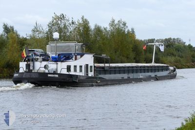
CONTESSA
Cargo
Current Trip
| Time Travelled | 1 day |
|---|---|
| Remaining Time | 1 h, 49 mins |
| Distance Travelled | 82.63 nm |
| Remaining Distance | 12.93 nm |
| AVG Speed | 6.5 Knots |
| MAX Speed | 8.4 Knots |
| AVG Wind | 9 knots |
| MAX Wind | 11 knots |
| MIN Temp | 1.4°C / 34.52°F |
| MAX Temp | 6.9°C / 44.42°F |
| Dybgang | 0.1 m |
| Position Modtaget | Nu |
Current Position
| Longitude | 5.53754° |
|---|---|
| Latitude | 51.96792° |
| Status | Default |
| Fart | 6.3 Knots |
| Kurs | 118.3° |
| Område | North Sea |
| Station | T-AIS |
| Position Modtaget | Nu |
Info
Information
The current position of CONTESSA is in North Sea with coordinates 51.96792° / 5.53754° as reported on 2025-03-14 16:50 by AIS to our vessel tracker app. The vessel's current speed is 6.3 Knots and is heading at the port of ARNHEM. The estimated time of arrival as calculated by MyShipTracking vessel tracking app is 2025-03-14 19:39 LT
The vessel CONTESSA (MMSI: 205370390) is a Cargo It's sailing under the flag of [BE] Belgium.
In this page you can find informations about the vessels current position, last detected port calls, and current voyage information. If the vessels is not in coverage by AIS you will find the latest position.
The current position of CONTESSA is detected by our AIS receivers and we are not responsible for the reliability of the data. The last position was recorded while the vessel was in Coverage by the Ais receivers of our vessel tracking app.
The current draught of CONTESSA as reported by AIS is 0.1 meters
Weather
| Temperature | 5.8°C / 42.44°F |
|---|---|
| Wind Speed | 11 knots |
| Direction | 354° N |
| Pressure | 1011.1 hPa |
| Humidity | 54.1 % |
| Cloud Coverage | 98 % |
Featured Company
Last Port Calls
| Port | Arrival | Departure | Time In Port |
|---|---|---|---|
| 2025-03-12 16:38 | 2025-03-13 16:01 | 23 h | |
| 2025-03-11 22:37 | 2025-03-12 05:59 | 7 h | |
| 2025-03-11 16:14 | 2025-03-11 18:05 | 1 h | |
| 2025-03-10 08:25 | 2025-03-10 09:19 | 53 m | |
| 2025-03-06 22:09 | 2025-03-06 22:20 | 10 m | |
| 2025-03-06 18:54 | 2025-03-06 20:10 | 1 h | |
| 2025-03-06 12:42 | 2025-03-06 17:26 | 4 h | |
| 2025-03-04 22:31 | 2025-03-06 12:23 | 1 d | |
| 2025-03-04 20:40 | 2025-03-04 21:53 | 1 h | |
| 2025-03-04 19:12 | 2025-03-04 19:27 | 14 m |
Last Trips
| Origin | Departure | Destination | Arrival | Distance | |
|---|---|---|---|---|---|
| 2025-03-12 05:59 | 2025-03-12 16:38 | 77.94 nm | |||
| 2025-03-11 18:05 | 2025-03-11 22:37 | 37.64 nm | |||
| 2025-03-10 09:19 | 2025-03-11 16:14 | 18.31 nm | |||
| 2025-03-06 22:20 | 2025-03-10 08:25 | 100.35 nm | |||
| 2025-03-06 20:10 | 2025-03-06 22:09 | 11.07 nm | |||
| 2025-03-06 17:26 | 2025-03-06 18:54 | 10.03 nm | |||
| 2025-03-06 12:23 | 2025-03-06 12:42 | 2.88 nm | |||
| 2025-03-04 21:53 | 2025-03-04 22:31 | 4.74 nm | |||
| 2025-03-04 19:27 | 2025-03-04 20:40 | 10.75 nm | |||
| 2025-03-03 16:47 | 2025-03-04 19:12 | 120.36 nm |
Events
| Tid | Hændelsen | Detaljer | Position / Dest | Info |
|---|---|---|---|---|
| 2025-03-14 16:03 | START Sejllads | 0.47 nm, North of MAURIK |
51.97717 / 5.41235
NVT
|
Fart: 4.9 kn Kurs: 72.4° |
| 2025-03-14 15:28 | STOP Sejllads | 0.49 nm, North West of MAURIK |
51.97529 / 5.40419
NVT
|
Fart: Kurs: 511° |
| 2025-03-14 13:33 | START Sejllads | 1.42 nm, East of VIANEN |
51.99133 / 5.13588
NVT
|
Fart: 5.2 kn Kurs: 144.6° |
| 2025-03-14 13:20 | STOP Sejllads | 1.34 nm, East of VIANEN |
51.99323 / 5.13362
NVT
|
Fart: 0.3 kn Kurs: 511° |
| 2025-03-14 08:18 | Indenfor Dækning |
51.76885 / 4.62726
North Sea
|
Fart: 8.2 kn Kurs: 4° |
|
| 2025-03-14 07:35 | Udenfor Dækning |
51.69434 / 4.53017
North Sea
|
Fart: 6.1 kn Kurs: 77.2° |
|
| 2025-03-14 06:57 | START Sejllads | 0.47 nm, North West of WILLEMSTAD |
51.69923 / 4.43053
NVT
|
Fart: 5.9 kn Kurs: 68° |
| 2025-03-14 06:50 | Indenfor Dækning |
51.69722 / 4.45062
North Sea
|
Fart: 6 kn Kurs: 102.9° |
|
| 2025-03-14 00:38 | Udenfor Dækning |
51.69543 / 4.42174
North Sea
|
Fart: Kurs: 0° |
|
| 2025-03-14 00:38 | Indenfor Dækning |
51.69543 / 4.42174
North Sea
|
Fart: Kurs: 0° |