
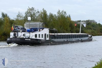
CONTESSA
Cargo
Current Trip
NVT
| Time Travelled | 2 days |
|---|---|
| Remaining Time | --- |
| Distance Travelled | 36.38 nm |
| Remaining Distance | --- |
| AVG Speed | 4.7 Noeuds |
| MAX Speed | 7.9 Noeuds |
| AVG Wind | 12.2 knots |
| MAX Wind | 17.4 knots |
| MIN Temp | 10°C / 50°F |
| MAX Temp | 11.7°C / 53.06°F |
| Tirant d eau | 0.1 m |
| Position reçue | Maintenant |
Current Position
| Longitude | 5.43967° |
|---|---|
| Latitude | 51.64960° |
| Etat | Default |
| Vitesse | |
| Parcours | --- |
| Zone | North Sea |
| Station | T-AIS |
| Position reçue | Maintenant |
Info
Information
The current position of CONTESSA is in North Sea with coordinates 51.64960° / 5.43967° as reported on 2025-02-25 03:33 by AIS to our vessel tracker app. The vessel's current speed is 0 Noeuds
The vessel CONTESSA (MMSI: 205370390) is a Cargo It's sailing under the flag of [BE] Belgium.
In this page you can find informations about the vessels current position, last detected port calls, and current voyage information. If the vessels is not in coverage by AIS you will find the latest position.
The current position of CONTESSA is detected by our AIS receivers and we are not responsible for the reliability of the data. The last position was recorded while the vessel was in Coverage by the Ais receivers of our vessel tracking app.
The current draught of CONTESSA as reported by AIS is 0.1 meters
Weather
| Temperature | 5.9°C / 42.62°F |
|---|---|
| Wind Speed | 7 knots |
| Direction | 195° SSW |
| Pressure | 1014.3 hPa |
| Humidity | 97.3 % |
| Cloud Coverage | 12 % |
Featured Company
Last Port Calls
| Port | Arrival | Departure | Time In Port |
|---|---|---|---|
| 2025-02-22 13:40 | 2025-02-22 14:19 | 39 m | |
| 2025-02-21 08:30 | 2025-02-22 04:59 | 20 h | |
| 2025-02-18 13:31 | 2025-02-20 14:50 | 2 d | |
| 2025-02-17 08:30 | 2025-02-17 09:42 | 1 h | |
| 2025-02-15 20:55 | 2025-02-16 06:23 | 9 h | |
| 2025-02-13 18:28 | 2025-02-15 19:23 | 2 d | |
| 2025-02-13 07:33 | 2025-02-13 16:30 | 8 h | |
| 2025-02-11 14:23 | 2025-02-12 07:27 | 17 h | |
| 2025-02-08 10:44 | 2025-02-11 06:05 | 2 d | |
| 2025-02-08 07:54 | 2025-02-08 09:00 | 1 h |
Last Trips
| Origin | Departure | Destination | Arrival | Distance | |
|---|---|---|---|---|---|
| 2025-02-22 05:59 | 2025-02-22 14:40 | 50.55 nm | |||
| 2025-02-20 15:50 | 2025-02-21 09:30 | 80.85 nm | |||
| 2025-02-17 10:42 | 2025-02-18 14:31 | 17.65 nm | |||
| 2025-02-16 07:23 | 2025-02-17 09:30 | 87.24 nm | |||
| 2025-02-15 20:23 | 2025-02-15 21:55 | 8.53 nm | |||
| 2025-02-13 17:30 | 2025-02-13 19:28 | 12.59 nm | |||
| 2025-02-12 08:27 | 2025-02-13 08:33 | 103.39 nm | |||
| 2025-02-11 07:05 | 2025-02-11 15:23 | 5.74 nm | |||
| 2025-02-08 10:00 | 2025-02-08 11:44 | 10.99 nm | |||
| 2025-02-07 07:28 | 2025-02-08 08:54 | 73.46 nm |
Events
| Heure | Evenement | Détails | Position/ Destination | Info |
|---|---|---|---|---|
| 2025-02-24 17:38 | Arret | 3.43 nm, North West of VEGHEL |
51.64844 / 5.44465
NVT
|
Vitesse: Parcours: 511° |
| 2025-02-24 16:14 | Démarrage | 3.12 nm, South East of VEGHEL |
51.58107 / 5.58211
NVT
|
Vitesse: 5.6 kn Parcours: 323.1° |
| 2025-02-24 16:02 | Arret | 3.44 nm, South East of VEGHEL |
51.57674 / 5.58719
NVT
|
Vitesse: Parcours: 511° |
| 2025-02-24 15:42 | Démarrage | 2.71 nm, North of LIESHOUT |
51.55841 / 5.60907
NVT
|
Vitesse: 5.7 kn Parcours: 321.9° |
| 2025-02-24 15:10 | Arret | 1.95 nm, North East of LIESHOUT |
51.53733 / 5.63385
NVT
|
Vitesse: 0.1 kn Parcours: 511° |
| 2025-02-24 14:48 | Dans la zone couverte |
51.51870 / 5.65495
North Sea
|
Vitesse: 6.5 kn Parcours: 316.2° |
|
| 2025-02-24 10:26 | Hors de la zone couverte |
51.44728 / 5.69305
North Sea
|
Vitesse: Parcours: 0° |
|
| 2025-02-24 10:26 | Dans la zone couverte |
51.44728 / 5.69305
North Sea
|
Vitesse: Parcours: 0° |
|
| 2025-02-24 08:21 | Hors de la zone couverte |
51.44641 / 5.69292
North Sea
|
Vitesse: Parcours: 0° |
|
| 2025-02-24 06:00 | Arret | 2.37 nm, South East of HELMOND |
51.44281 / 5.69203
NVT
|
Vitesse: 0.3 kn Parcours: 511° |