
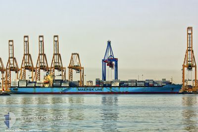
MAERSK KENTUCKY
Container Ship
Current Trip
| Time Travelled | 2 days |
|---|---|
| Remaining Time | 5 h, 4 mins |
| Distance Travelled | 652.83 nm |
| Remaining Distance | 298.40 nm |
| AVG Speed | 17.6 Knots |
| MAX Speed | 19.9 Knots |
| AVG Wind | 4.7 knots |
| MAX Wind | 10 knots |
| MIN Temp | 24.5°C / 76.1°F |
| MAX Temp | 27.3°C / 81.14°F |
| Dybgang | 12.4 m |
| Position Modtaget | 1 d siden |
Current Position
| Longitude | 57.30727° |
|---|---|
| Latitude | 24.94825° |
| Status | Moored |
| Fart | 17.6 Knots |
| Kurs | 129.2° |
| Område | Gulf of Oman |
| Station | T-AIS |
| Position Modtaget | 1 d siden |
Info
Information
The current position of MAERSK KENTUCKY is in Gulf of Oman with coordinates 24.94825° / 57.30727° as reported on 2025-03-12 01:46 by AIS to our vessel tracker app. The vessel's current speed is 17.6 Knots and is heading at the port of SALALAH. The estimated time of arrival as calculated by MyShipTracking vessel tracking app is 2025-03-13 18:37 LT
The vessel MAERSK KENTUCKY (IMO: 9193240, MMSI: 563073800) is a Container Ship that was built in 1999 ( 26 år gamle ). It's sailing under the flag of [SG] Singapore.
In this page you can find informations about the vessels current position, last detected port calls, and current voyage information. If the vessels is not in coverage by AIS you will find the latest position.
The current position of MAERSK KENTUCKY is detected by our AIS receivers and we are not responsible for the reliability of the data. The last position was recorded while the vessel was in Coverage by the Ais receivers of our vessel tracking app.
The current draught of MAERSK KENTUCKY as reported by AIS is 12.4 meters
Weather
| Temperature | 26.2°C / 79.16°F |
|---|---|
| Wind Speed | 4 knots |
| Direction | 203° SSW |
| Pressure | 1013.1 hPa |
| Humidity | 70.7 % |
| Cloud Coverage | --- |
Featured Company
Last Port Calls
| Port | Arrival | Departure | Time In Port |
|---|---|---|---|
| 2025-03-10 09:31 | 2025-03-11 11:04 | 1 d | |
| 2025-03-07 05:50 | 2025-03-07 20:00 | 14 h | |
| 2025-02-10 16:27 | 2025-02-11 14:38 | 22 h | |
| 2025-02-09 18:13 | 2025-02-10 16:16 | 22 h | |
| 2025-02-03 13:09 | 2025-02-04 20:13 | 1 d | |
| 2025-01-28 14:23 | 2025-01-29 08:46 | 18 h | |
| 2025-01-03 01:11 |
Last Trips
| Origin | Departure | Destination | Arrival | Distance | |
|---|---|---|---|---|---|
| 2025-03-08 00:00 | 2025-03-10 13:31 | 988.06 nm | |||
| 2025-02-11 15:38 | 2025-03-07 09:50 | 9466.49 nm | |||
| 2025-02-10 17:16 | 2025-02-10 17:27 | 1.03 nm | |||
| 2025-01-29 09:46 | 2025-02-09 19:13 | 3891.92 nm | |||
| 2025-01-29 09:46 | 2025-02-03 15:09 | 1941.25 nm | |||
| 2025-01-03 05:11 | 2025-01-28 15:23 | 9526.46 nm |
Events
| Tid | Hændelsen | Detaljer | Position / Dest | Info |
|---|---|---|---|---|
| 2025-03-12 01:51 | Status er ændret | Default Moored |
24.93331 / 57.32750
AEJAL>OMSLL
|
Fart: 17.6 kn Kurs: 129.2° |
| 2025-03-12 01:46 | Udenfor Dækning |
24.94825 / 57.30727
Gulf of Oman
AEJAL>OMSLL
|
Fart: 17.6 kn Kurs: 129.2° |
|
| 2025-03-12 00:58 | Ændre havområde | Omani part of the Gulf of Oman United Arab Emirates part of the Gulf of Oman |
25.10592 / 57.11649
Gulf of Oman
AEJAL>OMSLL
|
Fart: 17.4 kn Kurs: 142.4° |
| 2025-03-12 00:46 | Ændre havområde | United Arab Emirates part of the Gulf of Oman Iranian part of the Gulf of Oman |
25.15794 / 57.08642
Gulf of Oman
AEJAL>OMSLL
|
Fart: 17.6 kn Kurs: 155.5° |
| 2025-03-11 22:58 | Ændre havområde | Iranian part of the Gulf of Oman Omani part of the Gulf of Oman |
25.64870 / 56.84554
Gulf of Oman
AEJAL>OMSLL
|
Fart: 17.3 kn Kurs: 158.6° |
| 2025-03-11 22:01 | Ændre havområde | Omani part of the Gulf of Oman Omani part of the Persian Gulf |
25.91022 / 56.75706
Gulf of Oman
AEJAL>OMSLL
|
Fart: 17.7 kn Kurs: 163.5° |
| 2025-03-11 22:01 | Status er ændret | Moored Default |
25.91252 / 56.75632
AEJAL>OMSLL
|
Fart: 17.8 kn Kurs: 163° |
| 2025-03-11 22:01 | Indenfor Dækning |
25.91022 / 56.75706
Gulf of Oman
AEJAL>OMSLL
|
Fart: 17.7 kn Kurs: 163.5° |
|
| 2025-03-11 17:26 | Status er ændret | Default Moored |
26.24504 / 55.96348
AEJAL>OMSLL
|
Fart: 17.4 kn Kurs: 52.5° |
| 2025-03-11 17:18 | Udenfor Dækning |
26.22180 / 55.92929
Persian Gulf
AEJAL>OMSLL
|
Fart: 17.4 kn Kurs: 52.5° |