
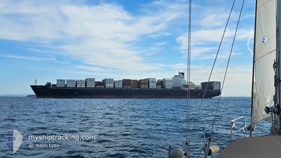
MSC TIANJIN
Container Ship
Current Trip
| Time Travelled | 11 h, 50 mins |
|---|---|
| Remaining Time | --- |
| Distance Travelled | 135.39 nm |
| Remaining Distance | 17.47 nm |
| AVG Speed | 12.9 Knots |
| MAX Speed | 14 Knots |
| AVG Wind | 14.1 knots |
| MAX Wind | 18 knots |
| MIN Temp | 12.8°C / 55.04°F |
| MAX Temp | 14.2°C / 57.56°F |
| Dybgang | 13.3 m |
| Position Modtaget | 4 d siden |
Current Position
| Longitude | 32.30973° |
|---|---|
| Latitude | 31.04418° |
| Status | Under way using engine |
| Fart | 9.5 Knots |
| Kurs | 1° |
| Område | Gulf of Suez |
| Station | T-AIS |
| Position Modtaget | 4 d siden |
Info
Information
The current position of MSC TIANJIN is in Gulf of Suez with coordinates 31.04418° / 32.30973° as reported on 2025-02-03 12:36 by AIS to our vessel tracker app. The vessel's current speed is 9.5 Knots and is heading at the port of ABU QIR. The estimated time of arrival as calculated by MyShipTracking vessel tracking app is 2025-02-03 19:00 LT
The vessel MSC TIANJIN (IMO: 9285471, MMSI: 636019332) is a Container Ship that was built in 2005 ( 20 år gamle ). It's sailing under the flag of [LR] Liberia.
In this page you can find informations about the vessels current position, last detected port calls, and current voyage information. If the vessels is not in coverage by AIS you will find the latest position.
The current position of MSC TIANJIN is detected by our AIS receivers and we are not responsible for the reliability of the data. The last position was recorded while the vessel was in Coverage by the Ais receivers of our vessel tracking app.
The current draught of MSC TIANJIN as reported by AIS is 13.3 meters
Weather
| Temperature | 13.7°C / 56.66°F |
|---|---|
| Wind Speed | 16 knots |
| Direction | 357° N |
| Pressure | 1023.8 hPa |
| Humidity | 56.8 % |
| Cloud Coverage | 100 % |
Featured Company
Last Port Calls
| Port | Arrival | Departure | Time In Port |
|---|---|---|---|
| 2025-02-03 23:04 | 2025-02-07 10:24 | 3 d | |
| 2025-02-03 04:35 | 2025-02-03 13:57 | 9 h | |
| 2025-01-31 20:21 | 2025-02-02 02:45 | 1 d | |
| 2025-01-29 08:25 | 2025-01-30 03:47 | 19 h | |
| 2025-01-27 03:30 | 2025-01-29 02:08 | 1 d | |
| 2025-01-26 02:25 | 2025-01-26 21:36 | 19 h | |
| 2025-01-24 05:05 | 2025-01-24 14:03 | 8 h | |
| 2025-01-22 10:35 | 2025-01-23 10:14 | 23 h | |
| 2025-01-19 23:30 | 2025-01-20 17:42 | 18 h | |
| 2025-01-15 16:13 | 2025-01-16 21:23 | 1 d |
Most Visited Ports (Last year)
| Port | Arrivals | |
|---|---|---|
| 6 | ||
| 5 | ||
| 4 | ||
| 3 | ||
| 3 | ||
| 3 |
Last Trips
| Origin | Departure | Destination | Arrival | Distance | |
|---|---|---|---|---|---|
| 2025-02-02 04:45 | 2025-02-04 01:04 | 474.75 nm | |||
| 2025-02-02 04:45 | 2025-02-03 06:35 | 303.96 nm | |||
| 2025-01-30 06:47 | 2025-01-31 22:21 | 547.03 nm | |||
| 2025-01-29 05:08 | 2025-01-29 11:25 | 85.34 nm | |||
| 2025-01-27 00:36 | 2025-01-27 06:30 | 87.32 nm | |||
| 2025-01-23 12:14 | 2025-01-26 05:25 | 868.97 nm | |||
| 2025-01-23 12:14 | 2025-01-24 07:05 | 177.76 nm | |||
| 2025-01-20 18:42 | 2025-01-22 12:35 | 825.99 nm | |||
| 2025-01-16 22:23 | 2025-01-20 00:30 | 313.91 nm | |||
| 2025-01-13 21:54 | 2025-01-15 17:13 | 764.61 nm |
Events
| Tid | Hændelsen | Detaljer | Position / Dest | Info |
|---|---|---|---|---|
| 2025-02-07 10:24 | Afsejlet fra sidste havn |
|
31.51888 / 31.76567
EGAKI
|
Fart: 8.4 kn Kurs: 12° |
| 2025-02-07 10:02 | START Sejllads |
31.46483 / 31.75733
[EG] DAMIETTA
|
Fart: 3.8 kn Kurs: 317° |
|
| 2025-02-03 23:45 | STOP Sejllads |
31.45982 / 31.75995
[EG] DAMIETTA
|
Fart: 0.1 kn Kurs: 138° |
|
| 2025-02-03 23:04 | Skibe i havn |
|
31.49152 / 31.75968
[EG] DAMIETTA
|
Fart: 9.1 kn Kurs: 192° |
| 2025-02-03 22:04 | START Sejllads | 10.88 nm, North of DAMIETTA |
31.64872 / 31.77303
EGAKI
|
Fart: 8.6 kn Kurs: 139° |
| 2025-02-03 20:12 | STOP Sejllads | 10.91 nm, North of DAMIETTA |
31.64905 / 31.77597
EGAKI
|
Fart: 0.3 kn Kurs: 141° |
| 2025-02-03 13:57 | Afsejlet fra sidste havn |
|
31.24438 / 32.35047
EGAKI
|
Fart: 10.7 kn Kurs: 15° |
| 2025-02-03 12:41 | Status er ændret | Default Under way using engine |
31.05690 / 32.30953
[EG] SUEZ CANAL
|
Fart: 9.5 kn Kurs: 1° |
| 2025-02-03 12:36 | Udenfor Dækning |
31.04418 / 32.30973
Gulf of Suez
[EG] SUEZ CANAL
|
Fart: 9.5 kn Kurs: 358° |
|
| 2025-02-03 12:30 | Status er ændret | Under way using engine Default |
31.02710 / 32.31032
[EG] SUEZ CANAL
|
Fart: 9.5 kn Kurs: 1° |