

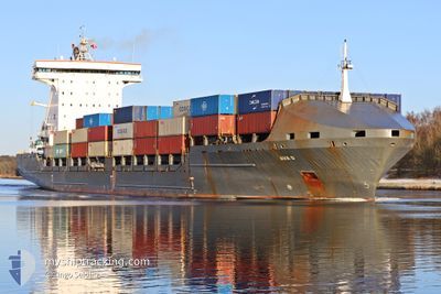
AVA D
Container Ship

Current Trip
| Time Travelled | 4 days |
|---|---|
| Remaining Time | --- |
| Distance Travelled | 1061.04 nm |
| Remaining Distance | 3.96 nm |
| AVG Speed | 13.3 Noeuds |
| MAX Speed | 18.1 Noeuds |
| AVG Wind | 13.1 knots |
| MAX Wind | 29.8 knots |
| MIN Temp | -0.9°C / 30.38°F |
| MAX Temp | 8.2°C / 46.76°F |
| Tirant d eau | 8.9 m |
| Position reçue | 1 d depuis |
Current Position
| Longitude | 22.44591° |
|---|---|
| Latitude | 59.45484° |
| Etat | Under way using engine |
| Vitesse | 17.8 Noeuds |
| Parcours | 234.7° |
| Zone | Baltic Sea |
| Station | T-AIS |
| Position reçue | 1 d depuis |
Information
The current position of AVA D is in Baltic Sea with coordinates 59.45484° / 22.44591° as reported on 2025-04-05 02:35 by AIS to our vessel tracker app. The vessel's current speed is 17.8 Noeuds and is heading at the port of RIGA. The estimated time of arrival as calculated by MyShipTracking vessel tracking app is 2025-04-04 18:30 LT
The vessel AVA D (IMO: 9306225, MMSI: 255705000) is a Container Ship that was built in 2007 ( 18 Age ). It's sailing under the flag of [PT] Portugal.
In this page you can find informations about the vessels current position, last detected port calls, and current voyage information. If the vessels is not in coverage by AIS you will find the latest position.
The current position of AVA D is detected by our AIS receivers and we are not responsible for the reliability of the data. The last position was recorded while the vessel was in Coverage by the Ais receivers of our vessel tracking app.
The current draught of AVA D as reported by AIS is 8.9 meters
Weather
| Temperature | 0.1°C / 32.18°F |
|---|---|
| Wind Speed | 13 knots |
| Direction | 20° NNE |
| Pressure | 1021 hPa |
| Humidity | 41.4 % |
| Cloud Coverage | 7 % |


Featured Company
Last Port Calls
| Port | Arrival | Departure | Time In Port |
|---|---|---|---|
| 2025-04-01 20:34 | 2025-04-01 20:38 | 3 m | |
| 2025-03-27 21:42 | 2025-03-31 07:25 | 3 d | |
| 2025-03-14 09:56 | 2025-03-14 21:12 | 11 h | |
| 2025-03-13 15:35 | 2025-03-14 09:44 | 18 h | |
| 2025-03-12 05:03 | 2025-03-13 15:22 | 1 d | |
| 2025-03-12 03:18 | 2025-03-12 03:29 | 11 m | |
| 2025-03-11 18:45 | 2025-03-12 03:16 | 8 h | |
| 2025-02-28 11:36 | 2025-02-28 17:57 | 6 h | |
| 2025-02-24 00:36 | 2025-02-28 11:33 | 4 d | |
| 2025-02-23 22:52 | 2025-02-23 23:06 | 14 m |
Most Visited Ports (Last year)
| Port | Arrivals | |
|---|---|---|
| 31 | ||
| 13 | ||
| 12 | ||
| 12 | ||
| 8 | ||
| 6 |
Last Trips
| Origin | Departure | Destination | Arrival | Distance | |
|---|---|---|---|---|---|
| 2025-03-31 07:25 | 2025-04-01 20:34 | 319.19 nm | |||
| 2025-03-14 21:12 | 2025-03-27 21:42 | 2380.81 nm | |||
| 2025-03-14 09:44 | 2025-03-14 09:56 | 1.39 nm | |||
| 2025-03-13 15:22 | 2025-03-13 15:35 | 2.49 nm | |||
| 2025-03-12 03:29 | 2025-03-12 05:03 | 15.30 nm | |||
| 2025-03-12 03:16 | 2025-03-12 03:18 | 0.07 nm | |||
| 2025-02-28 17:57 | 2025-03-11 18:45 | 2080.26 nm | |||
| 2025-02-28 11:33 | 2025-02-28 11:36 | 0.34 nm | |||
| 2025-02-23 23:06 | 2025-02-24 00:36 | 15.45 nm | |||
| 2025-02-23 22:50 | 2025-02-23 22:52 | 0.03 nm |
Events
| Heure | Evenement | Détails | Position/ Destination | Info |
|---|---|---|---|---|
| 2025-04-06 07:26 | Démarrage | 12.91 nm, North West of RIGA |
57.12722 / 23.87897
RIGA
|
Vitesse: 4.1 kn Parcours: 124° |
| 2025-04-05 18:09 | Arret | 12.81 nm, North West of RIGA |
57.12338 / 23.87413
RIGA
|
Vitesse: 0.2 kn Parcours: 4° |
| 2025-04-05 02:37 | Etat Changé | Default Under way using engine |
59.44757 / 22.42495
RIGA
|
Vitesse: 17.8 kn Parcours: 234.7° |
| 2025-04-05 02:35 | Hors de la zone couverte |
59.45484 / 22.44591
Baltic Sea
|
Vitesse: 17.8 kn Parcours: 234.7° |
|
| 2025-04-05 01:26 | Changement de zone | Finnish part of the Baltic Sea Finnish part of the Gulf of Finland |
59.57401 / 23.06862
Baltic Sea
|
Vitesse: 18 kn Parcours: 250.6° |
| 2025-04-04 22:35 | Changement de zone | Finnish part of the Gulf of Finland Estonian part of the Gulf of Finland |
59.80857 / 24.68591
Gulf of Finland
|
Vitesse: 17.7 kn Parcours: 259.4° |
| 2025-04-04 21:26 | Changement de zone | Estonian part of the Gulf of Finland Finnish part of the Gulf of Finland |
59.87774 / 25.34230
Gulf of Finland
|
Vitesse: 17.5 kn Parcours: 258.1° |
| 2025-04-04 20:22 | Etat Changé | Under way using engine Default |
59.98453 / 25.91232
RIGA
|
Vitesse: 17.5 kn Parcours: 232° |
| 2025-04-04 19:50 | Etat Changé | Default Under way using engine |
60.08216 / 26.15222
RIGA
|
Vitesse: 17.5 kn Parcours: 233.8° |
| 2025-04-04 19:22 | Changement d'ETA | 2025/04/04 15:30 2025/04/04 19:00 |
60.17414 / 26.35720
RIGA
|
Vitesse: 17.4 kn Parcours: 206.4° |