
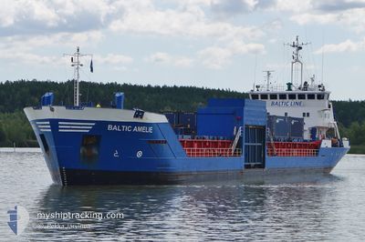
BALTIC AMELIE
General Cargo
Current Trip
| Time Travelled | 23 h, 54 mins |
|---|---|
| Remaining Time | 1 day |
| Distance Travelled | 204.40 nm |
| Remaining Distance | 396.41 nm |
| AVG Speed | 8 Noeuds |
| MAX Speed | 10.2 Noeuds |
| AVG Wind | 18.3 knots |
| MAX Wind | 21.3 knots |
| MIN Temp | 0.4°C / 32.72°F |
| MAX Temp | 4.1°C / 39.38°F |
| Tirant d eau | 4.6 m |
| Position reçue | 37 m depuis |
Current Position
| Longitude | 18.21148° |
|---|---|
| Latitude | 57.95442° |
| Etat | Under way using engine |
| Vitesse | 9.9 Noeuds |
| Parcours | 222.4° |
| Zone | Baltic Sea |
| Station | T-AIS |
| Position reçue | 37 m depuis |
Info
Information
The current position of BALTIC AMELIE is in Baltic Sea with coordinates 57.95442° / 18.21148° as reported on 2025-02-22 14:27 by AIS to our vessel tracker app. The vessel's current speed is 9.9 Noeuds and is heading at the port of NYBORG. The estimated time of arrival as calculated by MyShipTracking vessel tracking app is 2025-02-24 07:33 LT
The vessel BALTIC AMELIE (IMO: 9083885, MMSI: 230091950) is a General Cargo that was built in 1994 ( 31 Age ). It's sailing under the flag of [FI] Finland.
In this page you can find informations about the vessels current position, last detected port calls, and current voyage information. If the vessels is not in coverage by AIS you will find the latest position.
The current position of BALTIC AMELIE is detected by our AIS receivers and we are not responsible for the reliability of the data. The last position was recorded while the vessel was in Coverage by the Ais receivers of our vessel tracking app.
The current draught of BALTIC AMELIE as reported by AIS is 4.6 meters
Weather
| Temperature | 3.1°C / 37.58°F |
|---|---|
| Wind Speed | 21 knots |
| Direction | 180° S |
| Pressure | 1020.9 hPa |
| Humidity | 85.6 % |
| Cloud Coverage | 100 % |
Featured Company
Last Port Calls
| Port | Arrival | Departure | Time In Port |
|---|---|---|---|
| 2025-02-16 22:05 | 2025-02-21 17:10 | 4 d | |
| 2025-02-12 10:28 | 2025-02-12 17:11 | 6 h | |
| 2025-02-11 14:39 | 2025-02-11 19:56 | 5 h | |
| 2025-02-10 08:17 | 2025-02-10 12:53 | 4 h | |
| 2025-02-05 10:04 | 2025-02-07 16:50 | 2 d | |
| 2025-01-31 17:55 | 2025-02-02 00:47 | 1 d | |
| 2025-01-27 06:31 | 2025-01-28 16:58 | 1 d | |
| 2025-01-23 00:28 | 2025-01-23 09:16 | 8 h | |
| 2025-01-22 19:21 | 2025-01-22 20:55 | 1 h | |
| 2025-01-22 12:39 | 2025-01-22 19:11 | 6 h |
Last Trips
| Origin | Departure | Destination | Arrival | Distance | |
|---|---|---|---|---|---|
| 2025-02-12 17:11 | 2025-02-16 22:05 | 879.07 nm | |||
| 2025-02-11 19:56 | 2025-02-12 10:28 | 145.72 nm | |||
| 2025-02-10 12:53 | 2025-02-11 14:39 | 257.40 nm | |||
| 2025-02-07 16:50 | 2025-02-10 08:17 | 599.84 nm | |||
| 2025-02-02 00:47 | 2025-02-05 10:04 | 744.55 nm | |||
| 2025-01-28 16:58 | 2025-01-31 17:55 | 738.71 nm | |||
| 2025-01-23 09:16 | 2025-01-27 06:31 | 872.60 nm | |||
| 2025-01-22 20:55 | 2025-01-23 00:28 | 37.31 nm | |||
| 2025-01-22 19:11 | 2025-01-22 19:21 | 1.17 nm | |||
| 2025-01-22 00:27 | 2025-01-22 12:39 | 107.90 nm |
Events
| Heure | Evenement | Détails | Position/ Destination | Info |
|---|---|---|---|---|
| 2025-02-22 14:34 | Etat Changé | Default Under way using engine |
57.94100 / 18.18881
DKNBG
|
Vitesse: 9.9 kn Parcours: 222.4° |
| 2025-02-22 14:27 | Detecté en mer | Swedish part of the Baltic Sea |
57.95442 / 18.21148
Baltic Sea
DKNBG
|
Vitesse: 9.9 kn Parcours: 222.4° |
| 2025-02-22 14:27 | Etat Changé | Under way using engine Default |
57.95496 / 18.21240
DKNBG
|
Vitesse: 9.9 kn Parcours: 222° |
| 2025-02-22 14:17 | Dans la zone couverte |
57.95442 / 18.21148
Baltic Sea
DKNBG
|
Vitesse: 9.9 kn Parcours: 222.4° |
|
| 2025-02-21 22:26 | Etat Changé | Default Under way using engine |
59.61474 / 21.15482
DKNBG
|
Vitesse: 7.2 kn Parcours: 223.6° |
| 2025-02-21 22:20 | Hors de la zone couverte |
59.62415 / 21.17141
Baltic Sea
DKNBG
|
Vitesse: 7.2 kn Parcours: 223.6° |
|
| 2025-02-21 21:19 | Changement de zone | Finnish part of the Baltic Sea Finnish part of the Gulf of Bothnia |
59.70495 / 21.32520
Baltic Sea
DKNBG
|
Vitesse: 6.3 kn Parcours: 224.2° |
| 2025-02-21 19:46 | Etat Changé | Under way using engine Default |
59.87846 / 21.49918
DKNBG
|
Vitesse: 10 kn Parcours: 233° |
| 2025-02-21 19:33 | Dans la zone couverte |
59.87797 / 21.49765
Gulf of Bothnia
DKNBG
|
Vitesse: 9.8 kn Parcours: 238.3° |
|
| 2025-02-21 18:37 | Hors de la zone couverte |
60.02286 / 21.69500
Gulf of Bothnia
DKNBG
|
Vitesse: 10 kn Parcours: 165.6° |