
BLUE RIDGE HIGHWAY
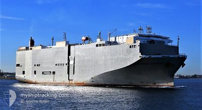
Vehicles Carrier
Current Trip
| Time Travelled | 1 day |
|---|---|
| Remaining Time | 2 days |
| Distance Travelled | 518.75 nm |
| Remaining Distance | 861.90 nm |
| AVG Speed | 16.1 Noeuds |
| MAX Speed | 17.1 Noeuds |
| AVG Wind | 11.1 knots |
| MAX Wind | 17 knots |
| MIN Temp | 20.2°C / 68.36°F |
| MAX Temp | 26.1°C / 78.98°F |
| Tirant d eau | 8.5 m |
| Position reçue | 7 h, 32 m depuis |
Current Position
| Longitude | -108.32183° |
|---|---|
| Latitude | 20.88873° |
| Etat | Under way using engine |
| Vitesse | 16.2 Noeuds |
| Parcours | 302.2° |
| Zone | North Pacific Ocean |
| Station | T-AIS |
| Position reçue | 7 h, 32 m depuis |
Info
Information
The current position of BLUE RIDGE HIGHWAY is in North Pacific Ocean with coordinates 20.88873° / -108.32183° as reported on 2025-03-21 01:41 by AIS to our vessel tracker app. The vessel's current speed is 16.2 Noeuds and is heading at the port of LOS ANGELES. The estimated time of arrival as calculated by MyShipTracking vessel tracking app is 2025-03-23 06:16 LT
The vessel BLUE RIDGE HIGHWAY (IMO: 9510151, MMSI: 355558000) is a Vehicles Carrier that was built in 2009 ( 16 Age ). It's sailing under the flag of [PA] Panama.
In this page you can find informations about the vessels current position, last detected port calls, and current voyage information. If the vessels is not in coverage by AIS you will find the latest position.
The current position of BLUE RIDGE HIGHWAY is detected by our AIS receivers and we are not responsible for the reliability of the data. The last position was recorded while the vessel was in Coverage by the Ais receivers of our vessel tracking app.
The current draught of BLUE RIDGE HIGHWAY as reported by AIS is 8.5 meters
Weather
| Temperature | 19.9°C / 67.82°F |
|---|---|
| Wind Speed | 7 knots |
| Direction | 329° NNW |
| Pressure | 1013.7 hPa |
| Humidity | 64 % |
| Cloud Coverage | 100 % |
Featured Company
Last Port Calls
| Port | Arrival | Departure | Time In Port |
|---|---|---|---|
| 2025-03-18 05:35 | 2025-03-19 18:36 | 1 d | |
| 2025-03-09 05:50 | 2025-03-09 17:29 | 11 h | |
| 2025-02-28 06:02 | 2025-02-28 16:17 | 10 h | |
| 2025-02-27 06:42 | 2025-02-27 15:44 | 9 h | |
| 2025-02-23 06:33 | 2025-02-23 17:21 | 10 h | |
| 2025-02-14 21:19 | 2025-02-15 02:21 | 5 h | |
| 2025-02-12 13:16 | 2025-02-13 01:56 | 12 h | |
| 2025-01-29 23:50 | 2025-01-31 07:32 | 1 d | |
| 2025-01-18 08:46 | 2025-01-18 17:19 | 8 h | |
| 2025-01-16 15:51 | 2025-01-16 20:25 | 4 h |
Most Visited Ports (Last year)
| Port | Arrivals | |
|---|---|---|
| 19 | ||
| 17 | ||
| 9 | ||
| 9 | ||
| 8 | ||
| 2 |
Last Trips
| Origin | Departure | Destination | Arrival | Distance | |
|---|---|---|---|---|---|
| 2025-03-09 17:29 | 2025-03-18 05:35 | 3179.04 nm | |||
| 2025-02-28 16:17 | 2025-03-09 05:50 | 3603.31 nm | |||
| 2025-02-27 15:44 | 2025-02-28 06:02 | 201.06 nm | |||
| 2025-02-23 17:21 | 2025-02-27 06:42 | 380.90 nm | |||
| 2025-02-15 02:21 | 2025-02-23 06:33 | 2822.97 nm | |||
| 2025-02-13 01:56 | 2025-02-14 21:19 | 647.66 nm | |||
| 2025-01-31 07:32 | 2025-02-12 13:16 | 4588.29 nm | |||
| 2025-01-18 17:19 | 2025-01-29 23:50 | 4148.18 nm | |||
| 2025-01-16 20:25 | 2025-01-18 08:46 | 494.21 nm | |||
| 2025-01-12 21:51 | 2025-01-16 15:51 | 1391.53 nm |
Events
| Heure | Evenement | Détails | Position/ Destination | Info |
|---|---|---|---|---|
| 2025-03-21 01:47 | Etat Changé | Default Under way using engine |
20.90230 / -108.34444
US LGB
|
Vitesse: 16.2 kn Parcours: 302.2° |
| 2025-03-21 01:41 | Hors de la zone couverte |
20.88873 / -108.32183
North Pacific Ocean
US LGB
|
Vitesse: 16.2 kn Parcours: 302.2° |
|
| 2025-03-21 01:26 | Etat Changé | Under way using engine Default |
20.85312 / -108.26299
US LGB
|
Vitesse: 15.8 kn Parcours: 303° |
| 2025-03-21 01:22 | Etat Changé | Default Under way using engine |
20.84291 / -108.24584
US LGB
|
Vitesse: 15.9 kn Parcours: 304° |
| 2025-03-20 23:45 | Etat Changé | Under way using engine Default |
20.61815 / -107.85009
US LGB
|
Vitesse: 16.1 kn Parcours: 302° |
| 2025-03-20 23:38 | Etat Changé | Default Under way using engine |
20.60208 / -107.82263
US LGB
|
Vitesse: 16.2 kn Parcours: 301.6° |
| 2025-03-20 23:29 | Etat Changé | Under way using engine Default |
20.57950 / -107.78352
US LGB
|
Vitesse: 16.2 kn Parcours: 302° |
| 2025-03-20 23:24 | Etat Changé | Default Under way using engine |
20.56882 / -107.76523
US LGB
|
Vitesse: 16.2 kn Parcours: 300.7° |
| 2025-03-20 23:08 | Etat Changé | Under way using engine Default |
20.53253 / -107.70119
US LGB
|
Vitesse: 16.3 kn Parcours: 301° |
| 2025-03-20 22:50 | Etat Changé | Default Under way using engine |
20.49018 / -107.62462
US LGB
|
Vitesse: 16 kn Parcours: 300.3° |