
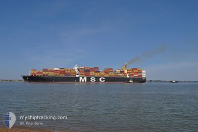
MSC GAIA
Container Ship
Current Trip
| Time Travelled | 6 days |
|---|---|
| Remaining Time | 8 days |
| Distance Travelled | 2830.60 nm |
| Remaining Distance | 3589.96 nm |
| AVG Speed | 17.9 Noeuds |
| MAX Speed | 20.8 Noeuds |
| AVG Wind | 11.5 knots |
| MAX Wind | 18.2 knots |
| MIN Temp | 18.2°C / 64.76°F |
| MAX Temp | 28.4°C / 83.12°F |
| Tirant d eau | 10.9 m |
| Position reçue | 11 h, 49 m depuis |
Current Position
| Longitude | 89.19939° |
|---|---|
| Latitude | 5.75265° |
| Etat | Under way using engine |
| Vitesse | 17.9 Noeuds |
| Parcours | 89.8° |
| Zone | Bay of Bengal |
| Station | T-AIS |
| Position reçue | 11 h, 49 m depuis |
Info
Information
The current position of MSC GAIA is in Bay of Bengal with coordinates 5.75265° / 89.19939° as reported on 2025-02-05 08:41 by AIS to our vessel tracker app. The vessel's current speed is 17.9 Noeuds and is heading at the port of TIANJIN. The estimated time of arrival as calculated by MyShipTracking vessel tracking app is 2025-02-14 14:28 LT
The vessel MSC GAIA (IMO: 9401142, MMSI: 353051000) is a Container Ship that was built in 2010 ( 15 Age ). It's sailing under the flag of [PA] Panama.
In this page you can find informations about the vessels current position, last detected port calls, and current voyage information. If the vessels is not in coverage by AIS you will find the latest position.
The current position of MSC GAIA is detected by our AIS receivers and we are not responsible for the reliability of the data. The last position was recorded while the vessel was in Coverage by the Ais receivers of our vessel tracking app.
The current draught of MSC GAIA as reported by AIS is 10.9 meters
Weather
| Temperature | 27.6°C / 81.68°F |
|---|---|
| Wind Speed | 12 knots |
| Direction | 50° NE |
| Pressure | 1008.3 hPa |
| Humidity | 76.8 % |
| Cloud Coverage | 37 % |
Featured Company
Last Port Calls
| Port | Arrival | Departure | Time In Port |
|---|---|---|---|
| 2025-01-29 17:36 | 2025-01-30 20:23 | 1 d | |
| 2025-01-22 18:53 | 2025-01-26 22:25 | 4 d | |
| 2025-01-15 04:28 | 2025-01-16 08:11 | 1 d | |
| 2025-01-13 17:57 | 2025-01-14 22:37 | 1 d | |
| 2025-01-03 21:41 | 2025-01-04 20:32 | 22 h | |
| 2024-12-26 17:00 | 2024-12-26 23:20 | 6 h | |
| 2024-12-16 01:05 | 2024-12-16 21:46 | 20 h | |
| 2024-12-10 15:57 | 2024-12-12 13:36 | 1 d | |
| 2024-12-07 02:34 | 2024-12-08 15:38 | 1 d |
Most Visited Ports (Last year)
| Port | Arrivals | |
|---|---|---|
| 10 | ||
| 7 | ||
| 7 | ||
| 5 | ||
| 4 | ||
| 2 |
Last Trips
| Origin | Departure | Destination | Arrival | Distance | |
|---|---|---|---|---|---|
| 2025-01-26 22:25 | 2025-01-29 17:36 | 516.90 nm | |||
| 2025-01-16 08:11 | 2025-01-22 18:53 | 749.79 nm | |||
| 2025-01-14 22:37 | 2025-01-15 04:28 | 46.52 nm | |||
| 2025-01-04 20:32 | 2025-01-13 17:57 | 3636.14 nm | |||
| 2024-12-26 23:20 | 2025-01-03 21:41 | 2343.13 nm | |||
| 2024-12-16 21:46 | 2024-12-26 17:00 | 1480.01 nm | |||
| 2024-12-12 13:36 | 2024-12-16 01:05 | 1120.65 nm | |||
| 2024-12-08 15:38 | 2024-12-10 15:57 | 773.57 nm | |||
| 2024-11-20 05:31 | 2024-12-07 02:34 | 6689.21 nm |
Events
| Heure | Evenement | Détails | Position/ Destination | Info |
|---|---|---|---|---|
| 2025-02-05 08:56 | Etat Changé | Default Under way using engine |
5.75345 / 89.27337
CNTXG
|
Vitesse: 17.9 kn Parcours: 89.8° |
| 2025-02-05 08:41 | Hors de la zone couverte |
5.75265 / 89.19939
Bay of Bengal
CNTXG
|
Vitesse: 17.9 kn Parcours: 89.8° |
|
| 2025-02-05 07:24 | Changement de zone | High seas of the Bay of Bengal Sri Lankan part of the Laccadive Sea |
5.75447 / 88.80806
Bay of Bengal
CNTXG
|
Vitesse: 18.2 kn Parcours: 88.3° |
| 2025-02-05 07:24 | Etat Changé | Under way using engine Default |
5.75447 / 88.80806
CNTXG
|
Vitesse: 18.3 kn Parcours: 88° |
| 2025-02-05 07:24 | Dans la zone couverte |
5.75447 / 88.80806
Bay of Bengal
CNTXG
|
Vitesse: 18.2 kn Parcours: 88.3° |
|
| 2025-02-04 01:36 | Etat Changé | Default Under way using engine |
5.66081 / 79.56692
CNTXG
|
Vitesse: 19.8 kn Parcours: 125.4° |
| 2025-02-04 01:34 | Hors de la zone couverte |
5.66819 / 79.55661
Laccadive Sea
CNTXG
|
Vitesse: 19.8 kn Parcours: 125.4° |
|
| 2025-02-04 00:35 | Etat Changé | Under way using engine Default |
5.85227 / 79.28375
CNTXG
|
Vitesse: 20.1 kn Parcours: 123° |
| 2025-02-04 00:04 | Etat Changé | Default Under way using engine |
5.94995 / 79.14478
CNTXG
|
Vitesse: 19.9 kn Parcours: 125.8° |
| 2025-02-03 23:59 | Etat Changé | Under way using engine Default |
5.96624 / 79.12220
CNTXG
|
Vitesse: 19.9 kn Parcours: 126° |