

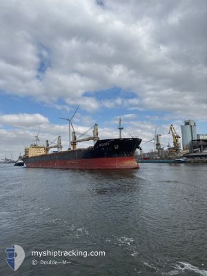
ACUITY
Bulk Carrier

Current Trip
| Time Travelled | 8 days |
|---|---|
| Remaining Time | --- |
| Distance Travelled | 1612.13 nm |
| Remaining Distance | --- |
| AVG Speed | 8.9 Knopen |
| MAX Speed | 15.8 Knopen |
| AVG Wind | 12 knots |
| MAX Wind | 29 knots |
| MIN Temp | 7.9°C / 46.22°F |
| MAX Temp | 18.9°C / 66.02°F |
| Diepgang | 9.4 M |
| Positie ontvangen | 47 m geleden |
Current Position
| Lengtegraad | -3.51969° |
|---|---|
| Breedtegraat | 36.21020° |
| Status | Under way using engine |
| Snelheid | 11.8 Knopen |
| Koers | 81.1° |
| Gebied | Alboran Sea |
| Station | T-AIS |
| Positie ontvangen | 47 m geleden |
Information
The current position of ACUITY is in Alboran Sea with coordinates 36.21020° / -3.51969° as reported on 2025-03-28 12:54 by AIS to our vessel tracker app. The vessel's current speed is 11.8 Knopen and is heading at the port of TSINGELI. The estimated time of arrival as calculated by MyShipTracking vessel tracking app is 2025-04-03 12:00 LT
The vessel ACUITY (IMO: 9486582, MMSI: 538004177) is a Bulk Carrier that was built in 2011 ( 14 Jaar oud ). It's sailing under the flag of [MH] Marshall Is.
In this page you can find informations about the vessels current position, last detected port calls, and current voyage information. If the vessels is not in coverage by AIS you will find the latest position.
The current position of ACUITY is detected by our AIS receivers and we are not responsible for the reliability of the data. The last position was recorded while the vessel was in Coverage by the Ais receivers of our vessel tracking app.
The current draught of ACUITY as reported by AIS is 9.4 meters
Weather
| Temperature | 16.3°C / 61.34°F |
|---|---|
| Wind Speed | 10 knots |
| Direction | 266° W |
| Pressure | 1016.8 hPa |
| Humidity | 74.1 % |
| Cloud Coverage | --- |


Featured Company
Most Visited Ports (Last year)
| Port | Arrivals | |
|---|---|---|
| 2 | ||
| 2 | ||
| 2 | ||
| 1 | ||
| 1 | ||
| 1 |
Last Trips
| Origin | Departure | Destination | Arrival | Distance | |
|---|---|---|---|---|---|
| 2025-03-20 10:49 | 2025-03-20 12:34 | 9.42 nm | |||
| 2025-03-17 11:44 | 2025-03-17 12:58 | 7.82 nm | |||
| 2025-03-14 17:55 | 2025-03-17 11:25 | 587.74 nm | |||
| 2025-01-09 22:48 | 2025-03-05 10:47 | 5510.64 nm | |||
| 2024-12-18 00:56 | 2025-01-07 07:42 | 2370.60 nm |
Events
| Tijd | Evenement | Details | Positie / Bestemming | Info |
|---|---|---|---|---|
| 2025-03-28 12:56 | Status Changed | Default Under way using engine |
36.21141 / -3.51027
TSINGELI, GREECE
|
Snelheid: 11.8 kn Koers: 81.1° |
| 2025-03-28 12:40 | Status Changed | Under way using engine Default |
36.20310 / -3.57469
TSINGELI, GREECE
|
Snelheid: 12.1 kn Koers: 81° |
| 2025-03-28 12:15 | Status Changed | Default Under way using engine |
36.19101 / -3.68042
TSINGELI, GREECE
|
Snelheid: 12.4 kn Koers: 84.1° |
| 2025-03-28 12:00 | Status Changed | Under way using engine Default |
36.18496 / -3.74280
TSINGELI, GREECE
|
Snelheid: 12.6 kn Koers: 78° |
| 2025-03-28 12:00 | Binnenbereik |
36.18563 / -3.73702
Alboran Sea
TSINGELI, GREECE
|
Snelheid: 12.5 kn Koers: 81.4° |
|
| 2025-03-28 07:06 | Status Changed | Default Under way using engine |
36.02468 / -4.99862
TSINGELI, GREECE
|
Snelheid: 12.2 kn Koers: 84.4° |
| 2025-03-28 07:02 | Buitenbereik |
36.02312 / -5.01692
Alboran Sea
TSINGELI, GREECE
|
Snelheid: 12.2 kn Koers: 84.4° |
|
| 2025-03-28 06:49 | Wijzig zee gebeid | Spanish part of the Alboran Sea Gibraltarian part of the Strait of Gibraltar |
36.01948 / -5.06793
Alboran Sea
TSINGELI, GREECE
|
Snelheid: 12.1 kn Koers: 88.2° |
| 2025-03-28 06:47 | Status Changed | Under way using engine Default |
36.01941 / -5.07629
TSINGELI, GREECE
|
Snelheid: 13.5 kn Koers: 89° |
| 2025-03-28 05:44 | Buitenbereik |
36.07843 / -5.34708
Strait of Gibraltar
TSINGELI, GREECE
|
Snelheid: 10.8 kn Koers: 112.4° |