
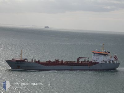
ATLANTIC MATE
Oil/Chemical Tanker
Current Trip
| Trip Time | 18 h, 21 mins |
|---|---|
| Trip Distance | 170.83 nm |
| AVG Speed | 9.6 Knopen |
| MAX Speed | 14 Knopen |
| Diepgang | 9.5 M |
| AVG Wind | 7.4 knots |
| MAX Wind | 12.5 knots |
| MIN Temp | 3.3°C / 37.94°F |
| MAX Temp | 5.6°C / 42.08°F |
| Positie ontvangen | Nu |
Current Position
| Lengtegraad | 0.30239° |
|---|---|
| Breedtegraat | 51.47177° |
| Status | Moored |
| Snelheid | |
| Koers | 257° |
| Gebied | North Sea |
| Station | T-AIS |
| Positie ontvangen | Nu |
Info
Information
The current position of ATLANTIC MATE is in North Sea with coordinates 51.47177° / 0.30239° as reported on 2025-02-13 10:37 by AIS to our vessel tracker app. The vessel's current speed is 0 Knopen and is currently inside the port of SOUTH STIFFORD.
The vessel ATLANTIC MATE (IMO: 9350745, MMSI: 236683000) is a Oil/Chemical Tanker that was built in 2007 ( 18 Jaar oud ). It's sailing under the flag of [GI] Gibraltar.
In this page you can find informations about the vessels current position, last detected port calls, and current voyage information. If the vessels is not in coverage by AIS you will find the latest position.
The current position of ATLANTIC MATE is detected by our AIS receivers and we are not responsible for the reliability of the data. The last position was recorded while the vessel was in Coverage by the Ais receivers of our vessel tracking app.
The current draught of ATLANTIC MATE as reported by AIS is 9.5 meters
Weather
| Temperature | 4°C / 39.2°F |
|---|---|
| Wind Speed | 7 knots |
| Direction | 42° NE |
| Pressure | 1023.4 hPa |
| Humidity | 73.4 % |
| Cloud Coverage | 100 % |
Featured Company
Last Port Calls
| Port | Arrival | Departure | Time In Port |
|---|---|---|---|
| 2025-02-12 00:50 | |||
| 2025-02-10 02:58 | 2025-02-11 07:29 | 1 d | |
| 2025-02-03 01:03 | 2025-02-04 20:13 | 1 d | |
| 2025-01-28 22:11 | 2025-01-30 03:47 | 1 d | |
| 2025-01-25 03:43 | 2025-01-25 17:55 | 14 h | |
| 2025-01-23 09:42 | 2025-01-24 09:06 | 23 h | |
| 2025-01-16 03:44 | 2025-01-17 18:27 | 1 d | |
| 2025-01-15 04:18 | 2025-01-15 05:14 | 55 m | |
| 2025-01-12 20:42 | 2025-01-15 02:48 | 2 d | |
| 2025-01-01 21:52 | 2025-01-03 01:21 | 1 d |
Last Trips
| Origin | Departure | Destination | Arrival | Distance | |
|---|---|---|---|---|---|
| 2025-02-11 07:29 | 2025-02-12 00:50 | 170.83 nm | |||
| 2025-02-04 20:13 | 2025-02-10 02:58 | 683.18 nm | |||
| 2025-01-30 03:47 | 2025-02-03 01:03 | 1081.74 nm | |||
| 2025-01-25 17:55 | 2025-01-28 22:11 | 864.11 nm | |||
| 2025-01-24 09:06 | 2025-01-25 03:43 | 211.34 nm | |||
| 2025-01-17 18:27 | 2025-01-23 09:42 | 1409.20 nm | |||
| 2025-01-15 05:14 | 2025-01-16 03:44 | 139.99 nm | |||
| 2025-01-15 02:48 | 2025-01-15 04:18 | 9.18 nm | |||
| 2025-01-03 01:21 | 2025-01-12 20:42 | 409.25 nm | |||
| 2024-12-27 14:31 | 2025-01-01 21:52 | 592.28 nm |
Events
| Tijd | Evenement | Details | Positie / Bestemming | Info |
|---|---|---|---|---|
| 2025-02-13 05:28 | Destination Changed | NL RTM GB GYS |
51.47133 / .30244
[GB] SOUTH STIFFORD
|
Snelheid: Koers: 257° |
| 2025-02-12 01:31 | Status Changed | Moored Under way using engine |
51.47134 / .30242
[GB] SOUTH STIFFORD
|
Snelheid: Koers: 257° |
| 2025-02-12 01:00 | Stop beweging |
51.47110 / .30266
[GB] SOUTH STIFFORD
|
Snelheid: 0.3 kn Koers: 263° |
|
| 2025-02-12 00:50 | Aankomsthaven |
|
51.47084 / .30500
[GB] SOUTH STIFFORD
|
Snelheid: 0.8 kn Koers: 261° |
| 2025-02-11 18:39 | Start beweging | 14.29 nm, East of FELIXSTOWE |
51.88565 / 1.66559
GB GYS
|
Snelheid: 4.5 kn Koers: 109° |
| 2025-02-11 18:33 | Status Changed | Under way using engine At anchor |
51.88635 / 1.66406
GB GYS
|
Snelheid: 0.2 kn Koers: 8° |
| 2025-02-11 15:38 | Status Changed | At anchor Under way using engine |
51.88724 / 1.66401
GB GYS
|
Snelheid: 0.3 kn Koers: 204° |
| 2025-02-11 15:38 | Stop beweging | 14.21 nm, East of FELIXSTOWE |
51.88723 / 1.66402
GB GYS
|
Snelheid: 0.3 kn Koers: 204° |
| 2025-02-11 13:34 | Gevonden in zee | United Kingdom part of the North Sea |
51.91332 / 2.19124
North Sea
GB GYS
|
Snelheid: 12 kn Koers: 255.8° |
| 2025-02-11 13:32 | Status Changed | Under way using engine Default |
51.91523 / 2.20148
GB GYS
|
Snelheid: 11.5 kn Koers: 249° |