

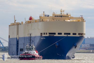
GRAND PAVO
Vehicles Carrier

Current Trip
| Time Travelled | 21 days |
|---|---|
| Remaining Time | --- |
| Distance Travelled | 8198.46 nm |
| Remaining Distance | --- |
| AVG Speed | 15.7 Knopen |
| MAX Speed | 19.4 Knopen |
| AVG Wind | 11.4 knots |
| MAX Wind | 25.9 knots |
| MIN Temp | 12.5°C / 54.5°F |
| MAX Temp | 28.6°C / 83.48°F |
| Diepgang | 8.8 M |
| Positie ontvangen | 5 d geleden |
Current Position
| Lengtegraad | 18.15460° |
|---|---|
| Breedtegraat | -34.25443° |
| Status | Under way using engine |
| Snelheid | 16.6 Knopen |
| Koers | 141.3° |
| Gebied | South Atlantic Ocean |
| Station | T-AIS |
| Positie ontvangen | 5 d geleden |
Information
The current position of GRAND PAVO is in South Atlantic Ocean with coordinates -34.25443° / 18.15460° as reported on 2025-05-30 17:47 by AIS to our vessel tracker app. The vessel's current speed is 16.6 Knopen and is heading at the port of HUANGPU. The estimated time of arrival as calculated by MyShipTracking vessel tracking app is 2025-06-17 10:00 LT
The vessel GRAND PAVO (IMO: 9284776, MMSI: 352879000) is a Vehicles Carrier that was built in 2005 ( 20 Jaar oud ). It's sailing under the flag of [PA] Panama.
In this page you can find informations about the vessels current position, last detected port calls, and current voyage information. If the vessels is not in coverage by AIS you will find the latest position.
The current position of GRAND PAVO is detected by our AIS receivers and we are not responsible for the reliability of the data. The last position was recorded while the vessel was in Coverage by the Ais receivers of our vessel tracking app.
The current draught of GRAND PAVO as reported by AIS is 8.8 meters
Weather
| Temperature | 23.7°C / 74.66°F |
|---|---|
| Wind Speed | 5 knots |
| Direction | 352° N |
| Pressure | 1020.2 hPa |
| Humidity | 71.7 % |
| Cloud Coverage | 1 % |


Featured Company
Last Port Calls
| Port | Arrival | Departure | Time In Port |
|---|---|---|---|
| 2025-05-14 02:32 | 2025-05-14 17:24 | 14 h | |
| 2025-05-11 02:06 | 2025-05-12 23:00 | 1 d | |
| 2025-05-09 03:20 | 2025-05-10 03:20 | 23 h | |
| 2025-05-06 12:21 | 2025-05-07 16:29 | 1 d | |
| 2025-05-05 11:14 | 2025-05-06 07:26 | 20 h | |
| 2025-05-02 19:18 | 2025-05-03 05:19 | 10 h | |
| 2025-04-28 08:00 | 2025-04-28 14:16 | 6 h | |
| 2025-04-23 22:40 | 2025-04-24 16:00 | 17 h | |
| 2025-04-21 14:42 | 2025-04-22 01:08 | 10 h | |
| 2025-04-18 00:53 | 2025-04-18 16:00 | 15 h |
Most Visited Ports (Last year)
| Port | Arrivals | |
|---|---|---|
| 3 | ||
| 3 | ||
| 2 | ||
| 2 | ||
| 2 | ||
| 2 |
Last Trips
| Origin | Departure | Destination | Arrival | Distance | |
|---|---|---|---|---|---|
| 2025-05-13 01:00 | 2025-05-14 03:32 | 466.86 nm | |||
| 2025-05-10 05:20 | 2025-05-11 04:06 | 365.11 nm | |||
| 2025-05-07 18:29 | 2025-05-09 05:20 | 564.86 nm | |||
| 2025-05-06 09:26 | 2025-05-06 14:21 | 52.35 nm | |||
| 2025-05-03 07:19 | 2025-05-05 13:14 | 844.97 nm | |||
| 2025-04-28 14:16 | 2025-05-02 21:18 | 1758.52 nm | |||
| 2025-04-24 16:00 | 2025-04-28 08:00 | 1270.23 nm | |||
| 2025-04-22 01:08 | 2025-04-23 22:40 | 340.56 nm | |||
| 2025-04-18 17:00 | 2025-04-21 14:42 | 1223.44 nm | |||
| 2025-04-12 04:13 | 2025-04-18 01:53 | 2413.76 nm |
Events
| Tijd | Evenement | Details | Positie / Bestemming | Info |
|---|---|---|---|---|
| 2025-05-30 17:51 | Status Changed | Default Under way using engine |
-34.26852 / 18.16773
GBSOU - CNHUA
|
Snelheid: 16.6 kn Koers: 141.3° |
| 2025-05-30 17:47 | Buitenbereik |
-34.25443 / 18.15460
South Atlantic Ocean
GBSOU - CNHUA
|
Snelheid: 16.6 kn Koers: 141.3° |
|
| 2025-05-30 16:44 | ETA Changed | 2025/06/17 10:00 2025/06/20 04:00 |
-34.02374 / 17.93409
GBSOU - CNHUA
|
Snelheid: 17.1 kn Koers: 140.3° |
| 2025-05-30 16:28 | Wijzig zee gebeid | South African part of the South Atlantic Ocean Spanish (Canary Islands) part of the North Atlantic Ocean |
-33.96178 / 17.87326
South Atlantic Ocean
GBSOU - CNHUA
|
Snelheid: 16.8 kn Koers: 142.8° |
| 2025-05-30 16:28 | Status Changed | Under way using engine Default |
-33.96178 / 17.87326
GBSOU - CNHUA
|
Snelheid: 17 kn Koers: 145° |
| 2025-05-30 16:17 | Binnenbereik |
-33.96178 / 17.87326
South Atlantic Ocean
GBSOU - CNHUA
|
Snelheid: 16.8 kn Koers: 142.8° |