
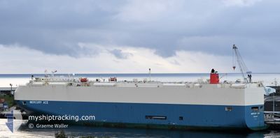
MERCURY ACE
Vehicles Carrier
Current Trip
| Time Travelled | 4 days |
|---|---|
| Remaining Time | 2 days |
| Distance Travelled | 857.73 nm |
| Remaining Distance | 895.95 nm |
| AVG Speed | 11.6 Knopen |
| MAX Speed | 17.7 Knopen |
| AVG Wind | 15.4 knots |
| MAX Wind | 29 knots |
| MIN Temp | 11.6°C / 52.88°F |
| MAX Temp | 18°C / 64.4°F |
| Diepgang | 9.3 M |
| Positie ontvangen | 1 m geleden |
Current Position
| Lengtegraad | -9.74055° |
|---|---|
| Breedtegraat | 38.31459° |
| Status | Under way using engine |
| Snelheid | 16.7 Knopen |
| Koers | 348.9° |
| Gebied | North Atlantic Ocean |
| Station | T-AIS |
| Positie ontvangen | 1 m geleden |
Info
Information
The current position of MERCURY ACE is in North Atlantic Ocean with coordinates 38.31459° / -9.74055° as reported on 2025-03-12 00:44 by AIS to our vessel tracker app. The vessel's current speed is 16.7 Knopen and is heading at the port of PORTBURY. The estimated time of arrival as calculated by MyShipTracking vessel tracking app is 2025-03-14 04:43 LT
The vessel MERCURY ACE (IMO: 9591052, MMSI: 370644000) is a Vehicles Carrier that was built in 2011 ( 14 Jaar oud ). It's sailing under the flag of [PA] Panama.
In this page you can find informations about the vessels current position, last detected port calls, and current voyage information. If the vessels is not in coverage by AIS you will find the latest position.
The current position of MERCURY ACE is detected by our AIS receivers and we are not responsible for the reliability of the data. The last position was recorded while the vessel was in Coverage by the Ais receivers of our vessel tracking app.
The current draught of MERCURY ACE as reported by AIS is 9.3 meters
Weather
| Temperature | 14.3°C / 57.74°F |
|---|---|
| Wind Speed | 9 knots |
| Direction | 326° NW |
| Pressure | 1009.3 hPa |
| Humidity | 72.3 % |
| Cloud Coverage | 39 % |
Featured Company
Last Port Calls
| Port | Arrival | Departure | Time In Port |
|---|---|---|---|
| 2025-03-06 16:57 | 2025-03-07 02:44 | 9 h | |
| 2025-01-29 20:50 | 2025-01-31 03:17 | 1 d | |
| 2025-01-27 21:03 | 2025-01-29 08:10 | 1 d | |
| 2025-01-11 13:01 | 2025-01-11 23:54 | 10 h | |
| 2025-01-09 17:07 | 2025-01-10 01:32 | 8 h | |
| 2025-01-06 00:33 | 2025-01-06 12:40 | 12 h | |
| 2025-01-04 19:18 | 2025-01-05 07:27 | 12 h |
Last Trips
| Origin | Departure | Destination | Arrival | Distance | |
|---|---|---|---|---|---|
| 2025-01-31 12:17 | 2025-03-06 17:57 | 13753.28 nm | |||
| 2025-01-29 17:10 | 2025-01-30 05:50 | 120.94 nm | |||
| 2025-01-11 15:54 | 2025-01-28 06:03 | 6297.66 nm | |||
| 2025-01-09 17:32 | 2025-01-11 05:01 | 420.20 nm | |||
| 2025-01-06 04:40 | 2025-01-09 09:07 | 905.21 nm | |||
| 2025-01-04 23:27 | 2025-01-05 16:33 | 219.56 nm | |||
| 2024-12-20 14:43 | 2025-01-04 11:18 | 5718.94 nm |
Events
| Tijd | Evenement | Details | Positie / Bestemming | Info |
|---|---|---|---|---|
| 2025-03-11 21:30 | Status Changed | Under way using engine Default |
37.42669 / -9.49691
GB BRS
|
Snelheid: 16 kn Koers: 348° |
| 2025-03-11 21:20 | Status Changed | Default Under way using engine |
37.37896 / -9.48407
GB BRS
|
Snelheid: 16.1 kn Koers: 347.8° |
| 2025-03-11 21:13 | Status Changed | Under way using engine Default |
37.34770 / -9.47568
GB BRS
|
Snelheid: 15.6 kn Koers: 348° |
| 2025-03-11 21:12 | Binnenbereik |
37.34770 / -9.47568
North Atlantic Ocean
GB BRS
|
Snelheid: 16.1 kn Koers: 347.8° |
|
| 2025-03-11 17:56 | Status Changed | Default Under way using engine |
36.67384 / -8.93500
GB BRS
|
Snelheid: 16.2 kn Koers: 288.5° |
| 2025-03-11 17:55 | Status Changed | Under way using engine Default |
36.67318 / -8.93241
GB BRS
|
Snelheid: 15.8 kn Koers: 289° |
| 2025-03-11 17:55 | Buitenbereik |
36.67318 / -8.93241
North Atlantic Ocean
GB BRS
|
Snelheid: 16.2 kn Koers: 288.5° |
|
| 2025-03-11 17:36 | Status Changed | Default Under way using engine |
36.64582 / -8.83096
GB BRS
|
Snelheid: 15.9 kn Koers: 288.6° |
| 2025-03-11 17:28 | Status Changed | Under way using engine Default |
36.63453 / -8.78913
GB BRS
|
Snelheid: 16.5 kn Koers: 290° |
| 2025-03-11 17:20 | Status Changed | Default Under way using engine |
36.62301 / -8.74771
GB BRS
|
Snelheid: 15.5 kn Koers: 289.9° |