
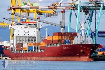
MSC ACE II
Container Ship
Current Trip
| Time Travelled | 1 day |
|---|---|
| Remaining Time | 1 day |
| Distance Travelled | 351.59 nm |
| Remaining Distance | 377.44 nm |
| AVG Speed | 14.1 Knopen |
| MAX Speed | 16.3 Knopen |
| AVG Wind | 15.3 knots |
| MAX Wind | 24 knots |
| MIN Temp | 17.7°C / 63.86°F |
| MAX Temp | 20.1°C / 68.18°F |
| Diepgang | 10.4 M |
| Positie ontvangen | 22 h, 29 m geleden |
Current Position
| Lengtegraad | 18.17248° |
|---|---|
| Breedtegraat | -33.67889° |
| Status | Under way using engine |
| Snelheid | 13.8 Knopen |
| Koers | 313.3° |
| Gebied | South Atlantic Ocean |
| Station | T-AIS |
| Positie ontvangen | 22 h, 29 m geleden |
Info
Information
The current position of MSC ACE II is in South Atlantic Ocean with coordinates -33.67889° / 18.17248° as reported on 2025-03-10 08:58 by AIS to our vessel tracker app. The vessel's current speed is 13.8 Knopen and is heading at the port of WALVIS BAY. The estimated time of arrival as calculated by MyShipTracking vessel tracking app is 2025-03-12 09:48 LT
The vessel MSC ACE II (IMO: 9309162, MMSI: 636019697) is a Container Ship that was built in 2005 ( 20 Jaar oud ). It's sailing under the flag of [LR] Liberia.
In this page you can find informations about the vessels current position, last detected port calls, and current voyage information. If the vessels is not in coverage by AIS you will find the latest position.
The current position of MSC ACE II is detected by our AIS receivers and we are not responsible for the reliability of the data. The last position was recorded while the vessel was in Coverage by the Ais receivers of our vessel tracking app.
The current draught of MSC ACE II as reported by AIS is 10.4 meters
Weather
| Temperature | 18.1°C / 64.58°F |
|---|---|
| Wind Speed | 20 knots |
| Direction | 155° SSE |
| Pressure | 1016.6 hPa |
| Humidity | 87.1 % |
| Cloud Coverage | --- |
Featured Company
Last Port Calls
| Port | Arrival | Departure | Time In Port |
|---|---|---|---|
| 2025-03-05 10:47 | 2025-03-10 07:28 | 4 d | |
| 2025-02-25 18:52 | 2025-02-27 06:20 | 1 d | |
| 2025-02-20 10:33 | 2025-02-21 20:18 | 1 d | |
| 2025-02-07 14:20 | 2025-02-09 19:12 | 2 d | |
| 2025-01-29 22:57 | 2025-02-03 16:49 | 4 d | |
| 2025-01-27 10:33 | 2025-01-28 23:57 | 1 d | |
| 2025-01-24 12:37 | 2025-01-26 23:53 | 2 d | |
| 2025-01-22 20:41 | 2025-01-24 00:57 | 1 d | |
| 2025-01-18 13:36 | 2025-01-19 07:55 | 18 h | |
| 2025-01-11 19:08 | 2025-01-12 07:12 | 12 h |
Most Visited Ports (Last year)
| Port | Arrivals | |
|---|---|---|
| 19 | ||
| 8 | ||
| 6 | ||
| 6 | ||
| 3 | ||
| 2 |
Last Trips
| Origin | Departure | Destination | Arrival | Distance | |
|---|---|---|---|---|---|
| 2025-02-27 08:20 | 2025-03-05 12:47 | 587.26 nm | |||
| 2025-02-21 22:18 | 2025-02-25 20:52 | 746.98 nm | |||
| 2025-02-09 20:12 | 2025-02-20 12:33 | 2672.41 nm | |||
| 2025-02-03 17:49 | 2025-02-07 15:20 | 1366.57 nm | |||
| 2025-01-28 23:57 | 2025-01-29 23:57 | 152.55 nm | |||
| 2025-01-27 00:53 | 2025-01-27 10:33 | 147.99 nm | |||
| 2025-01-24 00:57 | 2025-01-24 13:37 | 155.57 nm | |||
| 2025-01-19 08:55 | 2025-01-22 20:41 | 1194.85 nm | |||
| 2025-01-12 09:12 | 2025-01-18 14:36 | 932.62 nm | |||
| 2025-01-09 15:24 | 2025-01-11 21:08 | 732.42 nm |
Events
| Tijd | Evenement | Details | Positie / Bestemming | Info |
|---|---|---|---|---|
| 2025-03-10 09:05 | Status Changed | Default Under way using engine |
-33.66318 / 18.15038
CAPETOWN>WALVISBAY
|
Snelheid: 13.8 kn Koers: 313.3° |
| 2025-03-10 08:58 | Buitenbereik |
-33.67889 / 18.17248
South Atlantic Ocean
CAPETOWN>WALVISBAY
|
Snelheid: 13.8 kn Koers: 313.3° |
|
| 2025-03-10 08:23 | ETA Changed | 2025/03/12 12:00 2025/03/12 13:00 |
-33.78342 / 18.27957
CAPETOWN>WALVISBAY
|
Snelheid: 13.9 kn Koers: 321° |
| 2025-03-10 08:11 | Draught Changed | 10.4 10.6 |
-33.81886 / 18.31722
CAPETOWN>WALVISBAY
|
Snelheid: 13.6 kn Koers: 312.8° |
| 2025-03-10 08:05 | ETA Changed | 2025/03/12 13:00 2025/03/12 12:00 |
-33.83608 / 18.33711
CAPETOWN>WALVISBAY
|
Snelheid: 13.6 kn Koers: 315.9° |
| 2025-03-10 07:28 | Vertrekhaven |
|
-33.89746 / 18.43725
CAPETOWN>WALVISBAY
|
Snelheid: 6.9 kn Koers: 345° |
| 2025-03-10 07:18 | Start beweging |
-33.91129 / 18.43269
[ZA] CAPE TOWN
|
Snelheid: 3.1 kn Koers: 22° |
|
| 2025-03-10 07:00 | Status Changed | Under way using engine Moored |
-33.91278 / 18.42992
[ZA] CAPE TOWN
|
Snelheid: Koers: 313° |
| 2025-03-10 03:03 | Destination Changed | CAPETOWN>WALVISBAY COEGA>CAPETOWN |
-33.91278 / 18.42988
[ZA] CAPE TOWN
|
Snelheid: Koers: 312° |
| 2025-03-10 03:03 | ETA Changed | 2025/03/12 12:00 2026/02/28 15:00 |
-33.91278 / 18.42988
[ZA] CAPE TOWN
|
Snelheid: Koers: 312° |