
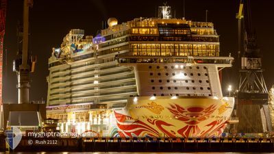
NORWEGIAN JOY
Passenger
Current Trip
GSC, BS
| Time Travelled | 1 day |
|---|---|
| Remaining Time | --- |
| Distance Travelled | 453.33 nm |
| Remaining Distance | --- |
| AVG Speed | 17.3 Knopen |
| MAX Speed | 21 Knopen |
| AVG Wind | 14.5 knots |
| MAX Wind | 21.3 knots |
| MIN Temp | 23°C / 73.4°F |
| MAX Temp | 26.9°C / 80.42°F |
| Diepgang | 8.7 M |
| Positie ontvangen | 23 h, 55 m geleden |
Current Position
| Lengtegraad | -86.76947° |
|---|---|
| Breedtegraat | 20.81744° |
| Status | Under way using engine |
| Snelheid | 20.7 Knopen |
| Koers | 36.3° |
| Gebied | Caribbean Sea |
| Station | T-AIS |
| Positie ontvangen | 23 h, 55 m geleden |
Info
Information
The current position of NORWEGIAN JOY is in Caribbean Sea with coordinates 20.81744° / -86.76947° as reported on 2025-12-14 23:22 by AIS to our vessel tracker app. The vessel's current speed is 20.7 Knopen
The vessel NORWEGIAN JOY (IMO: 9703796, MMSI: 311000599) is a Passenger It's sailing under the flag of [BS] Bahamas.
In this page you can find informations about the vessels current position, last detected port calls, and current voyage information. If the vessels is not in coverage by AIS you will find the latest position.
The current position of NORWEGIAN JOY is detected by our AIS receivers and we are not responsible for the reliability of the data. The last position was recorded while the vessel was in Coverage by the Ais receivers of our vessel tracking app.
The current draught of NORWEGIAN JOY as reported by AIS is 8.7 meters
Weather
| Temperature | 23.6°C / 74.48°F |
|---|---|
| Wind Speed | 21 knots |
| Direction | 57° ENE |
| Pressure | 1018.8 hPa |
| Humidity | 73.1 % |
| Cloud Coverage | 94 % |
Featured Company
Last Port Calls
| Port | Arrival | Departure | Time In Port |
|---|---|---|---|
| 2025-12-14 07:18 | 2025-12-14 16:59 | 9 h | |
| 2025-12-12 04:09 | 2025-12-12 16:08 | 11 h | |
| 2025-12-09 06:02 | 2025-12-09 15:08 | 9 h | |
| 2025-12-08 08:50 | 2025-12-08 18:33 | 9 h | |
| 2025-12-07 08:47 | 2025-12-07 17:59 | 9 h | |
| 2025-12-05 04:45 | 2025-12-05 16:50 | 12 h | |
| 2025-12-04 06:20 | 2025-12-04 16:30 | 10 h | |
| 2025-12-02 06:04 | 2025-12-02 16:21 | 10 h | |
| 2025-12-01 05:35 | 2025-12-01 16:24 | 10 h | |
| 2025-11-29 04:13 | 2025-11-29 16:50 | 12 h |
Last Trips
| Origin | Departure | Destination | Arrival | Distance | |
|---|---|---|---|---|---|
| 2025-12-12 16:08 | 2025-12-14 07:18 | 701.16 nm | |||
| 2025-12-09 15:08 | 2025-12-12 04:09 | 1080.65 nm | |||
| 2025-12-08 18:33 | 2025-12-09 06:02 | 77.29 nm | |||
| 2025-12-07 17:59 | 2025-12-08 08:50 | 272.07 nm | |||
| 2025-12-05 16:50 | 2025-12-07 08:47 | 769.78 nm | |||
| 2025-12-04 16:30 | 2025-12-05 04:45 | 273.57 nm | |||
| 2025-12-02 16:21 | 2025-12-04 06:20 | 325.92 nm | |||
| 2025-12-01 16:24 | 2025-12-02 06:04 | 273.59 nm | |||
| 2025-11-29 16:50 | 2025-12-01 05:35 | 371.69 nm | |||
| 2025-11-26 14:03 | 2025-11-29 04:13 | 1097.27 nm |
Events
| Tijd | Evenement | Details | Positie / Bestemming | Info |
|---|---|---|---|---|
| 2025-12-14 23:56 | Status Changed | Default Under way using engine |
20.97215 / -86.65060
GSC, BS
|
Snelheid: 20.7 kn Koers: 36.3° |
| 2025-12-14 23:22 | Buitenbereik |
20.81744 / -86.76947
Caribbean Sea
GSC, BS
|
Snelheid: 20.7 kn Koers: 36.3° |
|
| 2025-12-14 21:59 | Vertrekhaven |
|
20.50968 / -86.96144
GSC, BS
|
Snelheid: 3.8 kn Koers: 250° |
| 2025-12-14 21:57 | Start beweging |
20.50947 / -86.95955
[MX] COZUMEL
|
Snelheid: 3.5 kn Koers: 222° |
|
| 2025-12-14 21:54 | Status Changed | Under way using engine Moored |
20.50931 / -86.95743
[MX] COZUMEL
|
Snelheid: Koers: 199° |
| 2025-12-14 13:15 | Destination Changed | GSC, BS GSC |
20.50930 / -86.95740
[MX] COZUMEL
|
Snelheid: Koers: 199° |
| 2025-12-14 13:15 | ETA Changed | 2025/12/16 12:00 2025/12/14 12:00 |
20.50930 / -86.95740
[MX] COZUMEL
|
Snelheid: Koers: 199° |
| 2025-12-14 13:06 | Destination Changed | GSC COZUMEL, MEXICO |
20.50929 / -86.95740
[MX] COZUMEL
|
Snelheid: Koers: 199° |
| 2025-12-14 13:05 | Status Changed | Moored Under way using engine |
20.50929 / -86.95740
[MX] COZUMEL
|
Snelheid: Koers: 199° |
| 2025-12-14 12:32 | Stop beweging |
20.50946 / -86.95749
[MX] COZUMEL
|
Snelheid: 0.2 kn Koers: 200° |