
AH EVER
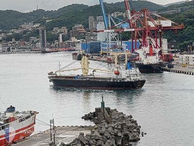
General Cargo
Current Trip
| Time Travelled | 2 days |
|---|---|
| Remaining Time | --- |
| Distance Travelled | 358.97 морская миля |
| Remaining Distance | --- |
| AVG Speed | 11.8 Узлы |
| MAX Speed | 13.1 Узлы |
| AVG Wind | 8.2 knots |
| MAX Wind | 15.5 knots |
| MIN Temp | -0.8°C / 30.56°F |
| MAX Temp | 10.8°C / 51.44°F |
| Осадка | 8.3 м |
| Позиция Получена | 11 d тому назад |
Current Position
| Долгота | 120.08593° |
|---|---|
| Широта | 22.71313° |
| Статус | Under way using engine |
| Скорость | 10.4 Узлы |
| Курс | 304.5° |
| Район | South China Sea |
| Станция | T-AIS |
| Позиция Получена | 11 d тому назад |
Info
Information
The current position of AH EVER is in South China Sea with coordinates 22.71313° / 120.08593° as reported on 2025-12-24 05:41 by AIS to our vessel tracker app. The vessel's current speed is 10.4 Узлы and is heading at the port of ZHAPU. The estimated time of arrival as calculated by MyShipTracking vessel tracking app is 2025-12-27 00:00 LT
The vessel AH EVER (IMO: 9201712, MMSI: 357587000) is a General Cargo that was built in 1999 ( 27 лет ). It's sailing under the flag of [PA] Panama.
In this page you can find informations about the vessels current position, last detected port calls, and current voyage information. If the vessels is not in coverage by AIS you will find the latest position.
The current position of AH EVER is detected by our AIS receivers and we are not responsible for the reliability of the data. The last position was recorded while the vessel was in Coverage by the Ais receivers of our vessel tracking app.
The current draught of AH EVER as reported by AIS is 8.3 meters
Weather
| Temperature | 8.2°C / 46.76°F |
|---|---|
| Wind Speed | 11 knots |
| Direction | 302° WNW |
| Pressure | 1024.4 hPa |
| Humidity | 79.2 % |
| Cloud Coverage | 100 % |
Featured Company
Last Port Calls
| Port | Arrival | Departure | Time In Port |
|---|---|---|---|
| 2025-12-31 12:28 | 2026-01-02 13:32 | 2 d | |
| 2025-12-28 18:36 | 2025-12-29 12:04 | 17 h | |
| 2025-12-24 05:38 | 2025-12-24 12:38 | 6 h | |
| 2025-11-25 11:53 | 2025-11-27 07:00 | 1 d |
Last Trips
| Origin | Departure | Destination | Arrival | Distance | |
|---|---|---|---|---|---|
| 2025-12-29 12:04 | 2025-12-31 12:28 | 469.96 морская миля | |||
| 2025-12-24 12:38 | 2025-12-28 18:36 | 659.04 морская миля | |||
| 2025-11-27 07:00 | 2025-12-24 05:38 | 3629.87 морская миля | |||
| 2025-10-17 14:43 | 2025-11-25 11:53 | 5183.79 морская миля |
Events
| Время | Событие | Детали | Позиция / Направление | Информация |
|---|---|---|---|---|
| 2026-01-03 11:25 | Окончание движения | 21.31 nm, North East of SHENGSI |
31.05392 / 122.61806
ZHAPU
|
Скорость: 0.2 kn Курс: 24° |
| 2026-01-02 05:32 | ПОРТ ОТПРАВЛЕНИЯ |
|
34.74915 / 119.53838
ZHAPU
|
Скорость: 11.2 kn Курс: 58° |
| 2026-01-02 05:01 | Начало движения |
34.74189 / 119.45122
[CN] LIANYUNGANG
|
Скорость: 3.2 kn Курс: 64° |
|
| 2025-12-31 04:28 | Окончание движения |
34.73902 / 119.44762
[CN] LIANYUNGANG
|
Скорость: 0.1 kn Курс: 212° |
|
| 2025-12-31 04:28 | Порт |
|
34.73902 / 119.44762
[CN] LIANYUNGANG
|
Скорость: 3.5 kn Курс: 214° |
| 2025-12-31 02:35 | Начало движения | 12.21 nm, North East of LIANYUNGANG |
34.84042 / 119.70440
ZHAPU
|
Скорость: 5.5 kn Курс: 229° |
| 2025-12-30 22:08 | Окончание движения | 12.46 nm, North East of LIANYUNGANG |
34.84410 / 119.70775
ZHAPU
|
Скорость: 0.3 kn Курс: 327° |
| 2025-12-29 04:09 | Начало движения | 0.69 nm, South West of ZHAPU |
30.57670 / 121.08232
ZHAPU
|
Скорость: 6.6 kn Курс: 141° |
| 2025-12-29 04:04 | ПОРТ ОТПРАВЛЕНИЯ |
|
30.57670 / 121.08232
ZHAPU
|
Скорость: Курс: 247° |
| 2025-12-28 10:45 | Окончание движения |
30.58223 / 121.07507
[CN] ZHAPU
|
Скорость: 0.1 kn Курс: 260° |