
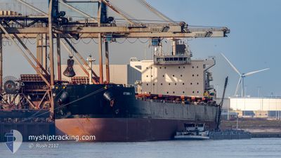
KYTHIRA I
Bulk Carrier
Current Trip
| Time Travelled | 27 days |
|---|---|
| Remaining Time | 1 day |
| Distance Travelled | 7103.20 морская миля |
| Remaining Distance | 521.77 морская миля |
| AVG Speed | 10.7 Узлы |
| MAX Speed | 14.7 Узлы |
| AVG Wind | 14.5 knots |
| MAX Wind | 29.7 knots |
| MIN Temp | 11.4°C / 52.52°F |
| MAX Temp | 35.5°C / 95.9°F |
| Осадка | 10.1 м |
| Позиция Получена | 54 m тому назад |
Current Position
| Долгота | 26.27346° |
|---|---|
| Широта | 34.50878° |
| Статус | Under way using engine |
| Скорость | 11.6 Узлы |
| Курс | 78° |
| Район | Mediterranean Sea - Eastern Basin |
| Станция | T-AIS |
| Позиция Получена | 54 m тому назад |
Info
Information
The current position of KYTHIRA I is in Mediterranean Sea - Eastern Basin with coordinates 34.50878° / 26.27346° as reported on 2025-02-09 02:20 by AIS to our vessel tracker app. The vessel's current speed is 11.6 Узлы and is heading at the port of ISKENDERUN. The estimated time of arrival as calculated by MyShipTracking vessel tracking app is 2025-02-10 22:21 LT
The vessel KYTHIRA I (IMO: 9590046, MMSI: 636017090) is a Bulk Carrier that was built in 2011 ( 14 лет ). It's sailing under the flag of [LR] Liberia.
In this page you can find informations about the vessels current position, last detected port calls, and current voyage information. If the vessels is not in coverage by AIS you will find the latest position.
The current position of KYTHIRA I is detected by our AIS receivers and we are not responsible for the reliability of the data. The last position was recorded while the vessel was in Coverage by the Ais receivers of our vessel tracking app.
The current draught of KYTHIRA I as reported by AIS is 10.1 meters
Weather
| Temperature | 12.2°C / 53.96°F |
|---|---|
| Wind Speed | 27 knots |
| Direction | 345° NNW |
| Pressure | 1021.4 hPa |
| Humidity | 65.9 % |
| Cloud Coverage | 40 % |
Featured Company
Last Port Calls
| Port | Arrival | Departure | Time In Port |
|---|---|---|---|
| 2025-01-09 13:08 | 2025-01-12 06:18 | 2 d | |
| 2025-01-03 15:02 | 2025-01-08 21:46 | 5 d | |
| 2024-12-07 16:02 | 2024-12-08 20:31 | 1 d |
Most Visited Ports (Last year)
| Port | Arrivals | |
|---|---|---|
| 2 | ||
| 2 | ||
| 1 | ||
| 1 | ||
| 1 | ||
| 1 |
Last Trips
| Origin | Departure | Destination | Arrival | Distance | |
|---|---|---|---|---|---|
| 2025-01-08 18:46 | 2025-01-09 10:08 | 153.24 морская миля | |||
| 2024-12-08 15:31 | 2025-01-03 12:02 | 6174.52 морская миля | |||
| 2024-11-08 06:38 | 2024-12-07 11:02 | 5273.43 морская миля |
Events
| Время | Событие | Детали | Позиция / Направление | Информация |
|---|---|---|---|---|
| 2025-02-09 02:45 | Статус изменился | Default Under way using engine |
34.52578 / 26.37018
TR ISK
|
Скорость: 11.6 kn Курс: 78° |
| 2025-02-09 01:12 | Статус изменился | Under way using engine Default |
34.48679 / 26.01110
TR ISK
|
Скорость: 11.4 kn Курс: 93° |
| 2025-02-09 01:12 | В покрытии |
34.48679 / 26.01110
Mediterranean Sea - Eastern Basin
TR ISK
|
Скорость: 11.8 kn Курс: 89.4° |
|
| 2025-02-09 00:14 | Статус изменился | Default Under way using engine |
34.49088 / 25.78248
TR ISK
|
Скорость: 11.2 kn Курс: 91.2° |
| 2025-02-09 00:06 | Вне покрытия |
34.49170 / 25.75278
Mediterranean Sea - Eastern Basin
TR ISK
|
Скорость: 11.2 kn Курс: 91.2° |
|
| 2025-02-08 23:08 | Статус изменился | Under way using engine Default |
34.49153 / 25.50964
TR ISK
|
Скорость: 11.9 kn Курс: 90° |
| 2025-02-08 23:08 | В покрытии |
34.49153 / 25.50964
Mediterranean Sea - Eastern Basin
TR ISK
|
Скорость: 13.6 kn Курс: 91.5° |
|
| 2025-02-08 22:11 | Статус изменился | Default Under way using engine |
34.48968 / 25.25997
TR ISK
|
Скорость: 12.2 kn Курс: 91.2° |
| 2025-02-08 21:58 | Вне покрытия |
34.48969 / 25.20586
Mediterranean Sea - Eastern Basin
TR ISK
|
Скорость: 12.2 kn Курс: 91.2° |
|
| 2025-02-08 21:49 | Статус изменился | Under way using engine Default |
34.49013 / 25.17236
TR ISK
|
Скорость: 11.6 kn Курс: 91° |