

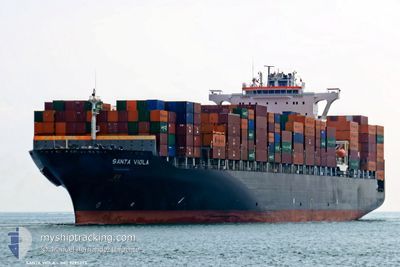
SANTA VIOLA
Container Ship

Current Trip
| Time Travelled | 21 days |
|---|---|
| Remaining Time | --- |
| Distance Travelled | 8621.92 nm |
| Remaining Distance | --- |
| AVG Speed | 20.1 Knop |
| MAX Speed | 23.2 Knop |
| AVG Wind | 12.9 knots |
| MAX Wind | 25 knots |
| MIN Temp | 15.3°C / 59.54°F |
| MAX Temp | 28.5°C / 83.3°F |
| Djupgående | 10.5 m |
| Position mottagen | 6 d sen |
Current Position
| Longitud | 18.26587° |
|---|---|
| Latitude | -34.62257° |
| Status | Under way using engine |
| Fart | 19.9 Knop |
| Kurs | 108.3° |
| Område | South Atlantic Ocean |
| Station | T-AIS |
| Position mottagen | 6 d sen |
Information
The current position of SANTA VIOLA is in South Atlantic Ocean with coordinates -34.62257° / 18.26587° as reported on 2025-05-28 01:55 by AIS to our vessel tracker app. The vessel's current speed is 19.9 Knop and is heading at the port of TEMA.
The vessel SANTA VIOLA (IMO: 9295373, MMSI: 256570000) is a Container Ship that was built in 2005 ( 20 År gammal ). It's sailing under the flag of [MT] Malta.
In this page you can find informations about the vessels current position, last detected port calls, and current voyage information. If the vessels is not in coverage by AIS you will find the latest position.
The current position of SANTA VIOLA is detected by our AIS receivers and we are not responsible for the reliability of the data. The last position was recorded while the vessel was in Coverage by the Ais receivers of our vessel tracking app.
The current draught of SANTA VIOLA as reported by AIS is 10.5 meters
Weather
| Temperature | 23.3°C / 73.94°F |
|---|---|
| Wind Speed | 20 knots |
| Direction | 105° ESE |
| Pressure | 1021.9 hPa |
| Humidity | 69.2 % |
| Cloud Coverage | 19 % |


Featured Company
Most Visited Ports (Last year)
| Port | Arrivals | |
|---|---|---|
| 7 | ||
| 7 | ||
| 7 | ||
| 6 | ||
| 6 | ||
| 6 |
Last Trips
| Origin | Departure | Destination | Arrival | Distance | |
|---|---|---|---|---|---|
| 2025-05-02 19:48 | 2025-05-10 20:10 | 1133.67 nm | |||
| 2025-04-28 14:27 | 2025-05-01 15:32 | 395.34 nm | |||
| 2025-04-25 15:22 | 2025-04-26 12:11 | 172.79 nm | |||
| 2025-04-06 20:23 | 2025-04-24 20:45 | 5356.79 nm | |||
| 2025-03-30 13:48 | 2025-04-04 11:42 | 510.66 nm |
Events
| Tid | Event | Detaljer | Position / Dest | Information |
|---|---|---|---|---|
| 2025-05-28 01:59 | Status ändrad | Default Under way using engine |
-34.63059 / 18.29657
GHTEM
|
Fart: 19.9 kn Kurs: 108.3° |
| 2025-05-28 01:55 | UTANFÖR täckningsområde |
-34.62257 / 18.26587
South Atlantic Ocean
|
Fart: 19.9 kn Kurs: 108.3° |
|
| 2025-05-28 01:43 | Status ändrad | Under way using engine Default |
-34.60228 / 18.18995
GHTEM
|
Fart: 19.8 kn Kurs: 114° |
| 2025-05-28 01:28 | Status ändrad | Default Under way using engine |
-34.57746 / 18.09547
GHTEM
|
Fart: 19.5 kn Kurs: 106.4° |
| 2025-05-28 01:23 | Status ändrad | Under way using engine Default |
-34.56894 / 18.06261
GHTEM
|
Fart: 19.8 kn Kurs: 102° |
| 2025-05-28 00:41 | Status ändrad | Default Under way using engine |
-34.44735 / 17.83620
GHTEM
|
Fart: 19.2 kn Kurs: 138.1° |
| 2025-05-28 00:31 | Byter havsområde | South African part of the South Atlantic Ocean Senegalese part of the North Atlantic Ocean |
-34.40763 / 17.79484
South Atlantic Ocean
|
Fart: 19.2 kn Kurs: 137.9° |
| 2025-05-28 00:31 | Status ändrad | Under way using engine Default |
-34.40763 / 17.79484
GHTEM
|
Fart: 19.6 kn Kurs: 143° |
| 2025-05-28 00:20 | I täckningsområde |
-34.40763 / 17.79484
South Atlantic Ocean
|
Fart: 19.2 kn Kurs: 137.9° |