
TUHI-RAPA
Passenger
Current Trip
| Time Travelled | 52 mins |
|---|---|
| Remaining Time | 5 h, 25 mins |
| Distance Travelled | 5.61 nm |
| Remaining Distance | --- |
| AVG Speed | 23.8 Knop |
| MAX Speed | 23.8 Knop |
| AVG Wind | 6.1 knots |
| MAX Wind | 8 knots |
| MIN Temp | 19.1°C / 66.38°F |
| MAX Temp | 21°C / 69.8°F |
| Djupgående | --- |
| Position mottagen | 2 m sen |
Current Position
| Longitud | 174.88636° |
|---|---|
| Latitude | -36.60708° |
| Status | Default |
| Fart | 0.3 Knop |
| Kurs | --- |
| Område | South Pacific Ocean |
| Station | T-AIS |
| Position mottagen | 2 m sen |
Info
Information
The current position of TUHI-RAPA is in South Pacific Ocean with coordinates -36.60708° / 174.88636° as reported on 2025-02-11 21:53 by AIS to our vessel tracker app. The vessel's current speed is 0.3 Knop and is heading at the port of CHELSEA. The estimated time of arrival as calculated by MyShipTracking vessel tracking app is 2025-02-12 16:20 LT
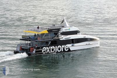
The vessel TUHI-RAPA (MMSI: 512468000) is a Passenger It's sailing under the flag of [NZ] New Zealand.
In this page you can find informations about the vessels current position, last detected port calls, and current voyage information. If the vessels is not in coverage by AIS you will find the latest position.
The current position of TUHI-RAPA is detected by our AIS receivers and we are not responsible for the reliability of the data. The last position was recorded while the vessel was in Coverage by the Ais receivers of our vessel tracking app.
Weather
| Temperature | 19°C / 66.2°F |
|---|---|
| Wind Speed | 8 knots |
| Direction | 95° E |
| Pressure | 1021.5 hPa |
| Humidity | 68.1 % |
| Cloud Coverage | --- |
Featured Company
Last Port Calls
| Port | Arrival | Departure | Time In Port |
|---|---|---|---|
| 2025-02-12 09:53 | 2025-02-12 10:03 | 10 m | |
| 2025-02-12 08:09 | 2025-02-12 09:13 | 1 h | |
| 2025-02-12 07:42 | 2025-02-12 08:02 | 20 m | |
| 2025-02-12 07:28 | 2025-02-12 07:38 | 10 m | |
| 2025-02-12 06:58 | 2025-02-12 07:22 | 24 m | |
| 2025-02-12 06:40 | 2025-02-12 06:53 | 13 m | |
| 2025-02-12 06:22 | 2025-02-12 06:36 | 13 m | |
| 2025-02-11 21:01 | 2025-02-12 06:18 | 9 h | |
| 2025-02-11 20:18 | 2025-02-11 20:53 | 34 m | |
| 2025-02-11 20:01 | 2025-02-11 20:11 | 10 m |
Last Trips
| Origin | Departure | Destination | Arrival | Distance | |
|---|---|---|---|---|---|
| 2025-02-12 09:13 | 2025-02-12 09:53 | 14.75 nm | |||
| 2025-02-12 08:02 | 2025-02-12 08:09 | 1.32 nm | |||
| 2025-02-12 07:38 | 2025-02-12 07:42 | 1.83 nm | |||
| 2025-02-12 07:22 | 2025-02-12 07:28 | 1.54 nm | |||
| 2025-02-12 06:53 | 2025-02-12 06:58 | 2.09 nm | |||
| 2025-02-12 06:36 | 2025-02-12 06:40 | 1.42 nm | |||
| 2025-02-12 06:18 | 2025-02-12 06:22 | 1.81 nm | |||
| 2025-02-11 20:53 | 2025-02-11 21:01 | 0.54 nm | |||
| 2025-02-11 20:11 | 2025-02-11 20:18 | 0.77 nm | |||
| 2025-02-11 19:56 | 2025-02-11 20:01 | 1.17 nm |
Events
| Tid | Event | Detaljer | Position / Dest | Information |
|---|---|---|---|---|
| 2025-02-11 21:23 | STOPPAR förflyttning | 4.89 nm, East of GULF HARBOUR |
-36.60578 / 174.88802
|
Fart: Kurs: -1° |
| 2025-02-11 21:03 | AVGÅTT HAMN |
|
-36.62873 / 174.78705
|
Fart: 7.3 kn Kurs: 215.7° |
| 2025-02-11 21:03 | STARTAR förflyttning |
-36.62608 / 174.78678
[NZ] GULF HARBOUR
|
Fart: 7.3 kn Kurs: 215.7° |
|
| 2025-02-11 20:58 | STOPPAR förflyttning |
-36.62423 / 174.78819
[NZ] GULF HARBOUR
|
Fart: 0.1 kn Kurs: 511° |
|
| 2025-02-11 20:53 | ANLÄNDER HAMN |
|
-36.62642 / 174.78674
[NZ] GULF HARBOUR
|
Fart: 17.8 kn Kurs: 336.2° |
| 2025-02-11 20:13 | AVGÅTT HAMN |
|
-36.83768 / 174.78132
|
Fart: 11 kn Kurs: 91.8° |
| 2025-02-11 20:05 | STARTAR förflyttning |
-36.84246 / 174.76022
[NZ] AUCKLAND
|
Fart: 5.5 kn Kurs: 261.1° |
|
| 2025-02-11 19:26 | STOPPAR förflyttning |
-36.84250 / 174.76302
[NZ] AUCKLAND
|
Fart: 0.2 kn Kurs: 511° |
|
| 2025-02-11 19:09 | ANLÄNDER HAMN |
|
-36.84163 / 174.76686
[NZ] AUCKLAND
|
Fart: 6.4 kn Kurs: 153.9° |
| 2025-02-11 19:02 | STARTAR förflyttning | 0.59 nm, North West of WESTHAVEN |
-36.82881 / 174.74818
|
Fart: 20.2 kn Kurs: 95.6° |