
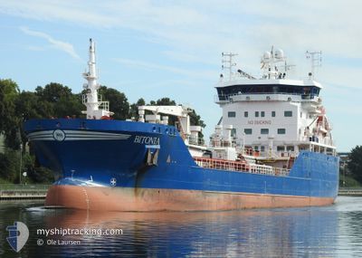
BITONIA
Asphalt/Bitumen Tanker
Current Trip
| Trip Time | 2 days |
|---|---|
| Trip Distance | 557.50 nm |
| AVG Speed | 10.8 Knots |
| MAX Speed | 13.6 Knots |
| Draught | 6.6 m |
| AVG Wind | 10.5 knots |
| MAX Wind | 18 knots |
| MIN Temp | 0.1°C / 32.18°F |
| MAX Temp | 6.8°C / 44.24°F |
| Position Received | 11 h, 1 m ago |
Current Position
| Longitude | -2.94420° |
|---|---|
| Latitude | 56.46360° |
| Status | Under way using engine |
| Speed | |
| Course | 67° |
| Area | North Sea |
| Station | T-AIS |
| Position Received | 11 h, 1 m ago |
Info
Information
The current position of BITONIA is in North Sea with coordinates 56.46360° / -2.94420° as reported on 2025-02-15 04:14 by AIS to our vessel tracker app. The vessel's current speed is 0 Knots and is currently inside the port of DUNDEE.
The vessel BITONIA (IMO: 9503902, MMSI: 246354000) is a Asphalt/Bitumen Tanker that was built in 2012 ( 13 years old ). It's sailing under the flag of [NL] Netherlands.
In this page you can find informations about the vessels current position, last detected port calls, and current voyage information. If the vessels is not in coverage by AIS you will find the latest position.
The current position of BITONIA is detected by our AIS receivers and we are not responsible for the reliability of the data. The last position was recorded while the vessel was in Coverage by the Ais receivers of our vessel tracking app.
The current draught of BITONIA as reported by AIS is 6.6 meters
Weather
| Temperature | 2.4°C / 36.32°F |
|---|---|
| Wind Speed | 7 knots |
| Direction | 59° ENE |
| Pressure | 1020.8 hPa |
| Humidity | 97.9 % |
| Cloud Coverage | 100 % |
Featured Company
Last Port Calls
| Port | Arrival | Departure | Time In Port |
|---|---|---|---|
| 2025-02-15 03:58 | |||
| 2025-02-12 01:15 | 2025-02-12 23:38 | 22 h | |
| 2025-02-04 03:23 | 2025-02-05 03:06 | 23 h | |
| 2025-02-03 14:20 | 2025-02-04 00:22 | 10 h | |
| 2025-01-27 01:11 | 2025-01-27 13:25 | 12 h | |
| 2025-01-23 10:53 | 2025-01-23 18:56 | 8 h | |
| 2025-01-22 12:22 | 2025-01-22 23:34 | 11 h | |
| 2025-01-12 12:37 | 2025-01-13 05:00 | 16 h | |
| 2025-01-09 07:38 | 2025-01-10 09:23 | 1 d | |
| 2025-01-07 16:36 | 2025-01-09 03:57 | 1 d |
Most Visited Ports (Last year)
| Port | Arrivals | |
|---|---|---|
| 31 | ||
| 11 | ||
| 8 | ||
| 7 | ||
| 7 | ||
| 6 |
Last Trips
| Origin | Departure | Destination | Arrival | Distance | |
|---|---|---|---|---|---|
| 2025-02-12 23:38 | 2025-02-15 03:58 | 557.50 nm | |||
| 2025-02-05 03:06 | 2025-02-12 01:15 | 572.69 nm | |||
| 2025-01-27 13:25 | 2025-02-04 03:23 | 1638.23 nm | |||
| 2025-01-27 13:25 | 2025-02-03 14:20 | 1610.53 nm | |||
| 2025-01-23 18:56 | 2025-01-27 01:11 | 674.47 nm | |||
| 2025-01-22 23:34 | 2025-01-23 10:53 | 137.06 nm | |||
| 2025-01-13 05:00 | 2025-01-22 12:22 | 1351.21 nm | |||
| 2025-01-10 09:23 | 2025-01-12 12:37 | 554.58 nm | |||
| 2025-01-09 03:57 | 2025-01-09 07:38 | 37.80 nm | |||
| 2024-12-20 13:28 | 2025-01-07 16:36 | 623.11 nm |
Events
| Time | Event | Details | Position / Dest | Info |
|---|---|---|---|---|
| 2025-02-15 04:20 | Status Changed | Default Under way using engine |
56.46363 / -2.94423
[GB] DUNDEE
|
Speed: Course: 67° |
| 2025-02-15 04:14 | OUT of Coverage |
56.46360 / -2.94420
North Sea
[GB] DUNDEE
|
Speed: Course: 143.6° |
|
| 2025-02-15 04:03 | STOP Moving |
56.46343 / -2.94429
[GB] DUNDEE
|
Speed: 0.3 kn Course: 66° |
|
| 2025-02-15 03:58 | PORT ARRIVAL |
|
56.46243 / -2.94529
[GB] DUNDEE
|
Speed: 2.2 kn Course: 18° |
| 2025-02-15 03:48 | Status Changed | Under way using engine Default |
56.46047 / -2.93344
FRURO>GBDUN
|
Speed: 9.5 kn Course: 284° |
| 2025-02-15 03:35 | Status Changed | Default Under way using engine |
56.46142 / -2.88887
FRURO>GBDUN
|
Speed: 10.1 kn Course: 284.9° |
| 2025-02-15 01:34 | Status Changed | Under way using engine Default |
56.29345 / -2.44376
FRURO>GBDUN
|
Speed: 9.2 kn Course: 331° |
| 2025-02-15 01:34 | IN Coverage |
56.29420 / -2.44449
North Sea
FRURO>GBDUN
|
Speed: 9.2 kn Course: 331.4° |
|
| 2025-02-14 23:14 | Status Changed | Default Under way using engine |
56.01495 / -2.03057
FRURO>GBDUN
|
Speed: 9.4 kn Course: 314.6° |
| 2025-02-14 23:12 | OUT of Coverage |
56.01239 / -2.02605
North Sea
FRURO>GBDUN
|
Speed: 9.4 kn Course: 314.6° |