
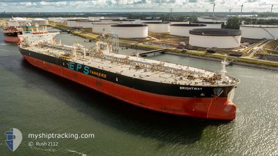
BRIGHTWAY
Crude Oil Tanker
Current Trip
| Time Travelled | 10 days |
|---|---|
| Remaining Time | --- |
| Distance Travelled | 2064.54 nm |
| Remaining Distance | --- |
| AVG Speed | 6.4 Knots |
| MAX Speed | 15.4 Knots |
| AVG Wind | 28.8 knots |
| MAX Wind | 52 knots |
| MIN Temp | 6.5°C / 43.7°F |
| MAX Temp | 18.7°C / 65.66°F |
| Draught | 9.2 m |
| Position Received | 4 d ago |
Current Position
| Longitude | -5.09109° |
|---|---|
| Latitude | 49.63637° |
| Status | Under way using engine |
| Speed | 12.4 Knots |
| Course | 216.3° |
| Area | English Channel |
| Station | T-AIS |
| Position Received | 4 d ago |
Info
Information
The current position of BRIGHTWAY is in English Channel with coordinates 49.63637° / -5.09109° as reported on 2025-01-29 21:10 by AIS to our vessel tracker app. The vessel's current speed is 12.4 Knots and is heading at the port of FALMOUTH. The estimated time of arrival as calculated by MyShipTracking vessel tracking app is 2025-01-29 12:00 LT
The vessel BRIGHTWAY (IMO: 9588146, MMSI: 566422000) is a Crude Oil Tanker that was built in 2012 ( 13 years old ). It's sailing under the flag of [SG] Singapore.
In this page you can find informations about the vessels current position, last detected port calls, and current voyage information. If the vessels is not in coverage by AIS you will find the latest position.
The current position of BRIGHTWAY is detected by our AIS receivers and we are not responsible for the reliability of the data. The last position was recorded while the vessel was in Coverage by the Ais receivers of our vessel tracking app.
The current draught of BRIGHTWAY as reported by AIS is 9.2 meters
Weather
| Temperature | 18.7°C / 65.66°F |
|---|---|
| Wind Speed | 12 knots |
| Direction | 22° NNE |
| Pressure | 1024.8 hPa |
| Humidity | 72.9 % |
| Cloud Coverage | 13 % |
Featured Company
Last Port Calls
| Port | Arrival | Departure | Time In Port |
|---|---|---|---|
| 2025-01-23 21:39 | 2025-01-24 15:08 | 17 h | |
| 2025-01-22 12:31 | 2025-01-23 21:24 | 1 d | |
| 2025-01-12 14:14 | 2025-01-14 02:21 | 1 d |
Last Trips
| Origin | Departure | Destination | Arrival | Distance | |
|---|---|---|---|---|---|
| 2025-01-23 22:24 | 2025-01-23 22:39 | 1.93 nm | |||
| 2025-01-14 03:21 | 2025-01-22 13:31 | 1752.11 nm | |||
| 2024-11-14 23:17 | 2025-01-12 15:14 | 5367.11 nm |
Events
| Time | Event | Details | Position / Dest | Info |
|---|---|---|---|---|
| 2025-01-29 21:15 | Status Changed | Default Under way using engine |
49.61999 / -5.10945
GBFAL
|
Speed: 12.4 kn Course: 216.3° |
| 2025-01-29 21:10 | OUT of Coverage |
49.63637 / -5.09109
English Channel
|
Speed: 12.4 kn Course: 216.3° |
|
| 2025-01-29 20:52 | Status Changed | Under way using engine Default |
49.68702 / -5.04228
GBFAL
|
Speed: 12.2 kn Course: 202° |
| 2025-01-29 20:51 | Status Changed | Default Under way using engine |
49.69034 / -5.04072
GBFAL
|
Speed: 11.6 kn Course: 192° |
| 2025-01-29 20:45 | Status Changed | Under way using engine Default |
49.71181 / -5.03134
GBFAL
|
Speed: 11.8 kn Course: 185° |
| 2025-01-29 20:39 | Status Changed | Default Under way using engine |
49.72977 / -5.02624
GBFAL
|
Speed: 11.8 kn Course: 186.6° |
| 2025-01-28 19:01 | Destination Changed | GBFAL NGFOR |
50.21910 / -2.67496
GBFAL
|
Speed: 2.5 kn Course: 267° |
| 2025-01-28 19:01 | ETA Changed | 2025/01/29 12:00 2025/02/08 05:00 |
50.21910 / -2.67496
GBFAL
|
Speed: 2.5 kn Course: 267° |
| 2025-01-28 14:06 | Status Changed | Under way using engine Default |
50.25025 / -2.18170
NGFOR
|
Speed: 4.7 kn Course: 263° |
| 2025-01-28 13:51 | Status Changed | Default Under way using engine |
50.24951 / -2.15219
NGFOR
|
Speed: 5.4 kn Course: 259.7° |