

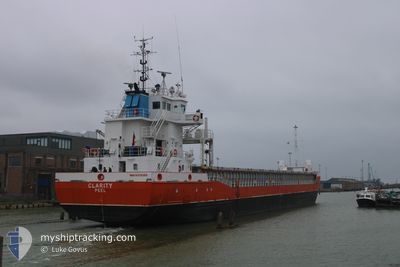
CLARITY
General Cargo
Current Trip
Current Position
| Longitude | 1.32112° |
|---|---|
| Latitude | 51.11667° |
| Status | Moored |
| Speed | |
| Course | 327° |
| Area | English Channel |
| Station | T-AIS |
| Position Received | 10 m ago |
Information
The current position of CLARITY is in English Channel with coordinates 51.11667° / 1.32112° as reported on 2025-03-11 06:30 by AIS to our vessel tracker app. The vessel's current speed is 0 Knots and is currently inside the port of DOVER.
The vessel CLARITY (IMO: 9370305, MMSI: 232043564) is a General Cargo that was built in 2011 ( 14 years old ). It's sailing under the flag of [GB] United Kingdom.
In this page you can find informations about the vessels current position, last detected port calls, and current voyage information. If the vessels is not in coverage by AIS you will find the latest position.
The current position of CLARITY is detected by our AIS receivers and we are not responsible for the reliability of the data. The last position was recorded while the vessel was in Coverage by the Ais receivers of our vessel tracking app.
The current draught of CLARITY as reported by AIS is 3.4 meters
Weather
| Temperature | 5.9°C / 42.62°F |
|---|---|
| Wind Speed | 22 knots |
| Direction | 20° NNE |
| Pressure | 1005.7 hPa |
| Humidity | 88.8 % |
| Cloud Coverage | 100 % |
Featured Company
Last Port Calls
| Port | Arrival | Departure | Time In Port |
|---|---|---|---|
| 2025-03-11 05:47 | |||
| 2025-03-09 04:28 | 2025-03-10 04:09 | 23 h | |
| 2025-03-01 15:35 | 2025-03-04 15:03 | 2 d | |
| 2025-02-27 01:00 | 2025-02-28 15:12 | 1 d | |
| 2025-02-21 06:47 | 2025-02-25 01:52 | 3 d | |
| 2025-02-19 13:59 | 2025-02-20 14:14 | 1 d | |
| 2025-02-12 08:26 | 2025-02-13 18:44 | 1 d | |
| 2025-02-10 15:42 | 2025-02-11 12:52 | 21 h | |
| 2025-02-05 04:37 | 2025-02-06 17:59 | 1 d | |
| 2025-02-02 19:14 | 2025-02-04 15:23 | 1 d |
Last Trips
| Origin | Departure | Destination | Arrival | Distance | |
|---|---|---|---|---|---|
| 2025-03-10 04:09 | 2025-03-11 05:47 | 91.32 nm | |||
| 2025-03-04 15:03 | 2025-03-09 04:28 | 460.42 nm | |||
| 2025-02-28 15:12 | 2025-03-01 15:35 | 91.60 nm | |||
| 2025-02-25 02:52 | 2025-02-27 01:00 | 436.08 nm | |||
| 2025-02-20 14:14 | 2025-02-21 07:47 | 183.49 nm | |||
| 2025-02-13 18:44 | 2025-02-19 13:59 | 543.19 nm | |||
| 2025-02-11 12:52 | 2025-02-12 08:26 | 213.33 nm | |||
| 2025-02-06 18:59 | 2025-02-10 15:42 | 733.53 nm | |||
| 2025-02-04 15:23 | 2025-02-05 05:37 | 132.30 nm | |||
| 2025-01-30 17:37 | 2025-02-02 19:14 | 697.34 nm |
Events
| Time | Event | Details | Position / Dest | Info |
|---|---|---|---|---|
| 2025-03-11 06:39 | Status Changed | Moored Default |
51.11667 / 1.32113
[GB] DOVER
|
Speed: Course: 328° |
| 2025-03-11 06:36 | Status Changed | Default Moored |
51.11666 / 1.32113
[GB] DOVER
|
Speed: Course: 327° |
| 2025-03-11 06:10 | Status Changed | Moored Under way using engine |
51.11666 / 1.32112
[GB] DOVER
|
Speed: Course: 328° |
| 2025-03-11 06:08 | STOP Moving |
51.11666 / 1.32116
[GB] DOVER
|
Speed: 0.3 kn Course: 333° |
|
| 2025-03-11 05:47 | PORT ARRIVAL |
|
51.12085 / 1.34331
[GB] DOVER
|
Speed: 7.6 kn Course: 256.1° |
| 2025-03-11 05:32 | Change Sea Area | United Kingdom part of the English Channel United Kingdom part of the North Sea |
51.12146 / 1.39257
English Channel
|
Speed: 5.7 kn Course: 254.5° |
| 2025-03-11 04:21 | START Moving | 5.58 nm, North East of DOVER |
51.18894 / 1.42850
GBDVR
|
Speed: 3.1 kn Course: 101° |
| 2025-03-11 04:19 | Status Changed | Under way using engine At anchor |
51.18991 / 1.42769
GBDVR
|
Speed: 0.9 kn Course: 40° |
| 2025-03-10 13:36 | Status Changed | At anchor Default |
51.18999 / 1.42788
GBDVR
|
Speed: Course: 8° |
| 2025-03-10 13:33 | Status Changed | Default At anchor |
51.18999 / 1.42768
GBDVR
|
Speed: 0.1 kn Course: 356° |